Photographic Print > Arts > Contemporary art > Digital artwork > Street art
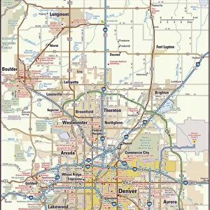
Photographic Print : MA Middlesex Wilmington Vector Road Map

![]()
Photo Prints from Fine Art Storehouse
MA Middlesex Wilmington Vector Road Map
MA Middlesex Wilmington Vector Road Map. All source data is in the public domain. U.S. Census Bureau Census Tiger. Used Layers: areawater, linearwater, roads, rails, cousub, pointlm, uac10
Unleash your creativity and transform your space into a visual masterpiece!
Frank Ramspott
Media ID 20691033
© Frank Ramspott, all rights reserved
City Map Computer Graphic County Digital Composite District Geographical Border Massachusetts Middlesex Road Map Text Vector Digitally Generated Image Fox Hill Pinehurst Silver Lake Tewksbury The Pines West Village Wilmington
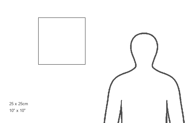
10"x10" Photo Print
Discover the unique blend of art and functionality with our MA Middlesex Wilmington Vector Road Map print from the Media Storehouse Fine Art collection. This stunning piece, created by Frank Ramspott, transforms traditional cartography into an elegant work of art. With all source data in the public domain, every line and point on this map is meticulously rendered in vector format, ensuring crisp lines and clear details. The U.S. Census Bureau Tiger data layers used include areawater, linearwater, roads, rails, cousub, pointlm, and uac10. Perfect for decorating your home or office, this map print is not just a beautiful addition to any space, but also a conversation starter. Experience the harmony of art and information with the MA Middlesex Wilmington Vector Road Map print.
Photo prints are produced on Kodak professional photo paper resulting in timeless and breath-taking prints which are also ideal for framing. The colors produced are rich and vivid, with accurate blacks and pristine whites, resulting in prints that are truly timeless and magnificent. Whether you're looking to display your prints in your home, office, or gallery, our range of photographic prints are sure to impress. Dimensions refers to the size of the paper in inches.
Our Photo Prints are in a large range of sizes and are printed on Archival Quality Paper for excellent colour reproduction and longevity. They are ideal for framing (our Framed Prints use these) at a reasonable cost. Alternatives include cheaper Poster Prints and higher quality Fine Art Paper, the choice of which is largely dependant on your budget.
Estimated Product Size is 25.4cm x 25.4cm (10" x 10")
These are individually made so all sizes are approximate
Artwork printed orientated as per the preview above, with landscape (horizontal) or portrait (vertical) orientation to match the source image.
FEATURES IN THESE COLLECTIONS
> Fine Art Storehouse
> Map
> Reference Maps
> Animals
> Mammals
> Cats (Wild)
> Tiger
> Arts
> Contemporary art
> Digital artwork
> Street art
> Arts
> Street art graffiti
> Digital art
> Digital paintings
> Europe
> United Kingdom
> England
> Middlesex
> Related Images
> Maps and Charts
> Related Images
> Popular Themes
> Lake District
EDITORS COMMENTS
This print showcases the intricate details of the MA Middlesex Wilmington Vector Road Map. Created by talented cartographer Frank Ramspott, this digitally generated image is a testament to his exceptional design skills and expertise in the field of cartography. The map encompasses various layers including areawater, linearwater, roads, rails, cousub, pointlm, and uac10 - all sourced from the public domain data provided by the U. S. Census Bureau Census Tiger. The vibrant colors and precise vector lines bring this physical geography to life on paper. With no people present in the image, it allows viewers to solely focus on the beauty and functionality of this city map. From bustling urban areas to serene bodies of water like rivers and lakes, every element has been carefully crafted to accurately represent Middlesex County's diverse landscape. Highlighted within this detailed map are notable locations such as West Village, Silver Lake, Tewksbury, East Billerica, Fox Hill, The Pines, and Pinehurst - each contributing their unique charm to Middlesex Wilmington's tapestry. Whether you're a resident or simply fascinated by cartographic artistry, this stunning print is bound to captivate your imagination with its digital composite that seamlessly blends geographical borders, text, and street networks into one cohesive masterpiece.
MADE IN THE USA
Safe Shipping with 30 Day Money Back Guarantee
FREE PERSONALISATION*
We are proud to offer a range of customisation features including Personalised Captions, Color Filters and Picture Zoom Tools
SECURE PAYMENTS
We happily accept a wide range of payment options so you can pay for the things you need in the way that is most convenient for you
* Options may vary by product and licensing agreement. Zoomed Pictures can be adjusted in the Cart.