Metal Print > Arts > Contemporary art > Digital artwork > Street art
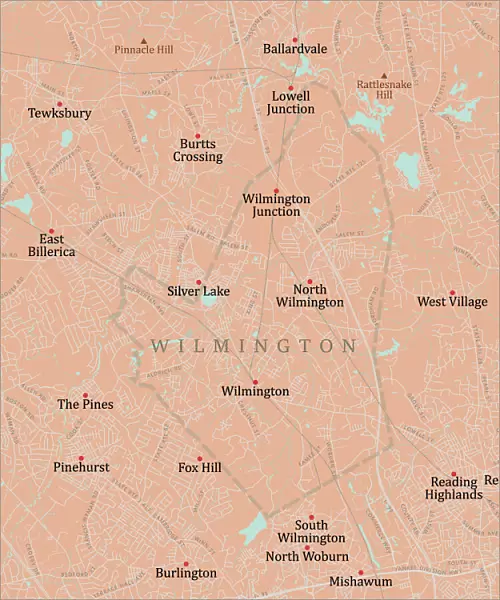
Metal Print : MA Middlesex Wilmington Vector Road Map

![]()
Metal Prints from Fine Art Storehouse
MA Middlesex Wilmington Vector Road Map
MA Middlesex Wilmington Vector Road Map. All source data is in the public domain. U.S. Census Bureau Census Tiger. Used Layers: areawater, linearwater, roads, rails, cousub, pointlm, uac10
Unleash your creativity and transform your space into a visual masterpiece!
Frank Ramspott
Media ID 20691033
© Frank Ramspott, all rights reserved
City Map Computer Graphic County Digital Composite District Geographical Border Massachusetts Middlesex Road Map Text Vector Digitally Generated Image Fox Hill Pinehurst Silver Lake Tewksbury The Pines West Village Wilmington
20"x24" (61x51cm) Metal Print
Discover the unique charm of the MA Middlesex Wilmington Vector Road Map by Frank Ramspott, now available as a stunning Metal Print from Media Storehouse. This intricately detailed map, featuring roads, rails, waterways, and more, is meticulously crafted from public domain data. The high-quality Metal Print process ensures vibrant colors and exceptional durability, making it an ideal addition to any space. Bring the history and character of Wilmington, Massachusetts, into your home or office with this eye-catching and conversation-starting piece. All source data is from the U.S. Census Bureau Census Tiger, and the map is available as a vector file, ensuring crisp lines and clear details at any size. Order your MA Middlesex Wilmington Vector Road Map Metal Print today and experience the beauty of Frank Ramspott's artistry in a whole new way.
Made with durable metal and luxurious printing techniques, our metal photo prints go beyond traditional canvases, adding a cool, modern touch to your space. Wall mount on back. Eco-friendly 100% post-consumer recycled ChromaLuxe aluminum surface. The thickness of the print is 0.045". Featuring a Scratch-resistant surface and Rounded corners. Backing hangers are attached to the back of the print and float the print 1/2-inch off the wall when hung, the choice of hanger may vary depending on size and International orders will come with Float Mount hangers only. Finished with a brilliant white high gloss surface for unsurpassed detail and vibrance. Printed using Dye-Sublimation and for best care we recommend a non-ammonia glass cleaner, water, or isopropyl (rubbing) alcohol to prevent harming the print surface. We recommend using a clean, lint-free cloth to wipe off the print. The ultra-hard surface is scratch-resistant, waterproof and weatherproof. Avoid direct sunlight exposure.
Made with durable metal and luxurious printing techniques, metal prints bring images to life and add a modern touch to any space
Estimated Image Size (if not cropped) is 50.8cm x 60.9cm (20" x 24")
Estimated Product Size is 51.4cm x 61.5cm (20.2" x 24.2")
These are individually made so all sizes are approximate
Artwork printed orientated as per the preview above, with portrait (vertical) orientation to match the source image.
FEATURES IN THESE COLLECTIONS
> Fine Art Storehouse
> Map
> Reference Maps
> Animals
> Mammals
> Cats (Wild)
> Tiger
> Arts
> Contemporary art
> Digital artwork
> Street art
> Arts
> Street art graffiti
> Digital art
> Digital paintings
> Europe
> United Kingdom
> England
> Middlesex
> Related Images
> Maps and Charts
> Related Images
> Popular Themes
> Lake District
EDITORS COMMENTS
This print showcases the intricate details of the MA Middlesex Wilmington Vector Road Map. Created by talented cartographer Frank Ramspott, this digitally generated image is a testament to his exceptional design skills and expertise in the field of cartography. The map encompasses various layers including areawater, linearwater, roads, rails, cousub, pointlm, and uac10 - all sourced from the public domain data provided by the U. S. Census Bureau Census Tiger. The vibrant colors and precise vector lines bring this physical geography to life on paper. With no people present in the image, it allows viewers to solely focus on the beauty and functionality of this city map. From bustling urban areas to serene bodies of water like rivers and lakes, every element has been carefully crafted to accurately represent Middlesex County's diverse landscape. Highlighted within this detailed map are notable locations such as West Village, Silver Lake, Tewksbury, East Billerica, Fox Hill, The Pines, and Pinehurst - each contributing their unique charm to Middlesex Wilmington's tapestry. Whether you're a resident or simply fascinated by cartographic artistry, this stunning print is bound to captivate your imagination with its digital composite that seamlessly blends geographical borders, text, and street networks into one cohesive masterpiece.
MADE IN THE USA
Safe Shipping with 30 Day Money Back Guarantee
FREE PERSONALISATION*
We are proud to offer a range of customisation features including Personalised Captions, Color Filters and Picture Zoom Tools
SECURE PAYMENTS
We happily accept a wide range of payment options so you can pay for the things you need in the way that is most convenient for you
* Options may vary by product and licensing agreement. Zoomed Pictures can be adjusted in the Cart.