Metal Print > North America > United States of America > Massachusetts > Worcester
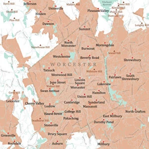
Metal Print : MA Worcester Northborough Vector Road Map


![]()
Metal Prints from Fine Art Storehouse
MA Worcester Northborough Vector Road Map
MA Worcester Northborough Vector Road Map. All source data is in the public domain. U.S. Census Bureau Census Tiger. Used Layers: areawater, linearwater, roads, rails, cousub, pointlm, uac10
Unleash your creativity and transform your space into a visual masterpiece!
Frank Ramspott
Media ID 20691897
© Frank Ramspott, all rights reserved
City Map Computer Graphic County Digital Composite District Geographical Border Massachusetts Road Map Text Vector Worcester Digitally Generated Image West Village Woodside
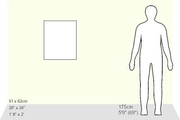
20"x24" (61x51cm) Metal Print
Discover the unique charm of the MA Worcester Northborough Vector Road Map by Frank Ramspott, now available as a stunning Metal Print from Media Storehouse. This intricately detailed map, featuring public domain data from the U.S. Census Bureau Census Tiger, is expertly rendered in vector format. The vibrant colors and sharp lines of this map pop against the sleek, modern surface of the metal print, making it a captivating addition to any home or office. With its eye-catching design and high-quality craftsmanship, this Metal Print is sure to make a statement and ignite conversation. Order yours today and bring the beauty of cartography into your space.
Made with durable metal and luxurious printing techniques, our metal photo prints go beyond traditional canvases, adding a cool, modern touch to your space. Wall mount on back. Eco-friendly 100% post-consumer recycled ChromaLuxe aluminum surface. The thickness of the print is 0.045". Featuring a Scratch-resistant surface and Rounded corners. Backing hangers are attached to the back of the print and float the print 1/2-inch off the wall when hung, the choice of hanger may vary depending on size and International orders will come with Float Mount hangers only. Finished with a brilliant white high gloss surface for unsurpassed detail and vibrance. Printed using Dye-Sublimation and for best care we recommend a non-ammonia glass cleaner, water, or isopropyl (rubbing) alcohol to prevent harming the print surface. We recommend using a clean, lint-free cloth to wipe off the print. The ultra-hard surface is scratch-resistant, waterproof and weatherproof. Avoid direct sunlight exposure.
Made with durable metal and luxurious printing techniques, metal prints bring images to life and add a modern touch to any space
Estimated Image Size (if not cropped) is 50.8cm x 60.9cm (20" x 24")
Estimated Product Size is 51.4cm x 61.5cm (20.2" x 24.2")
These are individually made so all sizes are approximate
Artwork printed orientated as per the preview above, with portrait (vertical) orientation to match the source image.
FEATURES IN THESE COLLECTIONS
> Fine Art Storehouse
> Map
> Reference Maps
> Animals
> Mammals
> Cats (Wild)
> Tiger
> Arts
> Contemporary art
> Digital artwork
> Street art
> Arts
> Street art graffiti
> Digital art
> Digital paintings
> Maps and Charts
> Related Images
> North America
> United States of America
> Massachusetts
> Worcester
> Popular Themes
> Lake District
EDITORS COMMENTS
This print showcases the MA Worcester Northborough Vector Road Map, a stunning piece of cartography art. Designed by Frank Ramspott, this digitally generated image beautifully captures the intricate details of Massachusetts' geography. The map incorporates various layers such as areawater, linearwater, roads, rails, cousub, pointlm, and uac10 sourced from the public domain U. S. Census Bureau Census Tiger data. In this colorful and vibrant city map, you can explore the charming cities and districts within Worcester County. From bustling urban areas like Worcester itself to serene lakeside communities like Woodside and Chapinville, every corner is meticulously depicted with precision. The inclusion of rivers and lakes adds an element of natural beauty to this digital composite artwork. The text on the map helps navigate through streets and highlights significant landmarks throughout the region. With no people in sight but bursting with life through its vivid colors and detailed design elements, this vector road map print is a must-have for any geography enthusiast or lover of fine art. It serves as both a functional tool for navigation purposes as well as an aesthetically pleasing piece that will enhance any space it graces
MADE IN THE USA
Safe Shipping with 30 Day Money Back Guarantee
FREE PERSONALISATION*
We are proud to offer a range of customisation features including Personalised Captions, Color Filters and Picture Zoom Tools
SECURE PAYMENTS
We happily accept a wide range of payment options so you can pay for the things you need in the way that is most convenient for you
* Options may vary by product and licensing agreement. Zoomed Pictures can be adjusted in the Cart.