Metal Print > Arts > Contemporary art > Digital artwork > Street art
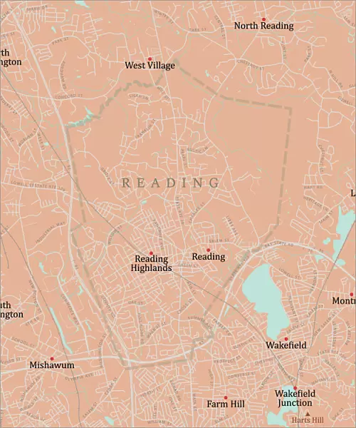
Metal Print : MA Middlesex Reading Vector Road Map

![]()
Metal Prints from Fine Art Storehouse
MA Middlesex Reading Vector Road Map
MA Middlesex Reading Vector Road Map. All source data is in the public domain. U.S. Census Bureau Census Tiger. Used Layers: areawater, linearwater, roads, rails, cousub, pointlm, uac10
Unleash your creativity and transform your space into a visual masterpiece!
Frank Ramspott
Media ID 20691121
© Frank Ramspott, all rights reserved
City Map Computer Graphic County Digital Composite District Geographical Border Massachusetts Middlesex Reading Road Map Text Vector Digitally Generated Image Wakefield West Village
20"x24" (61x51cm) Metal Print
Discover the captivating fusion of art and topography with our MA Middlesex Reading Vector Road Map Metal Print from Media Storehouse. This stunning piece, created by Frank Ramspott from Fine Art Storehouse, transforms the census data of the Middlesex County, Massachusetts area into a visually striking representation of roads, rails, and waterways. Each line and point meticulously rendered in vector format, ensuring crisp, clean lines and vibrant colors that pop on the metal surface. Bring a unique, modern touch to your space while celebrating the intricacies of urban planning and cartography. All source data is in the public domain, sourced from the U.S. Census Bureau Census Tiger.
Made with durable metal and luxurious printing techniques, our metal photo prints go beyond traditional canvases, adding a cool, modern touch to your space. Wall mount on back. Eco-friendly 100% post-consumer recycled ChromaLuxe aluminum surface. The thickness of the print is 0.045". Featuring a Scratch-resistant surface and Rounded corners. Backing hangers are attached to the back of the print and float the print 1/2-inch off the wall when hung, the choice of hanger may vary depending on size and International orders will come with Float Mount hangers only. Finished with a brilliant white high gloss surface for unsurpassed detail and vibrance. Printed using Dye-Sublimation and for best care we recommend a non-ammonia glass cleaner, water, or isopropyl (rubbing) alcohol to prevent harming the print surface. We recommend using a clean, lint-free cloth to wipe off the print. The ultra-hard surface is scratch-resistant, waterproof and weatherproof. Avoid direct sunlight exposure.
Made with durable metal and luxurious printing techniques, metal prints bring images to life and add a modern touch to any space
Estimated Image Size (if not cropped) is 50.8cm x 60.9cm (20" x 24")
Estimated Product Size is 51.4cm x 61.5cm (20.2" x 24.2")
These are individually made so all sizes are approximate
Artwork printed orientated as per the preview above, with portrait (vertical) orientation to match the source image.
FEATURES IN THESE COLLECTIONS
> Fine Art Storehouse
> Map
> Reference Maps
> Animals
> Mammals
> Cats (Wild)
> Tiger
> Arts
> Contemporary art
> Digital artwork
> Street art
> Arts
> Street art graffiti
> Digital art
> Digital paintings
> Europe
> United Kingdom
> England
> Middlesex
> Related Images
> Europe
> United Kingdom
> Scotland
> Highlands
> Related Images
> Maps and Charts
> Related Images
> Popular Themes
> Lake District
EDITORS COMMENTS
This vibrant and detailed print captures the essence of Middlesex County, Massachusetts with its MA Middlesex Reading Vector Road Map. Created by talented cartographer Frank Ramspott, this digitally generated image showcases the intricate road network, water bodies, and geographical borders of the region. The map is a testament to the power of technology and data accessibility as it utilizes public domain information from the U. S. Census Bureau Census Tiger. Various layers such as areawater, linearwater, roads, rails, cousub, pointlm, and uac10 have been skillfully combined to create this visually appealing composition. With no people present in the picture itself but an abundance of colorful elements like rivers and lakes depicted through vector graphics, this artwork focuses solely on showcasing the physical geography of Middlesex County. The inclusion of city names like Reading Highlands, Mishawum, Wakefield, and West Village adds a sense of familiarity for locals or those familiar with these areas. Whether you're a resident or simply fascinated by maps and design aesthetics, this print will surely make a striking addition to any space. Its computer-generated imagery highlights both functionality and beauty in equal measure while paying homage to the rich history and diverse landscapes that define Middlesex County.
MADE IN THE USA
Safe Shipping with 30 Day Money Back Guarantee
FREE PERSONALISATION*
We are proud to offer a range of customisation features including Personalised Captions, Color Filters and Picture Zoom Tools
SECURE PAYMENTS
We happily accept a wide range of payment options so you can pay for the things you need in the way that is most convenient for you
* Options may vary by product and licensing agreement. Zoomed Pictures can be adjusted in the Cart.