Photographic Print > Aerial Photography > Africa
Photographic Print : Eurasia, topographic map

![]()
Photo Prints from Science Photo Library
Eurasia, topographic map
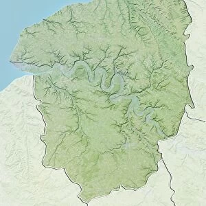
Eurasia, topographic map. This map is centred on Russia, with Europe at centre left and East Asia at right. The North Pole (upper left), with Greenland shown in white, and Africa (lower left) are also seen. The seabed depth varies from shallow (light blue) on the continental shelves, to deep ocean basins (dark blue). Highlands and lowlands of the continents are shown as ridges and flat areas. Topographic and bathymetric data is usually gathered by using aerial and satellite imagery combined with radar and sonar mapping
Science Photo Library features Science and Medical images including photos and illustrations
Media ID 1705043
© PLANETARY VISIONS LTD/SCIENCE PHOTO LIBRARY
Africa Altimetric Altimetry Arctic Arctic Ocean Atlantic Ocean Basin Bathymetric Bathymetry Circle Circular Combined Data Continent Continental Shelf Continents Data Depth Depths East Asia Eurasia Floor Globe Greenland Highlands Indian Ocean Land Lowlands Mapped Mountains North Pole Oceanic Oceanographic Oceanography Physical Geography Plains Polar Radar Region Ridge Round Russia Satellite Satellite Image Sea Bed Sea Floor Shelves Sonar Mapping Sonic Sphere Spherical Topographic Topography World
10"x10" Photo Print
Discover the breathtaking beauty of our world with Media Storehouse's range of Photographic Prints. This captivating image, "Eurasia, Topographic Map" from Science Photo Library, offers a unique perspective on our planet. With Russia at the heart, Europe to the left, and East Asia to the right, this topographic map transports you to a world of intricate detail and geographical wonders. Experience the stunning contrasts of our diverse continents, from the icy expanse of the North Pole to the vibrant colors of Europe and Asia. Bring this mesmerizing piece of art into your home or office and let it inspire your imagination every day.
Photo prints are produced on Kodak professional photo paper resulting in timeless and breath-taking prints which are also ideal for framing. The colors produced are rich and vivid, with accurate blacks and pristine whites, resulting in prints that are truly timeless and magnificent. Whether you're looking to display your prints in your home, office, or gallery, our range of photographic prints are sure to impress. Dimensions refers to the size of the paper in inches.
Our Photo Prints are in a large range of sizes and are printed on Archival Quality Paper for excellent colour reproduction and longevity. They are ideal for framing (our Framed Prints use these) at a reasonable cost. Alternatives include cheaper Poster Prints and higher quality Fine Art Paper, the choice of which is largely dependant on your budget.
Estimated Product Size is 25.4cm x 25.4cm (10" x 10")
These are individually made so all sizes are approximate
Artwork printed orientated as per the preview above, with landscape (horizontal) or portrait (vertical) orientation to match the source image.
FEATURES IN THESE COLLECTIONS
> Aerial Photography
> Related Images
> Animals
> Mammals
> Cats (Domestic)
> Russian Blue
> Animals
> Mammals
> Cats (Domestic)
> Russian White
> Animals
> Mammals
> Muridae
> Plains Mouse
> Arts
> Artists
> O
> Oceanic Oceanic
> Europe
> France
> Canton
> Landes
> Science Photo Library
> Aerial and Satellite
EDITORS COMMENTS
This print showcases a detailed topographic map of Eurasia, with Russia at its center. The vastness of this continent is beautifully depicted, as Europe occupies the left side while East Asia stretches out on the right. This comprehensive map also includes other significant regions such as Africa and Greenland. The varying depths of the seabed are represented by shades of blue, ranging from light hues near the continental shelves to darker tones in deep ocean basins. To gather this valuable data, a combination of aerial and satellite imagery, along with radar and sonar mapping techniques were employed. The contours on the map reveal both highlands and lowlands across different continents, creating an intricate network of ridges and flat areas. As we explore this visual representation, it becomes evident that our planet's geography is truly diverse and awe-inspiring. With its circular shape resembling a globe, this print serves as a reminder that Earth is an interconnected sphere where landmasses seamlessly blend into marine environments. It highlights not only the physical features but also emphasizes how crucial it is to understand our world's topography for scientific research purposes. This remarkable image has been captured by Science Photo Library—an expert in providing exceptional visuals related to various scientific fields—making it an invaluable addition for anyone interested in geography or oceanography.
MADE IN THE USA
Safe Shipping with 30 Day Money Back Guarantee
FREE PERSONALISATION*
We are proud to offer a range of customisation features including Personalised Captions, Color Filters and Picture Zoom Tools
SECURE PAYMENTS
We happily accept a wide range of payment options so you can pay for the things you need in the way that is most convenient for you
* Options may vary by product and licensing agreement. Zoomed Pictures can be adjusted in the Cart.