Fine Art Print > Europe > United Kingdom > Wales > Related Images
Fine Art Print : Wales, UK, satellite image


![]()
Fine Art Prints from Science Photo Library
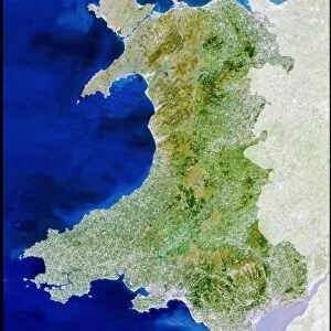
Wales, UK, satellite image
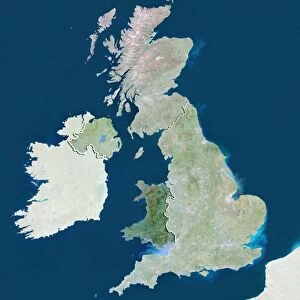
Wales, UK. North is at top. Natural colour satellite image showing Wales in the United Kingdom, with the surrounding territories shaded out. The UK consists of the island of Great Britain and Northern Ireland - the north-eastern part of the island of Ireland (not shown). Together these islands constitute the British Isles. Great Britain itself consists of Scotland (not seen), England (right), and Wales (green). The Irish Sea (blue, upper left and centre left), and Celtic Sea (lower left) are also shown. Image compiled from data acquired by the LANDSAT 5 and 7 satellites, in 2000. Images highlighting all other regions of this country are available. For further information please contact SPL
Science Photo Library features Science and Medical images including photos and illustrations
Media ID 9214499
© PLANETOBSERVER/SCIENCE PHOTO LIBRARY
2000 Atlantic Ocean Birds Eye View Border Borders Boundaries Boundary British Isles Cartography Coast Coastal Coastline Countries Country Earth Observation English Channel Environmental From Above From Space Frontier Frontiers Great Britain Irish Sea Land Landsat 5 Landsat 7 Masked Nation Natural Colour Satellite Satellite Image Shore Shoreline State Topographic Topography Wales Celtic Sea
20"x16" (+3" Border) Fine Art Print
Discover the breathtaking beauty of Wales with our Fine Art Prints from Media Storehouse. This exquisite piece showcases a unique perspective of the Welsh landscape, captured through the lens of Science Photo Library's satellite imagery. Witness the undulating hills, the winding rivers, and the vast expanse of the Irish Sea, all in stunning, natural color detail. Bring the enchanting scenery of Wales into your home or office and elevate your space with this captivating work of art.
20x16 image printed on 26x22 Fine Art Rag Paper with 3" (76mm) white border. Our Fine Art Prints are printed on 300gsm 100% acid free, PH neutral paper with archival properties. This printing method is used by museums and art collections to exhibit photographs and art reproductions.
Our fine art prints are high-quality prints made using a paper called Photo Rag. This 100% cotton rag fibre paper is known for its exceptional image sharpness, rich colors, and high level of detail, making it a popular choice for professional photographers and artists. Photo rag paper is our clear recommendation for a fine art paper print. If you can afford to spend more on a higher quality paper, then Photo Rag is our clear recommendation for a fine art paper print.
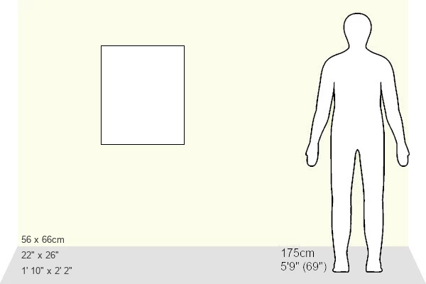
Estimated Image Size (if not cropped) is 36cm x 50.8cm (14.2" x 20")
Estimated Product Size is 55.9cm x 66cm (22" x 26")
These are individually made so all sizes are approximate
Artwork printed orientated as per the preview above, with portrait (vertical) orientation to match the source image.
FEATURES IN THESE COLLECTIONS
> Europe
> United Kingdom
> Northern Ireland
> Related Images
> Europe
> United Kingdom
> Wales
> Related Images
EDITORS COMMENTS
This stunning satellite image captures the breathtaking beauty of Wales, UK, from a unique perspective. The photograph showcases the natural color and topography of this enchanting country, with its lush green landscapes dominating the scene. Situated in the United Kingdom, Wales is one of three constituent countries that make up Great Britain. The image highlights Wales' coastal charm as it borders both the Irish Sea and Celtic Sea. The English Channel and Atlantic Ocean can also be seen in the distance, emphasizing its strategic location within Europe. This snapshot was compiled using data acquired by LANDSAT 5 and 7 satellites in 2000, offering an extraordinary birds-eye view of this picturesque nation. Wales boasts a rich history and diverse geography that attracts visitors from all over the world. From rugged mountains to serene coastlines, this region offers a wide range of natural wonders to explore. Its distinctive culture and language add to its allure as a must-visit destination for nature enthusiasts. Whether you are fascinated by cartography or simply appreciate Earth's remarkable beauty from space, this print provides an awe-inspiring glimpse into Wales' geographical features. For more information about other regions captured through satellite imagery or commercial use inquiries regarding Science Photo Library's collection, please contact them directly.
MADE IN THE USA
Safe Shipping with 30 Day Money Back Guarantee
FREE PERSONALISATION*
We are proud to offer a range of customisation features including Personalised Captions, Color Filters and Picture Zoom Tools
SECURE PAYMENTS
We happily accept a wide range of payment options so you can pay for the things you need in the way that is most convenient for you
* Options may vary by product and licensing agreement. Zoomed Pictures can be adjusted in the Cart.