Premium Framed Print > Animals > Fishes > G > Grouper
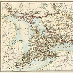
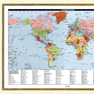
Premium Framed Print : 1806 Cary Map Of Florida Georgia North Carolina


![]()
Framed Photos from Universal Images Group (UIG)
1806 Cary Map Of Florida Georgia North Carolina
1806, Cary Map of Florida, Georgia, North Carolina, South Carolina and Tennessee, John Cary, 1754 - 1835, English cartographer
Universal Images Group (UIG) manages distribution for many leading specialist agencies worldwide
Media ID 38548377
© Artokoloro Quint Lox Limited
1754 – 1835 1806 English Cartographer Georgia John Cary North Carolina Antique Map Latitude Longitude Mappa Mundi Old Antique Plan Old Antique View Ols Antique Map Rare Old Maps Topo
14"x16" Premium Frame
Contemporary style Premium Wooden Frame with 8"x10" Print. Complete with 2" White Mat and 1.25" thick MDF frame. Printed on 260 gsm premium paper. Glazed with shatter proof UV coated acrylic glass. Backing is paper covered backing with rubber bumpers. Supplied ready to hang with a pre-installed sawtooth/wire hanger. Care Instructions: Spot clean with a damp cloth. Securely packaged in a clear plastic bag and envelope in a reinforced cardboard shipper
FSC Real Wood Frame and Double Mounted with White Conservation Mountboard - Professionally Made and Ready to Hang
Estimated Image Size (if not cropped) is 25.4cm x 20.3cm (10" x 8")
Estimated Product Size is 40.6cm x 35.6cm (16" x 14")
These are individually made so all sizes are approximate
Artwork printed orientated as per the preview above, with landscape (horizontal) orientation to match the source image.
FEATURES IN THESE COLLECTIONS
> Animals
> Fishes
> G
> Grouper
> Asia
> Georgia
> Related Images
> Europe
> France
> Canton
> Landes
> Historic
> Space exploration
> Maps and Charts
> Early Maps
> Maps and Charts
> Related Images
> Maps and Charts
> World
> Universal Images Group (UIG)
> History
> Historical Maps
EDITORS COMMENTS
Step back in time to the early 19th century with this stunning print of John Cary's 1806 map of Florida, Georgia, North Carolina, South Carolina, and Tennessee. This beautifully rendered illustration is a testament to the cartographer's skill and attention to detail.
The map showcases the southeastern United States during a pivotal moment in its history, just before the War of 1812. The region is depicted with remarkable accuracy, featuring intricate details such as rivers, mountains, and towns. The cartographer's use of color adds depth and visual interest to the design.
This vintage map is not only a fascinating piece of historical geography but also an artful representation of the region's natural beauty. It would make a unique addition to any room or office space that celebrates exploration, travel, or history.
Printed on high-quality paper for durability and longevity, this reproduction captures every nuance of Cary's original work. It stands as a tribute to his legacy as one of England's most renowned cartographers during the late 18th and early 19th centuries.
MADE IN THE USA
Safe Shipping with 30 Day Money Back Guarantee
FREE PERSONALISATION*
We are proud to offer a range of customisation features including Personalised Captions, Color Filters and Picture Zoom Tools
SECURE PAYMENTS
We happily accept a wide range of payment options so you can pay for the things you need in the way that is most convenient for you
* Options may vary by product and licensing agreement. Zoomed Pictures can be adjusted in the Cart.