Premium Framed Print > North America > United States of America > New York > New York > Maps
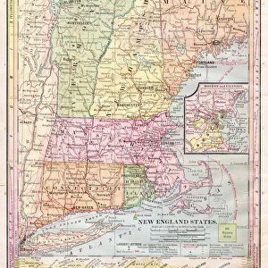
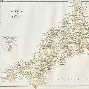
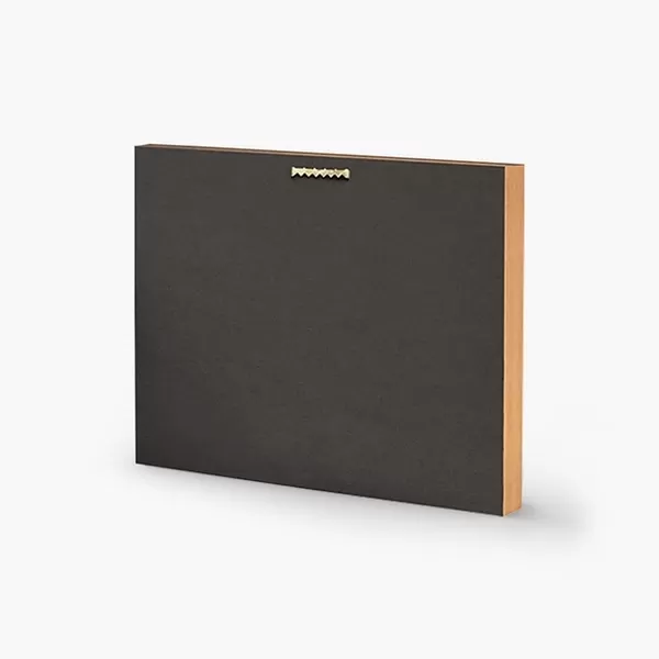
Premium Framed Print : Map of New England states 1895


![]()
Framed Photos from Fine Art Storehouse
Map of New England states 1895
The Rand-McNally Grammar School Geography 1895 - Chicago & New York
Unleash your creativity and transform your space into a visual masterpiece!
THEPALMER
Media ID 14824635
© This content is subject to copyright
Connecticut Maine Massachusetts New England New Hampshire Rhode Island Vermont
14"x16" Premium Frame
Contemporary style Premium Wooden Frame with 8"x10" Print. Complete with 2" White Mat and 1.25" thick MDF frame. Printed on 260 gsm premium paper. Glazed with shatter proof UV coated acrylic glass. Backing is paper covered backing with rubber bumpers. Supplied ready to hang with a pre-installed sawtooth/wire hanger. Care Instructions: Spot clean with a damp cloth. Securely packaged in a clear plastic bag and envelope in a reinforced cardboard shipper
FSC Real Wood Frame and Double Mounted with White Conservation Mountboard - Professionally Made and Ready to Hang
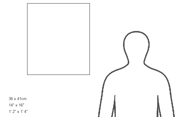
Estimated Image Size (if not cropped) is 20.3cm x 25.4cm (8" x 10")
Estimated Product Size is 35.6cm x 40.6cm (14" x 16")
These are individually made so all sizes are approximate
Artwork printed orientated as per the preview above, with portrait (vertical) orientation to match the source image.
FEATURES IN THESE COLLECTIONS
> Fine Art Storehouse
> Map
> Historical Maps
> Europe
> France
> Canton
> Maine
> Europe
> United Kingdom
> England
> Hampshire
> Related Images
> Europe
> United Kingdom
> England
> Maps
> Europe
> United Kingdom
> England
> York
> Maps and Charts
> Related Images
> North America
> United States of America
> New York
> New York
> Maps
> North America
> United States of America
> New York
> Related Images
EDITORS COMMENTS
In this print titled "Map of New England states 1895" we are transported back in time to a bygone era. The map, sourced from "The Rand-McNally Grammar School Geography 1895 - Chicago & New York" offers a fascinating glimpse into the geographical landscape of Connecticut, New Hampshire, Rhode Island, Vermont, Maine, and Massachusetts. As we delve into the intricacies of this vintage piece, our eyes are immediately drawn to the exquisite details meticulously captured by THEPALMER. Every contour and boundary is flawlessly depicted on this historical artifact. The faded hues and delicate lines evoke a sense of nostalgia that transports us to an era when cartography was both an art form and a scientific endeavor. This particular map serves as more than just a visual representation; it acts as a portal through which we can explore the rich history and cultural heritage of these northeastern states. It invites us to embark on an imaginary journey through quaint towns, picturesque landscapes, and bustling cities that have witnessed centuries of growth and transformation. Whether you're an avid collector or simply appreciate the beauty found in antique maps like this one from Fine Art Storehouse's collection curated by THEPALMER – its charm is undeniable. This remarkable artwork not only celebrates our shared past but also reminds us how far we've come since those early days when explorers first set foot on American soil.
MADE IN THE USA
Safe Shipping with 30 Day Money Back Guarantee
FREE PERSONALISATION*
We are proud to offer a range of customisation features including Personalised Captions, Color Filters and Picture Zoom Tools
SECURE PAYMENTS
We happily accept a wide range of payment options so you can pay for the things you need in the way that is most convenient for you
* Options may vary by product and licensing agreement. Zoomed Pictures can be adjusted in the Cart.