Poster Print > Europe > United Kingdom > England > London > Towns > Isle of Dogs
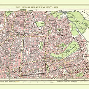
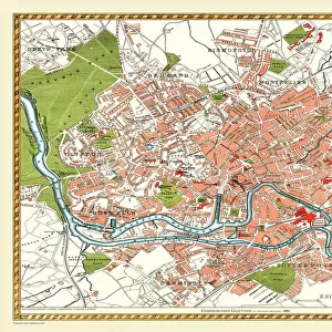
Poster Print : Old Street Map of The Isle of Dogs and River Thames at Greenwich 1908


![]()
Poster Prints from MapSeeker
Old Street Map of The Isle of Dogs and River Thames at Greenwich 1908
Detailed colour Street Plan of London from 1908 covering the area around The Isle of Dogs and The River Thames at Greenwich.The image has been remastered from Bartholomews Handy Atlas of London and Suburbs 1908
Welcome to the Mapseeker Image library and enter an historic gateway to one of the largest on-line collections of Historic Maps, Nostalgic Views, Vista's and Panorama's from a World gone by.
Media ID 20347636
© Mapseeker Publishing Ltd, Collins Bartholomew Ltd
London Map London Street Plan Map Of Central London Map Of London Old London Street Map Old Map Of London Central Street Map Of London Street Plan Greenwich Isle Of Dogs
18x24 inch Poster Print
Discover the rich history of London's past with our Old Street Map of The Isle of Dogs and River Thames at Greenwich 1908 by John Bartholomew. Part of the exclusive Media Storehouse range of poster prints from MapSeeker Publishing, this detailed and colourful representation of the area around The Isle of Dogs and The River Thames at Greenwich is a must-have for history enthusiasts and London lovers alike. Originally featured in Bartholomew's Handy Atlas of London, this vintage map has been carefully remastered to bring out the intricate details of London's streets and waterways from over a century ago. Step back in time and explore the changes that have taken place in this iconic city, all while adding a touch of nostalgia to your home or office. Brought to you by Collins Bartholomew, the renowned name in cartography, this poster print is a beautiful and informative addition to any space. Don't miss out on this unique piece of London's history - order your Old Street Map of The Isle of Dogs and River Thames at Greenwich 1908 today.
Poster prints are budget friendly enlarged prints in standard poster paper sizes. Printed on 150 gsm Matte Paper for a natural feel and supplied rolled in a tube. Great for framing and should last many years. To clean wipe with a microfiber, non-abrasive cloth or napkin. Our Archival Quality Photo Prints and Fine Art Paper Prints are printed on higher quality paper and the choice of which largely depends on your budget.
Poster prints are budget friendly enlarged prints in standard poster paper sizes (A0, A1, A2, A3 etc). Whilst poster paper is sometimes thinner and less durable than our other paper types, they are still ok for framing and should last many years. Our Archival Quality Photo Prints and Fine Art Paper Prints are printed on higher quality paper and the choice of which largely depends on your budget.
Estimated Product Size is 46.3cm x 61.6cm (18.2" x 24.3")
These are individually made so all sizes are approximate
Artwork printed orientated as per the preview above, with portrait (vertical) orientation to match the source image.
FEATURES IN THESE COLLECTIONS
> MapSeeker
> British Town And City Plans
> English & Welsh PORTFOLIO
> Arts
> Photorealistic artworks
> Detailed art pieces
> Masterful detailing in art
> Europe
> United Kingdom
> England
> London
> Boroughs
> Greenwich
> Europe
> United Kingdom
> England
> London
> River Thames
> Europe
> United Kingdom
> England
> London
> Towns
> Greenwich
> Europe
> United Kingdom
> England
> London
> Towns
> Isle of Dogs
EDITORS COMMENTS
This print takes us back in time to the bustling streets of London in 1908. The old street map of The Isle of Dogs and River Thames at Greenwich provides a detailed glimpse into the city's rich history. Remastered from Bartholomews Handy Atlas, this vibrant image showcases the intricate network of roads, buildings, and landmarks that once defined this area. As we explore the map, we are transported to a bygone era where horse-drawn carriages traversed cobblestone streets and gas lamps illuminated the way. Every corner is filled with fascinating details, capturing the essence of life in early 20th century London. The Isle of Dogs stands out as a hub of activity with its thriving docks and industrial sites. Meanwhile, along the meandering River Thames at Greenwich, we can imagine majestic ships sailing past iconic landmarks such as Cutty Sark and Greenwich Park. John Bartholomew's expertise shines through in this meticulously crafted street plan. Collins BartholomewMapseeker Publishing has done an exceptional job remastering this piece of history for all to enjoy. Whether you're a history enthusiast or simply intrigued by London's past, this old street map offers a unique perspective on how much our beloved city has evolved over time. It serves as a reminder that beneath today's modern metropolis lies layers upon layers of stories waiting to be discovered.
MADE IN THE USA
Safe Shipping with 30 Day Money Back Guarantee
FREE PERSONALISATION*
We are proud to offer a range of customisation features including Personalised Captions, Color Filters and Picture Zoom Tools
SECURE PAYMENTS
We happily accept a wide range of payment options so you can pay for the things you need in the way that is most convenient for you
* Options may vary by product and licensing agreement. Zoomed Pictures can be adjusted in the Cart.