Photographic Print > Aerial Photography > Related Images
Photographic Print : Overland Park Kansas US City Street Map

![]()
Photo Prints from Fine Art Storehouse
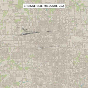
Overland Park Kansas US City Street Map
Vector Illustration of a City Street Map of Overland Park, Kansas, USA. Scale 1:60, 000.
All source data is in the public domain.
U.S. Geological Survey, US Topo
Used Layers:
USGS The National Map: National Hydrography Dataset (NHD)
USGS The National Map: National Transportation Dataset (NTD)
Unleash your creativity and transform your space into a visual masterpiece!
Frank Ramspott
Media ID 15215794
© Frank Ramspott, all rights reserved
Aerial View City Map Computer Graphic Directly Above Downtown District Gray Kansas Road Map Text Digitally Generated Image Green Color White Color
10"x10" Photo Print
Discover the charm of Overland Park, Kansas with our stunning photographic print from Media Storehouse's Fine Art collection. This exquisite piece, titled "Overland Park Kansas US City Street Map" by Frank Ramspott, showcases a vector illustration of the city's street map. With a meticulous scale of 1:60,000 and all source data in the public domain from the U.S, this print is not only an accurate representation but also a beautiful work of art. Bring the unique blend of history and modernity that Overland Park offers right into your home or office space. Order now and let this print add character to your décor.
Photo prints are produced on Kodak professional photo paper resulting in timeless and breath-taking prints which are also ideal for framing. The colors produced are rich and vivid, with accurate blacks and pristine whites, resulting in prints that are truly timeless and magnificent. Whether you're looking to display your prints in your home, office, or gallery, our range of photographic prints are sure to impress. Dimensions refers to the size of the paper in inches.
Our Photo Prints are in a large range of sizes and are printed on Archival Quality Paper for excellent colour reproduction and longevity. They are ideal for framing (our Framed Prints use these) at a reasonable cost. Alternatives include cheaper Poster Prints and higher quality Fine Art Paper, the choice of which is largely dependant on your budget.
Estimated Product Size is 25.4cm x 25.4cm (10" x 10")
These are individually made so all sizes are approximate
Artwork printed orientated as per the preview above, with landscape (horizontal) or portrait (vertical) orientation to match the source image.
FEATURES IN THESE COLLECTIONS
> Fine Art Storehouse
> Map
> Street Maps
> Fine Art Storehouse
> Map
> USA Maps
> Aerial Photography
> Related Images
> Animals
> Insects
> Hemiptera
> Green Scale
> Arts
> Contemporary art
> Digital artwork
> Street art
> Arts
> Street art graffiti
> Digital art
> Digital paintings
> Arts
> Street art graffiti
> Digital art
> Vector illustrations
> Maps and Charts
> Geological Map
> Maps and Charts
> Related Images
> North America
> United States of America
> Kansas
> Kansas City
> North America
> United States of America
> Kansas
> Related Images
> North America
> United States of America
> Lakes
> Related Images
EDITORS COMMENTS
This print showcases the intricate details of Overland Park, Kansas, USA. With a scale of 1:60,000, this vector illustration offers a comprehensive city street map that captures the essence of this vibrant urban landscape. The image is digitally generated and expertly designed by Frank Ramspott. The map incorporates various layers from reliable sources such as the U. S. Geological Survey (USGS) and The National Map. These include the National Hydrography Dataset (NHD) and the National Transportation Dataset (NTD), ensuring accuracy in depicting water bodies, transportation routes, streets, and other essential features. From its downtown district to its serene lake and river, every aspect of Overland Park comes to life in this visually striking artwork. The aerial view provides a unique perspective directly above the cityscape while highlighting key landmarks and roadways. The color scheme blends shades of gray with pops of blue, white, and green for enhanced clarity. This print effortlessly combines cartography with computer graphics to create an engaging representation of Overland Park's physical geography. Perfect for enthusiasts or residents alike, this art piece adds sophistication to any space without featuring people or commercial elements. It serves as both an aesthetically pleasing decoration and a functional tool for navigation within this charming Midwestern town.
MADE IN THE USA
Safe Shipping with 30 Day Money Back Guarantee
FREE PERSONALISATION*
We are proud to offer a range of customisation features including Personalised Captions, Color Filters and Picture Zoom Tools
SECURE PAYMENTS
We happily accept a wide range of payment options so you can pay for the things you need in the way that is most convenient for you
* Options may vary by product and licensing agreement. Zoomed Pictures can be adjusted in the Cart.