Photo Mug > North America > United States of America > Wyoming > Cheyenne
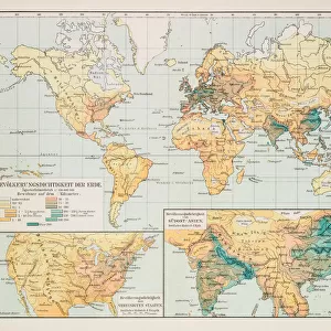
Photo Mug : USA indian territories map 1881


![]()
Home Decor from Fine Art Storehouse
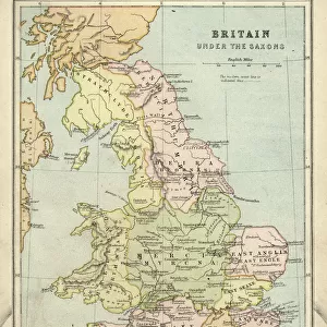
USA indian territories map 1881
Encyclopedia Britannica 9th Edition Vol XII Philadelphia j.M. Stoddart & Co 1881
Unleash your creativity and transform your space into a visual masterpiece!
THEPALMER
Media ID 13611529
© This content is subject to copyright
Paper World Map Cherokee New Territories Wichita
Large Photo Mug (15 oz)
"Bring history to your morning routine with our Media Storehouse Photo Mug featuring the intriguing "USA Indian Territories Map 1881" by THEPALMER from Fine Art Storehouse. This vintage map, originally published in the Encyclopedia Britannica 9th Edition Vol XII Philadelphia j.M. Stoddart & Co 1881, is now transformed into a functional and stylish mug. Each mug is printed with high-quality, vibrant colors and coated for durability, ensuring your favorite beverage stays hot while you explore the fascinating details of this historical map. A perfect gift for history buffs or anyone who appreciates the beauty of classic cartography."
Elevate your coffee or tea experience with our premium white ceramic mug. Its wide, comfortable handle makes drinking easy, and you can rely on it to be both microwave and dishwasher safe. Sold in single units, preview may show both sides of the same mug so you can see how the picture wraps around.
Elevate your coffee or tea experience with our premium white ceramic mug. Its wide, comfortable handle makes drinking easy, and you can rely on it to be both microwave and dishwasher safe. Sold in single units, preview may show both sides of the same mug so you can see how the picture wraps around.
These are individually made so all sizes are approximate
FEATURES IN THESE COLLECTIONS
> Fine Art Storehouse
> The Magical World of Illustration
> Palmer Illustrated Collection
> Fine Art Storehouse
> Map
> Historical Maps
> Fine Art Storehouse
> Map
> USA Maps
> Maps and Charts
> Related Images
> Maps and Charts
> World
> North America
> United States of America
> Maps
> North America
> United States of America
> Wyoming
> Cheyenne
> North America
> United States of America
> Wyoming
> Related Images
EDITORS COMMENTS
This print takes us back in time to the year 1881, showcasing an exquisite map of Indian territories within the United States. A relic from the Encyclopedia Britannica's 9th Edition Volume XII, this piece was published by J. M. Stoddart & Co in Philadelphia. The map itself is a testament to the artistry and precision of cartography during that era. The image depicts a horizontal view of the USA, with particular focus on regions such as Cheyenne Wyoming, New Territories, Wichita, and Cherokee. The intricate details etched onto old paper reveal not only geographical boundaries but also provide insight into physical geography and indigenous populations at that time. An enchanting engraving brings this antique illustration to life, transporting us to an era when maps were meticulously crafted by hand. As we gaze upon this historical artifact, we are reminded of the rich cultural heritage embedded within these lands long before they became states. "The USA Indian Territories Map 1881" serves as a visual portal into America's past - a reminder of its complex history and diverse peoples who once inhabited these lands. This remarkable artwork curated by THEPALMER invites us to reflect on our nation's roots while appreciating the beauty found in vintage cartography.
MADE IN THE USA
Safe Shipping with 30 Day Money Back Guarantee
FREE PERSONALISATION*
We are proud to offer a range of customisation features including Personalised Captions, Color Filters and Picture Zoom Tools
SECURE PAYMENTS
We happily accept a wide range of payment options so you can pay for the things you need in the way that is most convenient for you
* Options may vary by product and licensing agreement. Zoomed Pictures can be adjusted in the Cart.