Metal Print > Europe > United Kingdom > England > Bedfordshire > Bedford
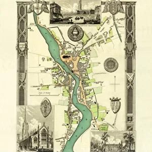
Metal Print : Old Map of Bedford 1807 by Cole and Roper


![]()
Metal Prints from MapSeeker
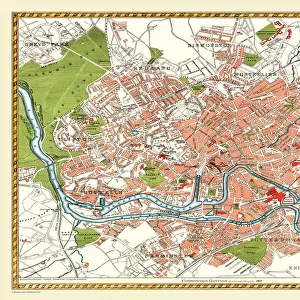
Old Map of Bedford 1807 by Cole and Roper
An attractive and detailed early 19th century reproduction town plan of Bedford, Bedfordshire. First published by Cole and Roper as a finely engraved series of county maps and town plans which were initially issued in parts and then together as The British Atlas in 1810
Welcome to the Mapseeker Image library and enter an historic gateway to one of the largest on-line collections of Historic Maps, Nostalgic Views, Vista's and Panorama's from a World gone by.
Media ID 20348086
© Mapseeker Publishing Ltd
Cole And Roper Historic Map Old Town Plan Town Plan Bedford
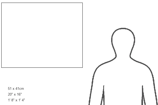
16"x20" (51x41cm) Metal Print
Step back in time with our exquisite Metal Print of the Old Map of Bedford 1807 by Cole and Roper from MapSeeker. This captivating reproduction showcases an early 19th century town plan of Bedford, Bedfordshire, meticulously engraved by Cole and Roper. Add a touch of history and character to your space with this intricately detailed and attractive metal print, perfect for those who appreciate the beauty of antique maps and the rich history they represent.
Made with durable metal and luxurious printing techniques, our metal photo prints go beyond traditional canvases, adding a cool, modern touch to your space. Wall mount on back. Eco-friendly 100% post-consumer recycled ChromaLuxe aluminum surface. The thickness of the print is 0.045". Featuring a Scratch-resistant surface and Rounded corners. Backing hangers are attached to the back of the print and float the print 1/2-inch off the wall when hung, the choice of hanger may vary depending on size and International orders will come with Float Mount hangers only. Finished with a brilliant white high gloss surface for unsurpassed detail and vibrance. Printed using Dye-Sublimation and for best care we recommend a non-ammonia glass cleaner, water, or isopropyl (rubbing) alcohol to prevent harming the print surface. We recommend using a clean, lint-free cloth to wipe off the print. The ultra-hard surface is scratch-resistant, waterproof and weatherproof. Avoid direct sunlight exposure.
Made with durable metal and luxurious printing techniques, metal prints bring images to life and add a modern touch to any space
Estimated Image Size (if not cropped) is 50.8cm x 40.6cm (20" x 16")
Estimated Product Size is 51.4cm x 41.2cm (20.2" x 16.2")
These are individually made so all sizes are approximate
Artwork printed orientated as per the preview above, with landscape (horizontal) orientation to match the source image.
FEATURES IN THESE COLLECTIONS
> MapSeeker
> British Town And City Plans
> English & Welsh PORTFOLIO
> Arts
> Photorealistic artworks
> Detailed art pieces
> Masterful detailing in art
> Europe
> United Kingdom
> England
> Bedfordshire
> Bedford
> Europe
> United Kingdom
> England
> Bedfordshire
> Related Images
> Maps and Charts
> Early Maps
EDITORS COMMENTS
This print showcases an exquisite reproduction of the "Old Map of Bedford 1807" by Cole and Roper. Dating back to the early 19th century, this town plan provides a fascinating glimpse into the historic landscape of Bedford, Bedfordshire. With its intricate details and attractive design, this map offers a window into the past, allowing us to explore the streets and landmarks that shaped this charming town centuries ago. Originally published as part of a finely engraved series of county maps and town plans by Cole and Roper, it later became part of The British Atlas in 1810. The careful craftsmanship evident in every line and curve on this old map reflects both the dedication of its creators and their commitment to accuracy. As we study each street name, building outline, and open space depicted on this piece of history, we can't help but feel transported back in time. Bedford's rich heritage is beautifully preserved within these faded ink lines. This remarkable artifact serves as a testament to our enduring fascination with cartography and our desire to understand how places have evolved over time. Whether you are a history enthusiast or simply captivated by vintage aesthetics, this old map print is sure to be an intriguing addition to any collection or display. It allows us not only to appreciate the beauty found within historical maps but also encourages us to reflect upon how much has changed since Cole and Roper first brought their vision for Bedford's town plan into existence.
MADE IN THE USA
Safe Shipping with 30 Day Money Back Guarantee
FREE PERSONALISATION*
We are proud to offer a range of customisation features including Personalised Captions, Color Filters and Picture Zoom Tools
SECURE PAYMENTS
We happily accept a wide range of payment options so you can pay for the things you need in the way that is most convenient for you
* Options may vary by product and licensing agreement. Zoomed Pictures can be adjusted in the Cart.