Metal Print > North America > United States of America > New York > New York > Maps
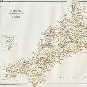
Metal Print : Cornwall map 1884


Metal Prints from Fine Art Storehouse
Cornwall map 1884
Encyclopedia Britannica 9th Edition New York Charles Scribners and Sons 1884 Vol VI
Unleash your creativity and transform your space into a visual masterpiece!
THEPALMER
Media ID 14549439
© This content is subject to copyright
16"x20" (51x41cm) Metal Print
Discover the captivating charm of the past with our Media Storehouse Metal Print featuring a vintage Cornwall map from THEPALMER's 1884 edition in the Encyclopedia Britannica. This exquisite piece, taken from the 9th Edition published by Charles Scribner's Sons in New York, showcases intricate cartographic details of this beautiful region. Our high-quality Metal Prints bring your chosen image to life, adding depth and dimension with their vibrant colors and sleek, modern design. Perfect for adding a touch of historical character to any space, this unique and captivating piece is sure to be a conversation starter. Order yours today and step back in time with Media Storehouse.
Made with durable metal and luxurious printing techniques, our metal photo prints go beyond traditional canvases, adding a cool, modern touch to your space. Wall mount on back. Eco-friendly 100% post-consumer recycled ChromaLuxe aluminum surface. The thickness of the print is 0.045". Featuring a Scratch-resistant surface and Rounded corners. Backing hangers are attached to the back of the print and float the print 1/2-inch off the wall when hung, the choice of hanger may vary depending on size and International orders will come with Float Mount hangers only. Finished with a brilliant white high gloss surface for unsurpassed detail and vibrance. Printed using Dye-Sublimation and for best care we recommend a non-ammonia glass cleaner, water, or isopropyl (rubbing) alcohol to prevent harming the print surface. We recommend using a clean, lint-free cloth to wipe off the print. The ultra-hard surface is scratch-resistant, waterproof and weatherproof. Avoid direct sunlight exposure.
Made with durable metal and luxurious printing techniques, metal prints bring images to life and add a modern touch to any space
Estimated Image Size (if not cropped) is 50.3cm x 40.6cm (19.8" x 16")
Estimated Product Size is 51.4cm x 41.2cm (20.2" x 16.2")
These are individually made so all sizes are approximate
Artwork printed orientated as per the preview above, with landscape (horizontal) orientation to match the source image.
FEATURES IN THESE COLLECTIONS
> Fine Art Storehouse
> Map
> Historical Maps
> Fine Art Storehouse
> Top Sellers - Art Prints
> Europe
> United Kingdom
> England
> Cornwall
> Related Images
> Europe
> United Kingdom
> Maps
> Maps and Charts
> Related Images
> North America
> United States of America
> New York
> New York
> Maps
> North America
> United States of America
> New York
> Related Images
> Popular Themes
> Maps and Charts
EDITORS COMMENTS
In this print titled "Cornwall map 1884". THEPALMER takes us on a journey back in time to the enchanting landscapes of Great Britain's Cornwall. The image showcases an exquisite reproduction of a historic map from the Encyclopedia Britannica 9th Edition, published by Charles Scribners and Sons in New York during 1884. The meticulously detailed map transports us to an era when cartography was both art and science. Every contour, river, town, and road is intricately depicted with utmost precision, offering a glimpse into the geographical layout of Cornwall over a century ago. As we explore this vintage masterpiece, we are reminded of the rich history that has shaped this picturesque region. THEPALMER's expertly captured photograph highlights not only the beauty of this antique map but also its significance as a historical artifact. The warm tones and delicate textures bring out every intricate detail, allowing us to appreciate the craftsmanship involved in creating such maps before modern technology revolutionized cartography. Whether you have personal ties to Cornwall or simply admire its natural wonders and cultural heritage, "Cornwall map 1884" serves as a timeless reminder of our connection to the past. It invites us to delve into history while appreciating fine artistry—a perfect addition for any admirer of vintage maps or those seeking inspiration from times gone by.
MADE IN THE USA
Safe Shipping with 30 Day Money Back Guarantee
FREE PERSONALISATION*
We are proud to offer a range of customisation features including Personalised Captions, Color Filters and Picture Zoom Tools
SECURE PAYMENTS
We happily accept a wide range of payment options so you can pay for the things you need in the way that is most convenient for you
* Options may vary by product and licensing agreement. Zoomed Pictures can be adjusted in the Cart.