Framed Print > Arts > Photorealistic artworks > Detailed art pieces > Masterful detailing in art
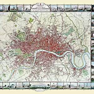
Framed Print : Old Map of Winchester 1805 by Cole and Roper


![]()
Framed Photos from MapSeeker
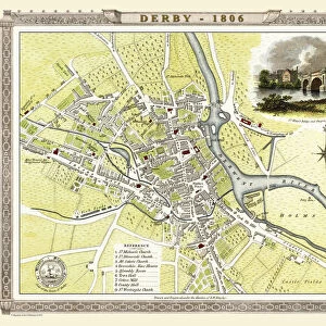
Old Map of Winchester 1805 by Cole and Roper
An attractive and detailed early 19th century reproduction town plan of Winchester 1805. First published by Cole and Roper as a finely engraved series of county maps and town plans which were initially issued in parts and then together as The British Atlas in 1810
Welcome to the Mapseeker Image library and enter an historic gateway to one of the largest on-line collections of Historic Maps, Nostalgic Views, Vista's and Panorama's from a World gone by.
Media ID 20348134
© Mapseeker Publishing Ltd
Cole And Roper Historic Map Old Town Plan Winchester
12"x10" Modern Frame
Discover the rich history of Winchester with our stunning Framed Print of the Old Map of Winchester 1805 by Cole and Roper from MapSeeker. This attractive and intricately detailed reproduction showcases an early 19th century town plan of Winchester, first published by Cole and Roper as a finely engraved series of county maps. Bring a piece of historical charm into your home or office with this beautiful and authentic-looking print, sure to make a statement. Perfect for history enthusiasts, map collectors, or anyone who appreciates the beauty of historical cartography. Order yours today and travel back in time.
10x8 Print in an MDF Wooden Frame with 180 gsm Satin Finish Paper. Glazed using shatter proof thin plexi glass. Frame thickness is 1 inch and depth 0.75 inch. Fluted cardboard backing held with clips. Supplied ready to hang with sawtooth hanger and rubber bumpers. Spot clean with a damp cloth. Packaged foam wrapped in a card.
Contemporary Framed and Mounted Prints - Professionally Made and Ready to Hang
Estimated Image Size (if not cropped) is 25.4cm x 25.4cm (10" x 10")
Estimated Product Size is 25.4cm x 30.5cm (10" x 12")
These are individually made so all sizes are approximate
Artwork printed orientated as per the preview above, with landscape (horizontal) or portrait (vertical) orientation to match the source image.
FEATURES IN THESE COLLECTIONS
> Arts
> Photorealistic artworks
> Detailed art pieces
> Masterful detailing in art
> Maps and Charts
> Early Maps
> MapSeeker
> British Town And City Plans
> English & Welsh PORTFOLIO
EDITORS COMMENTS
This print showcases an exquisite reproduction of the "Old Map of Winchester 1805" by Cole and Roper. Dating back to the early 19th century, this town plan offers a fascinating glimpse into the historic city of Winchester. With its intricate details and attractive design, this map provides a window into the past, allowing us to explore Winchester as it stood over two centuries ago. Originally published as part of a meticulously engraved series of county maps and town plans, this particular piece was later included in The British Atlas in 1810. As we delve into this old map, we discover the streets and landmarks that shaped Winchester's landscape during that era. From bustling marketplaces to grand cathedrals, every corner is carefully depicted with precision and artistry. The charm lies not only in its historical significance but also in its aesthetic appeal. This print captures the essence of a bygone era while serving as a testament to Cole and Roper's skillful craftsmanship. Whether you are an avid history enthusiast or simply appreciate fine cartography, this print will transport you back in time to experience Winchester's rich heritage firsthand. Let yourself be captivated by the allure of this old town plan – an enchanting piece that seamlessly blends art with history.
MADE IN THE USA
Safe Shipping with 30 Day Money Back Guarantee
FREE PERSONALISATION*
We are proud to offer a range of customisation features including Personalised Captions, Color Filters and Picture Zoom Tools
SECURE PAYMENTS
We happily accept a wide range of payment options so you can pay for the things you need in the way that is most convenient for you
* Options may vary by product and licensing agreement. Zoomed Pictures can be adjusted in the Cart.