Framed Print > Arts > Artists > I > Samuel Ireland
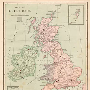
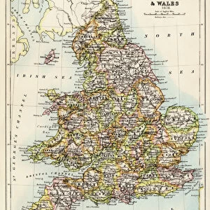
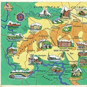
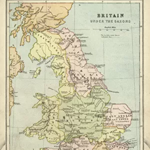
Framed Print : Great Britain and England map 1895


![]()
Framed Photos from Fine Art Storehouse
Great Britain and England map 1895
Encyclopedia Britannica 9th Edition Vol I New York, Samuel Hall 1878
Unleash your creativity and transform your space into a visual masterpiece!
THEPALMER
Media ID 13609245
© This content is subject to copyright
12"x10" Modern Frame
Travel back in time with our exquisite framed print of "Great Britain and England Map 1895" from THEPALMER's collection at Media Storehouse. This antique map, inspired by the Encyclopedia Britannica 9th Edition Vol I published in New York in 1878 by Samuel Hall, is a stunning addition to any home or office. The intricate details and beautiful color palette transport you to a bygone era, making it a perfect conversation starter. Bring history to life with this unique piece of art.
10x8 Print in an MDF Wooden Frame with 180 gsm Satin Finish Paper. Glazed using shatter proof thin plexi glass. Frame thickness is 1 inch and depth 0.75 inch. Fluted cardboard backing held with clips. Supplied ready to hang with sawtooth hanger and rubber bumpers. Spot clean with a damp cloth. Packaged foam wrapped in a card.
Contemporary Framed and Mounted Prints - Professionally Made and Ready to Hang
Estimated Image Size (if not cropped) is 25.4cm x 25.4cm (10" x 10")
Estimated Product Size is 25.4cm x 30.5cm (10" x 12")
These are individually made so all sizes are approximate
Artwork printed orientated as per the preview above, with landscape (horizontal) or portrait (vertical) orientation to match the source image.
FEATURES IN THESE COLLECTIONS
> Fine Art Storehouse
> Map
> Historical Maps
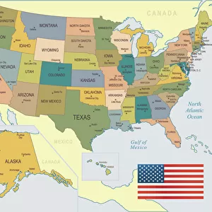
> Fine Art Storehouse
> Map
> USA Maps
> Arts
> Artists
> I
> Samuel Ireland
> Europe
> Republic of Ireland
> Maps
> Europe
> United Kingdom
> England
> Maps
> Europe
> United Kingdom
> England
> York
> Europe
> United Kingdom
> Maps
> Europe
> United Kingdom
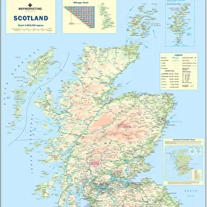
> Scotland
> Maps
> Europe
> United Kingdom
> Scotland
> Posters
> Europe
> United Kingdom
> Scotland
> Related Images
> Maps and Charts
> Related Images
EDITORS COMMENTS
This print takes us back in time to the year 1895, immersing us in the intricate details of a map that once graced the pages of Encyclopedia Britannica's 9th Edition. The map showcases Great Britain and England, capturing their geographical essence with remarkable precision. Crafted by Samuel Hall in New York during an era when cartography was both art and science, this engraving-turned-etching transports us to a world where physical geography was meticulously documented. The lithograph technique employed here adds depth and texture to the illustration, making it all the more enchanting. As we gaze upon this antique masterpiece, our eyes are drawn to every contour and curve of England's coastline, Scotland's majestic highlands, Ireland's lush greenery, and the United Kingdom as a whole. It is as if we can almost feel the history seeping through each line etched onto paper. "ThePalmer" whose name adorns this magnificent work of art from Fine Art Storehouse, has expertly preserved this piece of history for generations to come. This vertical composition invites viewers on a journey through time while simultaneously reminding us of our connection to these lands. Whether you're an avid collector or simply captivated by historical artifacts like this one, let your imagination soar as you explore every inch of this extraordinary map print – a testament to human curiosity and our eternal quest for knowledge about our world.
MADE IN THE USA
Safe Shipping with 30 Day Money Back Guarantee
FREE PERSONALISATION*
We are proud to offer a range of customisation features including Personalised Captions, Color Filters and Picture Zoom Tools
SECURE PAYMENTS
We happily accept a wide range of payment options so you can pay for the things you need in the way that is most convenient for you
* Options may vary by product and licensing agreement. Zoomed Pictures can be adjusted in the Cart.