Framed Print > Aerial Photography > Related Images
Framed Print : Olathe Kansas US City Street Map


![]()
Framed Photos from Fine Art Storehouse
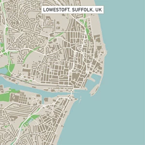
Olathe Kansas US City Street Map
Vector Illustration of a City Street Map of Olathe, Kansas, USA. Scale 1:60, 000.
All source data is in the public domain.
U.S. Geological Survey, US Topo
Used Layers:
USGS The National Map: National Hydrography Dataset (NHD)
USGS The National Map: National Transportation Dataset (NTD)
Unleash your creativity and transform your space into a visual masterpiece!
Frank Ramspott
Media ID 15215790
© Frank Ramspott, all rights reserved
Aerial View City Map Computer Graphic Directly Above Downtown District Gray Kansas Road Map Text Digitally Generated Image Green Color White Color
12"x10" Modern Frame
Discover the charm of Olathe, Kansas with our beautifully framed print from the Media Storehouse collection. This detailed vector illustration of a city street map by Frank Ramspott showcases the US city with a scale of 1:60,000. Each print is meticulously framed, adding an elegant touch to your home or office decor. The map, sourced from the public domain and featuring the finest cartographic detail, makes a perfect gift for those with a love for urban landscapes or a connection to Olathe. Bring a piece of this vibrant city into your space and enjoy the intricate design and historical accuracy of our Fine Art Storehouse framed print.
10x8 Print in an MDF Wooden Frame with 180 gsm Satin Finish Paper. Glazed using shatter proof thin plexi glass. Frame thickness is 1 inch and depth 0.75 inch. Fluted cardboard backing held with clips. Supplied ready to hang with sawtooth hanger and rubber bumpers. Spot clean with a damp cloth. Packaged foam wrapped in a card.
Contemporary Framed and Mounted Prints - Professionally Made and Ready to Hang
Estimated Image Size (if not cropped) is 25.4cm x 25.4cm (10" x 10")
Estimated Product Size is 25.4cm x 30.5cm (10" x 12")
These are individually made so all sizes are approximate
Artwork printed orientated as per the preview above, with landscape (horizontal) or portrait (vertical) orientation to match the source image.
FEATURES IN THESE COLLECTIONS
> Fine Art Storehouse
> Map
> Street Maps
> Fine Art Storehouse
> Map
> USA Maps
> Aerial Photography
> Related Images
> Animals
> Insects
> Hemiptera
> Green Scale
> Arts
> Contemporary art
> Digital artwork
> Street art
> Arts
> Street art graffiti
> Digital art
> Digital paintings
> Arts
> Street art graffiti
> Digital art
> Vector illustrations
> Maps and Charts
> Geological Map
> Maps and Charts
> Related Images
> North America
> United States of America
> Kansas
> Kansas City
> North America
> United States of America
> Kansas
> Related Images
> North America
> United States of America
> Lakes
> Related Images
EDITORS COMMENTS
This print showcases a meticulously detailed city street map of Olathe, Kansas, USA. With a scale of 1:60,000, this vector illustration provides an accurate representation of the city's layout and infrastructure. The artist, Frank Ramspott, has masterfully designed this digitally generated image using various layers from reliable sources such as the U. S. Geological Survey and US Topo. The map incorporates essential elements like downtown districts, lakes, rivers, streets, and roads to offer a comprehensive overview of Olathe's urban landscape. Its vibrant colors - gray for text and buildings, blue for water bodies, white for roads and streets - are visually striking against the green backdrop representing parks or open spaces. With no people in sight but offering an aerial view directly above the cityscape, this print highlights both its physical geography and cartographic excellence. It serves as a valuable resource for locals navigating their way through Olathe or visitors exploring its charming town. As an authentic piece of artwork available at Fine Art Storehouse by Frank Ramspott (not affiliated with any company), this print is not only aesthetically pleasing but also holds historical significance due to its use of public domain source data from USGS The National Map: National Hydrography Dataset (NHD) and National Transportation Dataset (NTD). Whether displayed in homes or offices alike; it adds sophistication while celebrating the beauty of Olathe's urban planning.
MADE IN THE USA
Safe Shipping with 30 Day Money Back Guarantee
FREE PERSONALISATION*
We are proud to offer a range of customisation features including Personalised Captions, Color Filters and Picture Zoom Tools
SECURE PAYMENTS
We happily accept a wide range of payment options so you can pay for the things you need in the way that is most convenient for you
* Options may vary by product and licensing agreement. Zoomed Pictures can be adjusted in the Cart.