Framed Print > North America > United States of America > New York > New York > Maps
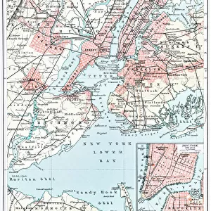
Framed Print : NYC Region and Long Island Map


![]()
Framed Photos from Fine Art Storehouse
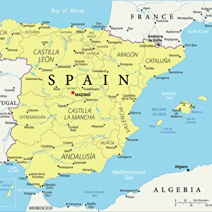
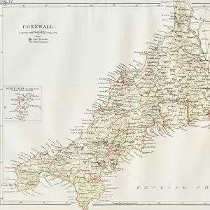
NYC Region and Long Island Map
A map of the region around New York City and Long Island, including New Jersey and the coast of Connecticut. Includes major highways, cities, and lakes
Unleash your creativity and transform your space into a visual masterpiece!
Media ID 21006797
Long Island New York City New York State Road Map Vector Major Road New York Harbour
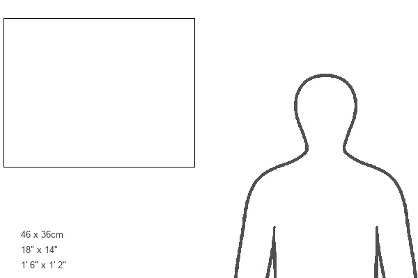
18"x14" Modern Frame
Discover the beauty and complexity of the New York City region and Long Island with our exquisite Framed Print from Media Storehouse's Fine Art Storehouse collection. This stunning map showcases the intricate details of the area, including major highways, cities, and the picturesque coast of Connecticut and New Jersey. Bring a piece of the bustling metropolis into your home or office with this beautifully designed and expertly crafted framed print. Perfect for those who appreciate the elegance of fine art and the allure of the Northeast, this map is sure to make a captivating conversation starter. Add it to your collection today and let the adventure begin.
16x12 Print in an MDF Wooden Frame with 180 gsm Satin Finish Paper. Glazed using shatter proof thin plexiglass. Frame thickness is 1 inch and depth 0.75 inch. Fluted cardboard backing held with clips. Supplied ready to hang with sawtooth hanger and rubber bumpers. Spot clean with a damp cloth. Packaged foam wrapped in a card.
Contemporary Framed and Mounted Prints - Professionally Made and Ready to Hang
Estimated Image Size (if not cropped) is 40.6cm x 35.6cm (16" x 14")
Estimated Product Size is 45.7cm x 35.6cm (18" x 14")
These are individually made so all sizes are approximate
Artwork printed orientated as per the preview above, with landscape (horizontal) orientation to match the source image.
FEATURES IN THESE COLLECTIONS
> Fine Art Storehouse
> Map
> Historical Maps
> Maps and Charts
> Related Images
> North America
> United States of America
> Connecticut
> Related Images
> North America
> United States of America
> Lakes
> Related Images
> North America
> United States of America
> Maps
> North America
> United States of America
> New Jersey
> Jersey City
> North America
> United States of America
> New Jersey
> Related Images
> North America
> United States of America
> New York
> New York
> Maps
> North America
> United States of America
> New York
> Related Images
EDITORS COMMENTS
This print showcases the intricate and expansive web of roads, cities, and natural features that make up the vibrant NYC Region and Long Island. With meticulous detail, this map encompasses not only New York City itself but also stretches across neighboring states such as New Jersey and Connecticut. The viewer is immediately drawn to the prominent highways that crisscross the region like lifelines connecting bustling urban centers. These major arteries serve as vital conduits for transportation, facilitating movement between cities while symbolizing the constant flow of life in this dynamic area. From a bird's-eye perspective, one can appreciate how this map encapsulates both man-made marvels and natural wonders. The sprawling metropolis of New York City stands out with its iconic skyline dominating the landscape, juxtaposed against serene lakes dotting the countryside. While devoid of human presence, this illustration exudes an energy that captures the essence of a thriving region constantly on-the-go. It serves as a reminder of how interconnected our world has become through modern infrastructure and transportation systems. Whether you are an avid traveler or simply fascinated by geography, this vector-based artwork offers an opportunity to explore every nook and cranny of this diverse region from afar. A perfect addition to any collection or space seeking to evoke a sense of wonderment about one of America's most influential hubs - without mentioning commercial use!
MADE IN THE USA
Safe Shipping with 30 Day Money Back Guarantee
FREE PERSONALISATION*
We are proud to offer a range of customisation features including Personalised Captions, Color Filters and Picture Zoom Tools
SECURE PAYMENTS
We happily accept a wide range of payment options so you can pay for the things you need in the way that is most convenient for you
* Options may vary by product and licensing agreement. Zoomed Pictures can be adjusted in the Cart.