Framed Print > North America > United States of America > New York > New York > Maps
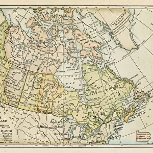
Framed Print : Map of Canada 1878


![]()
Framed Photos from Fine Art Storehouse
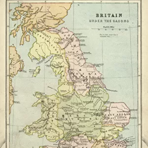
Map of Canada 1878
Encyclopedia Britannica 9th Edition Vol II New York, Samuel Hall 1878
Unleash your creativity and transform your space into a visual masterpiece!
THEPALMER
Media ID 13609291
© This content is subject to copyright
12"x10" Modern Frame
Step back in time with our exquisite Framed Print of "Map of Canada 1878" by THEPALMER from the Media Storehouse Fine Art Storehouse collection. This captivating vintage map, originally published in the Encyclopedia Britannica 9th Edition Vol II, New York, 1878, showcases the historical geography of Canada during a pivotal period in its history. The intricate details and beautiful antique aesthetic are sure to make this print a stunning addition to any home or office. Bring a piece of history into your space and elevate your decor with this beautifully framed Map of Canada 1878.
10x8 Print in an MDF Wooden Frame with 180 gsm Satin Finish Paper. Glazed using shatter proof thin plexi glass. Frame thickness is 1 inch and depth 0.75 inch. Fluted cardboard backing held with clips. Supplied ready to hang with sawtooth hanger and rubber bumpers. Spot clean with a damp cloth. Packaged foam wrapped in a card.
Contemporary Framed and Mounted Prints - Professionally Made and Ready to Hang
Estimated Image Size (if not cropped) is 25.4cm x 25.4cm (10" x 10")
Estimated Product Size is 30.5cm x 25.4cm (12" x 10")
These are individually made so all sizes are approximate
Artwork printed orientated as per the preview above, with landscape (horizontal) or portrait (vertical) orientation to match the source image.
FEATURES IN THESE COLLECTIONS
> Fine Art Storehouse
> Map
> Historical Maps
> Maps and Charts
> Related Images
> North America
> Canada
> Maps
> North America
> Canada
> Related Images
> North America
> United States of America
> Maps
> North America
> United States of America
> New York
> New York
> Maps
> North America
> United States of America
> New York
> Related Images
EDITORS COMMENTS
In this print titled "Map of Canada 1878" we are transported back in time to the late 19th century, where cartography was a meticulous art form. This particular piece is sourced from the Encyclopedia Britannica's 9th Edition Volume II, published in New York by Samuel Hall in 1878. The map itself is an exquisite example of engraving and etching techniques, showcasing the intricate details that were painstakingly crafted by skilled artisans. As we gaze upon it, we can't help but marvel at its beauty and historical significance. This antique lithograph offers us a glimpse into Canada's past, revealing not only its geographical features but also providing insight into the country's physical geography during that era. The borders of Canada stretch across the image horizontally while neighboring regions such as the United States and North America are also depicted. As collectors or enthusiasts of old maps would appreciate, this print holds immense value beyond its aesthetic appeal. It serves as a visual testament to how our understanding of geography has evolved over time and reminds us of the importance placed on accurately documenting our world. "The Map of Canada 1878" by THEPALMER invites us to explore history through artistry—a timeless reminder that even within seemingly mundane objects like maps lies a wealth of knowledge waiting to be discovered.
MADE IN THE USA
Safe Shipping with 30 Day Money Back Guarantee
FREE PERSONALISATION*
We are proud to offer a range of customisation features including Personalised Captions, Color Filters and Picture Zoom Tools
SECURE PAYMENTS
We happily accept a wide range of payment options so you can pay for the things you need in the way that is most convenient for you
* Options may vary by product and licensing agreement. Zoomed Pictures can be adjusted in the Cart.