Canvas Print > North America > United States of America > New York > New York > Maps
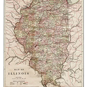
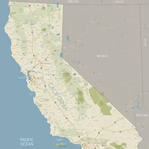
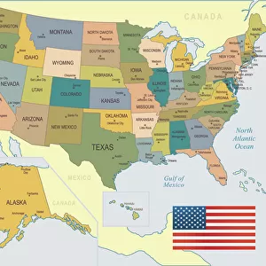
Canvas Print : Map of California 1878


![]()
Canvas Prints From Fine Art Storehouse
Map of California 1878
Encyclopedia Britannica 9th Edition Vol II New York, Samuel Hall 1878
Unleash your creativity and transform your space into a visual masterpiece!
THEPALMER
Media ID 13609285
© This content is subject to copyright
20"x16" (51x41cm) Canvas Print
"Step back in time with our exquisite Canvas Print of "Map of California 1878" by THEPALMER from our Media Storehouse collection. This stunning reproduction is taken from the Encyclopedia Britannica 9th Edition Vol II published in New York, 1878 by Samuel Hall. The intricate details of this vintage map are brought to life with our premium canvas printing process, creating a vibrant and textured piece that adds an air of history and sophistication to any room. Hang it in your office, living room, or library to start conversations and inspire curiosity. Transport yourself back to a time of exploration and discovery with this beautiful and authentic work of art."
Delivered stretched and ready to hang our premium quality canvas prints are made from a polyester/cotton blend canvas and stretched over a 1.25" (32mm) kiln dried knot free wood stretcher bar. Packaged in a plastic bag and secured to a cardboard insert for safe transit.
Canvas Prints add colour, depth and texture to any space. Professionally Stretched Canvas over a hidden Wooden Box Frame and Ready to Hang
Estimated Product Size is 40.6cm x 50.8cm (16" x 20")
These are individually made so all sizes are approximate
Artwork printed orientated as per the preview above, with portrait (vertical) orientation to match the source image.
FEATURES IN THESE COLLECTIONS
> Animals
> Mammals
> Cricetidae
> California Mouse
> Maps and Charts
> Related Images
> North America
> United States of America
> California
> Related Images
> North America
> United States of America
> Maps
> North America
> United States of America
> New York
> New York
> Maps
> North America
> United States of America
> New York
> Related Images
> Fine Art Storehouse
> Map
> Historical Maps
> Fine Art Storehouse
> Map
> USA Maps
EDITORS COMMENTS
This print showcases a remarkable piece of history - the "Map of California 1878" from the Encyclopedia Britannica's 9th Edition. Published in New York by Samuel Hall in the year 1878, this antique map offers a fascinating glimpse into the past. The vertical composition allows us to fully appreciate every intricate detail engraved and etched onto its surface. The artistry involved in creating this lithograph is truly commendable. The cartography skills employed here are exceptional, as each contour and boundary is meticulously illustrated with precision and accuracy. This old-world charm exudes an air of nostalgia that transports us back to a time when physical geography was painstakingly documented by hand. As we delve deeper into this mesmerizing map, we witness California taking center stage within North America's Pacific states. Its borders elegantly outlined, revealing both coastal beauty and inland wonders. From majestic mountain ranges to winding rivers, from sprawling cities to quaint towns - every feature on this map tells a story of exploration and discovery. "The Map of California 1878" by THEPALMER captures our imagination with its vintage allure and historical significance. It serves as a testament to human curiosity about our surroundings and how far we have come in understanding our world since then. Whether displayed at home or in an educational setting, this enchanting print invites us to embark on a journey through time while appreciating the artistry behind cartography's golden age.
MADE IN THE USA
Safe Shipping with 30 Day Money Back Guarantee
FREE PERSONALISATION*
We are proud to offer a range of customisation features including Personalised Captions, Color Filters and Picture Zoom Tools
SECURE PAYMENTS
We happily accept a wide range of payment options so you can pay for the things you need in the way that is most convenient for you
* Options may vary by product and licensing agreement. Zoomed Pictures can be adjusted in the Basket.