Canvas Print > Aerial Photography > Related Images
Canvas Print : Bellevue Nebraska US City Street Map


![]()
Canvas Prints from Fine Art Storehouse
Bellevue Nebraska US City Street Map
Vector Illustration of a City Street Map of Bellevue, Nebraska, USA. Scale 1:60, 000.
All source data is in the public domain.
U.S. Geological Survey, US Topo
Used Layers:
USGS The National Map: National Hydrography Dataset (NHD)
USGS The National Map: National Transportation Dataset (NTD)
Unleash your creativity and transform your space into a visual masterpiece!
Frank Ramspott
Media ID 15192910
© Frank Ramspott, all rights reserved
Aerial View City Map Computer Graphic Directly Above Downtown District Gray Nebraska Road Map Text Bellevue Digitally Generated Image Green Color White Color
20"x16" (51x41cm) Canvas Print
Discover the charm of Bellevue, Nebraska with our stunning Canvas Print of the city street map by Frank Ramspott from Media Storehouse's Fine Art Storehouse collection. This exquisite vector illustration, featuring a 1:60,000 scale City Street Map of Bellevue, USA, is meticulously crafted from public domain source data. Each detail, from the winding roads to the intricate building outlines, is rendered with the utmost precision and care. Bring the history and character of this vibrant American city into your home or office with this beautiful and unique piece of art. Order your Bellevue Nebraska City Street Map Canvas Print today and let the story of this fascinating place unfold before your eyes.
Delivered stretched and ready to hang our premium quality canvas prints are made from a polyester/cotton blend canvas and stretched over a 1.25" (32mm) kiln dried knot free wood stretcher bar. Packaged in a plastic bag and secured to a cardboard insert for safe transit.
Canvas Prints add colour, depth and texture to any space. Professionally Stretched Canvas over a hidden Wooden Box Frame and Ready to Hang
Estimated Product Size is 40.6cm x 50.8cm (16" x 20")
These are individually made so all sizes are approximate
Artwork printed orientated as per the preview above, with portrait (vertical) orientation to match the source image.
FEATURES IN THESE COLLECTIONS
> Aerial Photography
> Related Images
> Animals
> Insects
> Hemiptera
> Green Scale
> Arts
> Contemporary art
> Digital artwork
> Street art
> Arts
> Street art graffiti
> Digital art
> Digital paintings
> Arts
> Street art graffiti
> Digital art
> Vector illustrations
> Maps and Charts
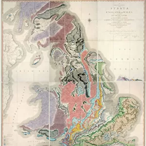
> Geological Map
> Maps and Charts
> Related Images
> North America
> United States of America
> Lakes
> Related Images
> North America
> United States of America
> Maps
> North America
> United States of America
> Nebraska
> Related Images
> Fine Art Storehouse
> Map
> Street Maps
> Fine Art Storehouse
> Map
> USA Maps
EDITORS COMMENTS
This print showcases a meticulously detailed city street map of Bellevue, Nebraska, USA. The vector illustration captures the essence of this charming town with its downtown district, serene lake, and meandering river. With a scale of 1:60,000, every road and street is clearly depicted in this visually stunning artwork. The source data used to create this masterpiece is all in the public domain and comes from reputable sources such as the U. S. Geological Survey (USGS) and US Topo. Specifically, the USGS National Map provided valuable information from their National Hydrography Dataset (NHD) and National Transportation Dataset (NTD), ensuring accuracy and precision. Designed by Frank Ramspott using computer graphics techniques, this digitally generated image offers an aerial view directly above Bellevue's landscape. The color palette chosen for this artwork includes shades of gray, blue, white, and green - perfectly capturing the physical geography of the area. With no people present in the image itself but featuring text labels for easy navigation reference points throughout Bellevue's streetscape – this print serves as both a functional road map and a beautiful piece of cartography art. Whether you're a resident or visitor to Bellevue or simply appreciate fine art that combines design with practicality – this print is sure to captivate your imagination while providing valuable insights into navigating the city streets.
MADE IN THE USA
Safe Shipping with 30 Day Money Back Guarantee
FREE PERSONALISATION*
We are proud to offer a range of customisation features including Personalised Captions, Color Filters and Picture Zoom Tools
SECURE PAYMENTS
We happily accept a wide range of payment options so you can pay for the things you need in the way that is most convenient for you
* Options may vary by product and licensing agreement. Zoomed Pictures can be adjusted in the Cart.