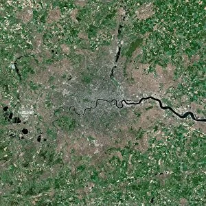
Photographic Print > Europe > United Kingdom > England > London > Boroughs > Greenwich
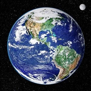
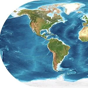
Photographic Print : Whole Earth, satellite image


![]()
Photo Prints from Science Photo Library
Whole Earth, satellite image
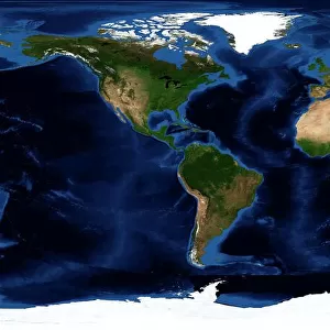
Whole Earth, satellite image. This map is centred on the Greenwich meridian, at zero degrees latitude. Arctic and Antarctic ice is white, oceans are blue and land is green and brown. This image was produced by combining data from the Defense Meteorological Satellite Program (DMSP) and NOas POES and Nimbus 7 satellites
Science Photo Library features Science and Medical images including photos and illustrations
Media ID 1705095
© PLANETARY VISIONS LTD/SCIENCE PHOTO LIBRARY
Combined Data Continent Continents Day Time Defense Meteorological Dmsp Earth Observation Earth Science From Space Global Globe Hemisphere Land Land Cover Nimbus 7 Noaa Poes Polar Orbiter Satellite Satellite Image Satellite Program Satellites Topographical Topography Vegetation Whole Earth World World Wide
12"x8" Photo Print
Discover the breathtaking view of our planet with Media Storehouse's Photographic Prints featuring the "Whole Earth, Satellite Image" from Science Photo Library. This stunning representation of our world showcases the mesmerizing blend of land, sea, and ice caps in perfect harmony. With intricate details revealing the Greenwich meridian and zero degrees latitude, this print is a captivating reminder of our place in the universe. Order now and bring the wonders of Earth into your home or office.
Photo prints are produced on Kodak professional photo paper resulting in timeless and breath-taking prints which are also ideal for framing. The colors produced are rich and vivid, with accurate blacks and pristine whites, resulting in prints that are truly timeless and magnificent. Whether you're looking to display your prints in your home, office, or gallery, our range of photographic prints are sure to impress. Dimensions refers to the size of the paper in inches.
Our Photo Prints are in a large range of sizes and are printed on Archival Quality Paper for excellent colour reproduction and longevity. They are ideal for framing (our Framed Prints use these) at a reasonable cost. Alternatives include cheaper Poster Prints and higher quality Fine Art Paper, the choice of which is largely dependant on your budget.
Estimated Image Size (if not cropped) is 30.4cm x 15.2cm (12" x 6")
Estimated Product Size is 30.5cm x 20.3cm (12" x 8")
These are individually made so all sizes are approximate
Artwork printed orientated as per the preview above, with landscape (horizontal) orientation to match the source image.
FEATURES IN THESE COLLECTIONS
> Arts
> Artists
> O
> Oceanic Oceanic
> Europe
> France
> Canton
> Landes
> Europe
> United Kingdom
> England
> London
> Boroughs
> Greenwich
> Maps and Charts
> Related Images
> Maps and Charts
> World
> Science
> Space Exploration
> Planets
> Earth
> Science Photo Library
> Aerial and Satellite
EDITORS COMMENTS
This stunning print captures the beauty and complexity of our planet, Earth. Taken from space, this satellite image provides a unique perspective on our world. The map is centered on the Greenwich meridian at zero degrees latitude, showcasing the entire globe in all its glory. The colors in this image are both vibrant and meaningful. The Arctic and Antarctic ice appear as pristine white, representing the frozen regions of our planet. The vast oceans are depicted in varying shades of blue, symbolizing their immense depth and importance to life on Earth. Meanwhile, landmasses are portrayed in green and brown hues, reflecting the diverse vegetation cover across continents. To create this incredible visual representation, data from multiple satellites was combined - specifically from the Defense Meteorological Satellite Program (DMSP), NOas POES (Polar Orbiting Environmental Satellites), and Nimbus 7 satellites. This collaboration allowed for a comprehensive view of Earth's surface features. As we gaze upon this photograph, we can't help but marvel at the intricate details it reveals about our home planet. It serves as a reminder of how interconnected everything is - from land to sea to atmosphere - highlighting the significance of studying Earth science and observing our world from space.
MADE IN THE USA
Safe Shipping with 30 Day Money Back Guarantee
FREE PERSONALISATION*
We are proud to offer a range of customisation features including Personalised Captions, Color Filters and Picture Zoom Tools
SECURE PAYMENTS
We happily accept a wide range of payment options so you can pay for the things you need in the way that is most convenient for you
* Options may vary by product and licensing agreement. Zoomed Pictures can be adjusted in the Cart.