Metal Print > Maps and Charts > Early Maps
Metal Print : Amundsen Voyage Map


![]()
Metal Prints from Mary Evans Picture Library
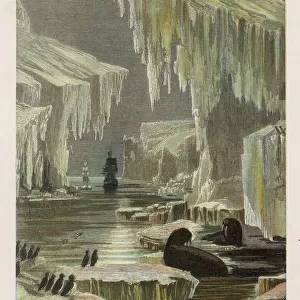
Amundsen Voyage Map
A map showing the route of Amundsens voyage through the North-west Passage
Mary Evans Picture Library makes available wonderful images created for people to enjoy over the centuries
Media ID 4367544
© Mary Evans Picture Library 2015 - https://copyrighthub.org/s0/hub1/creation/maryevans/MaryEvansPictureID/10123682
Amundsen Exploration Passage Polar Route Voyage
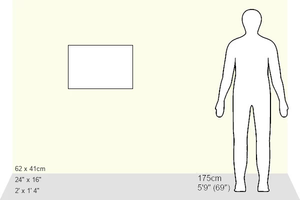
16"x24" (61x41cm) Metal Print
Discover the thrill of polar exploration with our stunning Metal Prints featuring the Amundsen Voyage Map. This captivating image, sourced from Mary Evans Prints Online, showcases the historic route of Roald Amundsen's groundbreaking Northwest Passage voyage. Each Metal Print is meticulously crafted with a vibrant, high-definition image transferred onto a sturdy aluminum sheet, ensuring a long-lasting, waterproof, and scratch-resistant display. Bring the adventure into your home or office and let the intricate details of this iconic map captivate you every day.
Made with durable metal and luxurious printing techniques, our metal photo prints go beyond traditional canvases, adding a cool, modern touch to your space. Wall mount on back. Eco-friendly 100% post-consumer recycled ChromaLuxe aluminum surface. The thickness of the print is 0.045". Featuring a Scratch-resistant surface and Rounded corners. Backing hangers are attached to the back of the print and float the print 1/2-inch off the wall when hung, the choice of hanger may vary depending on size and International orders will come with Float Mount hangers only. Finished with a brilliant white high gloss surface for unsurpassed detail and vibrance. Printed using Dye-Sublimation and for best care we recommend a non-ammonia glass cleaner, water, or isopropyl (rubbing) alcohol to prevent harming the print surface. We recommend using a clean, lint-free cloth to wipe off the print. The ultra-hard surface is scratch-resistant, waterproof and weatherproof. Avoid direct sunlight exposure.
Made with durable metal and luxurious printing techniques, metal prints bring images to life and add a modern touch to any space
Estimated Product Size is 61.5cm x 41.2cm (24.2" x 16.2")
These are individually made so all sizes are approximate
Artwork printed orientated as per the preview above, with landscape (horizontal) orientation to match the source image.
FEATURES IN THESE COLLECTIONS
> Maps and Charts
> Early Maps
> Maps and Charts
> Related Images
EDITORS COMMENTS
This historic map, titled "Amundsen's Voyage through the North-West Passage, 1905," is a testament to the groundbreaking exploration journey led by the renowned Norwegian polar explorer, Roald Amundsen. The map meticulously illustrates the route taken by Amundsen and his crew aboard the Gjøa, the first vessel to navigate the elusive Northwest Passage from east to west, achieving a long-sought goal in the annals of polar exploration. The Northwest Passage, a series of waterways traversing the Arctic Ocean, had long been a subject of fascination and obsession for explorers due to its potential to significantly shorten the sea route between Europe and Asia. However, the treacherous ice and unpredictable weather conditions made it an arduous and dangerous undertaking. Amundsen's successful voyage began on June 16, 1903, when the Gjøa set sail from Norway. The expedition faced numerous challenges, including encounters with treacherous ice floes, harsh weather, and the isolation and hardships of life in the Arctic. Despite these challenges, Amundsen and his crew persevered, and on August 22, 1906, they became the first humans to navigate the Northwest Passage from east to west. This map, produced in 1905, is an essential historical document that charts the route of Amundsen's groundbreaking expedition. It provides a visual representation of the incredible journey that forever changed the world's understanding of the Arctic and the capabilities of human endurance. The intricate details of the map, from the labeled islands and waterways to the notations of key events and locations, offer a fascinating glimpse into the past and the spirit of exploration that continues to inspire us today.
MADE IN THE USA
Safe Shipping with 30 Day Money Back Guarantee
FREE PERSONALISATION*
We are proud to offer a range of customisation features including Personalised Captions, Color Filters and Picture Zoom Tools
SECURE PAYMENTS
We happily accept a wide range of payment options so you can pay for the things you need in the way that is most convenient for you
* Options may vary by product and licensing agreement. Zoomed Pictures can be adjusted in the Cart.