Metal Print > Maps and Charts > World
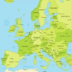
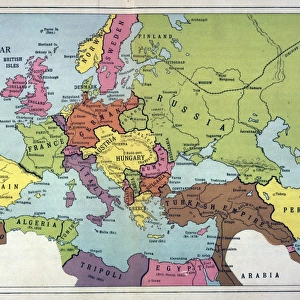
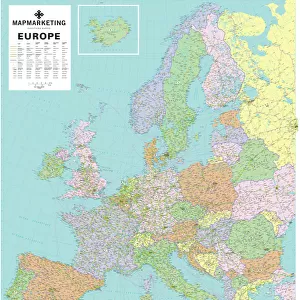
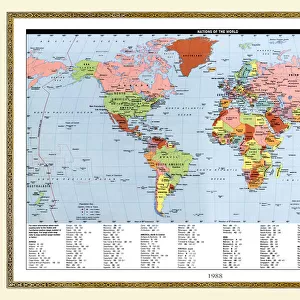
Metal Print : Political map of Europe


Resolution may be reduced at this size (104 DPI)
![]()
Metal Prints from Fine Art Storehouse
Political map of Europe
Vector illustration of the policital map of Europe
Reference map was created by the US Central Intelligence Agency and is available as a public domain map at the University of Texas Libraries website.
https:/cia.gov/library/publications/resources/the-world-factbook/graphics/ref_maps/political/pdf/europe.pdf
Unleash your creativity and transform your space into a visual masterpiece!
Media ID 15192882
20"x24" (61x51cm) Metal Print
Experience the intricacies of European politics brought to life with our Media Storehouse Metal Prints. Featuring a stunning vector illustration of the Political Map of Europe, this fine art piece is a must-have for history enthusiasts and geography aficionados alike. Meticulously crafted from high-quality metal, each print showcases vibrant colors and sharp details, ensuring a captivating display in any home or office setting. The map, created by the US Central Intelligence Agency and available as a public domain map at the University of Texas Libraries, adds an intellectual and sophisticated touch to your decor. Elevate your space with the timeless beauty of our Metal Prints and relish in the rich history and complexity of European politics.
Made with durable metal and luxurious printing techniques, our metal photo prints go beyond traditional canvases, adding a cool, modern touch to your space. Wall mount on back. Eco-friendly 100% post-consumer recycled ChromaLuxe aluminum surface. The thickness of the print is 0.045". Featuring a Scratch-resistant surface and Rounded corners. Backing hangers are attached to the back of the print and float the print 1/2-inch off the wall when hung, the choice of hanger may vary depending on size and International orders will come with Float Mount hangers only. Finished with a brilliant white high gloss surface for unsurpassed detail and vibrance. Printed using Dye-Sublimation and for best care we recommend a non-ammonia glass cleaner, water, or isopropyl (rubbing) alcohol to prevent harming the print surface. We recommend using a clean, lint-free cloth to wipe off the print. The ultra-hard surface is scratch-resistant, waterproof and weatherproof. Avoid direct sunlight exposure.
Made with durable metal and luxurious printing techniques, metal prints bring images to life and add a modern touch to any space
Estimated Image Size (if not cropped) is 50.8cm x 60.9cm (20" x 24")
Estimated Product Size is 51.4cm x 61.5cm (20.2" x 24.2")
These are individually made so all sizes are approximate
Artwork printed orientated as per the preview above, with portrait (vertical) orientation to match the source image.
FEATURES IN THESE COLLECTIONS
> Fine Art Storehouse
> Map
> Reference Maps
> Maps and Charts
> Related Images
> Maps and Charts
> World
EDITORS COMMENTS
This print showcases a meticulously detailed political map of Europe, brought to life through a stunning vector illustration. Every country, border, and major city is intricately depicted, offering an immersive visual experience that invites exploration and discovery. What makes this particular artwork even more fascinating is its reference source. Created by the US Central Intelligence Agency (CIA), this map holds immense credibility and accuracy. The fact that it is available as a public domain map at the University of Texas Libraries website further emphasizes its reliability and accessibility for all knowledge seekers. The beauty of this print lies not only in its aesthetic appeal but also in its educational value. It serves as an invaluable resource for students, researchers, or anyone with an interest in European geography or politics. Whether you're planning your next adventure across the continent or simply expanding your understanding of global affairs, this artwork provides a comprehensive overview of Europe's political landscape. With Fine Art Storehouse bringing this masterpiece to life through their exceptional printing techniques, every intricate detail pops off the page with vibrant colors and sharp lines. This print is perfect for adorning any wall space - be it at home or in an office setting - adding sophistication while simultaneously fostering intellectual curiosity
MADE IN THE USA
Safe Shipping with 30 Day Money Back Guarantee
FREE PERSONALISATION*
We are proud to offer a range of customisation features including Personalised Captions, Color Filters and Picture Zoom Tools
SECURE PAYMENTS
We happily accept a wide range of payment options so you can pay for the things you need in the way that is most convenient for you
* Options may vary by product and licensing agreement. Zoomed Pictures can be adjusted in the Cart.