Framed Print > Arts > Artists > O > Oceanic Oceanic
Framed Print : EXPL2A-00352


Framed Photos from North Wind
EXPL2A-00352
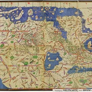
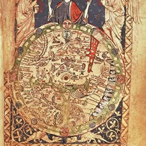
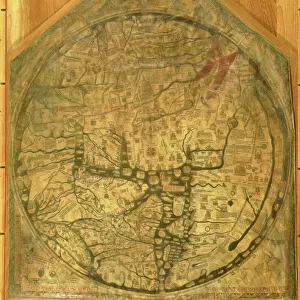
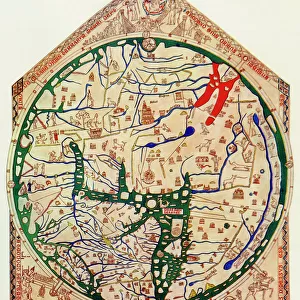
The Hereford Mappa Mundi of 1280 - Jerusalem is at the center, Europe lower left, Africa lower right.
Printed color halftone reproduction 19th century
North Wind Picture Archives brings history to life with stock images and hand-colored illustrations
Media ID 5881938
© North Wind Picture Archives
1200s 13th Century Africa Asia Cartography Document Earth Europe Flat Earth Jerusalem Medieval Mediterranean Mid East Middle Ages Navigation Ocean World World Map 1280 Flat Hereford Mappa Mundi
12"x10" Modern Frame
Introducing the stunning addition to our Framed Prints collection from Media Storehouse - EXPL2A-00352, a captivating image from North Wind Picture Archives. This exquisite print showcases the Hereford Mappa Mundi of 1280, an intricately detailed and historically significant medieval map. The centerpiece of the map is Jerusalem, surrounded by Europe to the left and Africa to the right. This 19th century, printed color halftone reproduction brings the rich history and intricate details of this ancient map to life in your home or office. Experience the allure of the past with this beautiful and educational piece.
10x8 Print in an MDF Wooden Frame with 180 gsm Satin Finish Paper. Glazed using shatter proof thin plexi glass. Frame thickness is 1 inch and depth 0.75 inch. Fluted cardboard backing held with clips. Supplied ready to hang with sawtooth hanger and rubber bumpers. Spot clean with a damp cloth. Packaged foam wrapped in a card.
Contemporary Framed and Mounted Prints - Professionally Made and Ready to Hang
Estimated Image Size (if not cropped) is 22.1cm x 25.4cm (8.7" x 10")
Estimated Product Size is 25.4cm x 30.5cm (10" x 12")
These are individually made so all sizes are approximate
Artwork printed orientated as per the preview above, with portrait (vertical) orientation to match the source image.
FEATURES IN THESE COLLECTIONS
> Arts
> Art Movements
> Medieval Art
> Arts
> Artists
> O
> Oceanic Oceanic
> Maps and Charts
> Flat Earth
> Maps and Charts
> Popular Maps
> Maps and Charts
> Related Images
> Maps and Charts
> World
> Popular Themes
> Maps and Charts
EDITORS COMMENTS
This print showcases the EXPL2A-00352, also known as The Hereford Mappa Mundi of 1280. A true testament to medieval cartography, this vintage reproduction offers a glimpse into the world as it was perceived in the 13th century. At its heart lies Jerusalem, symbolizing its significance during that era. Europe is depicted in the lower left corner, while Africa graces the lower right side of this historic map. Printed with vibrant colors and halftone techniques in the 19th century, this illustration transports us back to a time when navigation relied on such intricate documents. The detailed representation of continents and oceans serves as a reminder of how early civilizations understood their place within the vastness of our planet. The Hereford Mappa Mundi not only provides geographical information but also reflects cultural beliefs prevalent during the Middle Ages. It captures an Earth where Asia stretches eastward towards unknown lands and where mythical creatures roam unexplored territories. As we gaze upon this remarkable piece of artistry, we are reminded of humanity's insatiable curiosity about our world's history and geography. This photograph invites us to appreciate both its aesthetic beauty and historical significance—a tangible connection to an age long past yet still relevant today.
MADE IN THE USA
Safe Shipping with 30 Day Money Back Guarantee
FREE PERSONALISATION*
We are proud to offer a range of customisation features including Personalised Captions, Color Filters and Picture Zoom Tools
SECURE PAYMENTS
We happily accept a wide range of payment options so you can pay for the things you need in the way that is most convenient for you
* Options may vary by product and licensing agreement. Zoomed Pictures can be adjusted in the Cart.