Home > North America > United States of America > Rhode Island > Providence
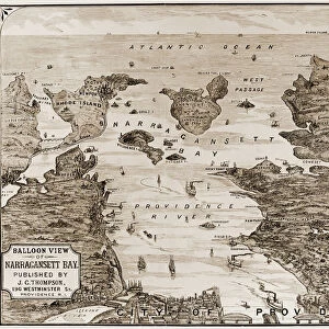
1865 U.S. Coast Survey Map Or Chart Of Providence

![]()
Wall Art and Photo Gifts from Universal Images Group (UIG)
1865 U.S. Coast Survey Map Or Chart Of Providence
1865, U.S. Coast Survey Map or Chart of Providence, Rhode Island
Universal Images Group (UIG) manages distribution for many leading specialist agencies worldwide
Media ID 38549566
© Artokoloro Quint Lox Limited
1865 Rhode Island Antique Map Latitude Longitude Mappa Mundi Old Antique Plan Old Antique View Ols Antique Map Rare Old Maps Topo
FEATURES IN THESE COLLECTIONS
> Europe
> France
> Canton
> Landes
> Historic
> Space exploration
> Maps and Charts
> Early Maps
> Maps and Charts
> Related Images
> Maps and Charts
> World
> North America
> United States of America
> Rhode Island
> Providence
> Universal Images Group (UIG)
> History
> Historical Maps
EDITORS COMMENTS
Step back in time to 1865 and explore the charming city of Providence, Rhode Island, through this stunning vintage map print. This beautifully preserved chart from the U.S. Coast Survey provides a fascinating glimpse into the geography and topography of this historic city during the mid-19th century.
The intricate details on this map reveal a bustling metropolis with its winding streets, rivers, and harbor. The grid-like pattern of streets is overlaid with notes on buildings, landmarks, and other notable features. From the State House to College Hill, every corner of Providence is meticulously mapped out for navigation.
This antique map is not only a treasure trove of geographical information but also an art piece that showcases the cartographic skills of its creators. The aged paper has developed a beautiful patina over time, giving it a unique character that's both nostalgic and captivating.
Whether you're a history buff, an architecture enthusiast or simply someone who appreciates vintage aesthetics, this print will transport you back in time to an era when exploration was at its peak. Hang it proudly in your home or office as a conversation starter that sparks curiosity about our shared past.
MADE IN THE USA
Safe Shipping with 30 Day Money Back Guarantee
FREE PERSONALISATION*
We are proud to offer a range of customisation features including Personalised Captions, Color Filters and Picture Zoom Tools
SECURE PAYMENTS
We happily accept a wide range of payment options so you can pay for the things you need in the way that is most convenient for you
* Options may vary by product and licensing agreement. Zoomed Pictures can be adjusted in the Cart.