Home > North America > Dominican Republic > Dominican Republic Heritage Sites > Colonial City of Santo Domingo
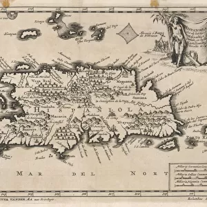
1859 Dufour Map Of Hispaniola Or Santo Domingo

![]()
Wall Art and Photo Gifts from Universal Images Group (UIG)
1859 Dufour Map Of Hispaniola Or Santo Domingo
1859, Dufour Map of Hispaniola or Santo Domingo, West Indies, Haiti, Dominican Republic
Universal Images Group (UIG) manages distribution for many leading specialist agencies worldwide
Media ID 38549284
© Artokoloro Quint Lox Limited
1859 Dominican Republic Haiti West Indies Antique Map Latitude Longitude Mappa Mundi Old Antique Plan Old Antique View Ols Antique Map Rare Old Maps Topo
FEATURES IN THESE COLLECTIONS
> Europe
> France
> Canton
> Landes
> Historic
> Space exploration
> Maps and Charts
> Early Maps
> Maps and Charts
> Related Images
> Maps and Charts
> World
> North America
> Dominican Republic
> Dominican Republic Heritage Sites
> Colonial City of Santo Domingo
> North America
> Dominican Republic
> Maps
> North America
> Dominican Republic
> Related Images
> North America
> Dominican Republic
> Santo Domingo
> North America
> Haiti
> Maps
> Universal Images Group (UIG)
> History
> Historical Maps
EDITORS COMMENTS
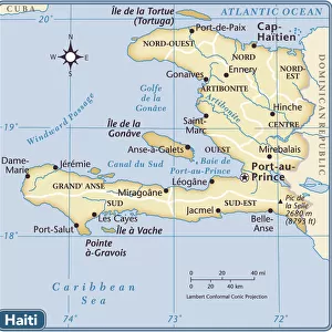
Step back in time to the mid-19th century with this stunning print of the 1859 Dufour Map of Hispaniola or Santo Domingo. Created by French cartographer Auguste Dufour, this vintage map showcases the island nation's intricate topography and geography in exquisite detail. The map depicts the shared border between Haiti and the Dominican Republic, highlighting the mountainous terrain, rivers, and coastal regions.
This beautiful illustration is a testament to Dufour's skill as a cartographer, with its precise lines and delicate shading bringing forth a sense of depth and dimensionality. The map also features latitude and longitude coordinates, providing insight into the region's geographic significance.
As you gaze upon this historic print, imagine yourself on a journey through time to an era when exploration was at its peak. This piece would make a unique addition to any collection or room decor, serving as a reminder of our rich cultural heritage and our enduring fascination with discovery.
The 1859 Dufour Map of Hispaniola or Santo Domingo is not only an impressive work of art but also a window into history that invites us to explore and learn about this fascinating region.
MADE IN THE USA
Safe Shipping with 30 Day Money Back Guarantee
FREE PERSONALISATION*
We are proud to offer a range of customisation features including Personalised Captions, Color Filters and Picture Zoom Tools
SECURE PAYMENTS
We happily accept a wide range of payment options so you can pay for the things you need in the way that is most convenient for you
* Options may vary by product and licensing agreement. Zoomed Pictures can be adjusted in the Cart.