Home > Europe > France > Canton > Landes
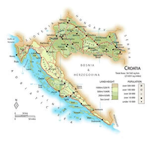
1852 S.D.U.K. Pocket Map Of The Balkans Croatia

![]()
Wall Art and Photo Gifts from Universal Images Group (UIG)
1852 S.D.U.K. Pocket Map Of The Balkans Croatia
1852, S.D.U.K. Pocket Map of the Balkans, Croatia, Dalmatia, Sclavonia
Universal Images Group (UIG) manages distribution for many leading specialist agencies worldwide
Media ID 38548968
© Artokoloro Quint Lox Limited
1852 Croatia Dalmatia Antique Map Latitude Longitude Mappa Mundi Old Antique Plan Old Antique View Ols Antique Map Rare Old Maps Topo
FEATURES IN THESE COLLECTIONS
> Europe
> Croatia
> Related Images
> Europe
> France
> Canton
> Landes
> Historic
> Space exploration
> Maps and Charts
> Early Maps
> Maps and Charts
> Related Images
> Maps and Charts
> World
> Universal Images Group (UIG)
> History
> Historical Maps
EDITORS COMMENTS
Step into the past with this exquisite 1852 S.D.U.K. Pocket Map of the Balkans, Croatia, Dalmatia, and Sclavonia. This vintage map is a stunning representation of the region's topography and geography during the mid-19th century. The intricate details showcase the borders, cities, rivers, and mountains that define this region.
The map's beauty lies not only in its historical significance but also in its artistic value. The delicate lines and subtle shading bring to life the rugged landscape of Croatia and surrounding areas. From the snow-capped peaks of Mount Velebit to the winding waters of the Adriatic Sea, every feature is meticulously rendered.
This rare old map is a treasure trove for history buffs, cartography enthusiasts, and anyone fascinated by geographical exploration. It's a window into a bygone era when maps were hand-drawn with precision and care. Take a journey through time with this beautiful piece of artistry as your guide.
Hang it on your wall or frame it as a keepsake - either way, this antique map will transport you to an era where discovery was around every corner.
MADE IN THE USA
Safe Shipping with 30 Day Money Back Guarantee
FREE PERSONALISATION*
We are proud to offer a range of customisation features including Personalised Captions, Color Filters and Picture Zoom Tools
SECURE PAYMENTS
We happily accept a wide range of payment options so you can pay for the things you need in the way that is most convenient for you
* Options may vary by product and licensing agreement. Zoomed Pictures can be adjusted in the Cart.