Home > Europe > France > Canton > Landes
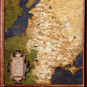
1799 Cary Map Of Prussia And Lithuania John Cary

![]()
Wall Art and Photo Gifts from Universal Images Group (UIG)
1799 Cary Map Of Prussia And Lithuania John Cary
1799, Cary Map of Prussia and Lithuania, John Cary, 1754 - 1835, was an English cartographer, John Cary, 1754 - 1835, English cartographer
Universal Images Group (UIG) manages distribution for many leading specialist agencies worldwide
Media ID 38550584
© Artokoloro Quint Lox Limited
1754 – 1835 1799 English Cartographer John Cary Was An English Cartographer Antique Map Latitude Longitude Mappa Mundi Old Antique Plan Old Antique View Ols Antique Map Rare Old Maps Topo
FEATURES IN THESE COLLECTIONS
> Europe
> France
> Canton
> Landes
> Europe
> Lithuania
> Related Images
> Historic
> Space exploration
> Maps and Charts
> Early Maps
> Maps and Charts
> Related Images
> Maps and Charts
> World
> Universal Images Group (UIG)
> History
> Historical Maps
EDITORS COMMENTS
Step back in time to the late 18th century with this stunning print of John Cary's 1799 map of Prussia and Lithuania. This beautifully rendered illustration is a testament to the cartographer's skill and attention to detail, showcasing the region's intricate geography and topography.
Published in London by John Cary, a renowned English cartographer, this map is a rare example of his work from the late 18th century. Cary was known for his meticulous approach to mapping, often incorporating new information and updates into his designs. This particular map features detailed illustrations of cities, towns, rivers, and mountains, providing a comprehensive view of the region.
The map also includes latitude and longitude lines, as well as other geographical markers that highlight its importance for navigation and exploration. The vintage aesthetic adds an air of nostalgia to this piece, making it not only a valuable resource for historians but also a beautiful addition to any room.
This print would be perfect for anyone who loves history, geography, or simply appreciates the beauty of old maps. It would make a unique conversation piece on your wall or office desk.
MADE IN THE USA
Safe Shipping with 30 Day Money Back Guarantee
FREE PERSONALISATION*
We are proud to offer a range of customisation features including Personalised Captions, Color Filters and Picture Zoom Tools
SECURE PAYMENTS
We happily accept a wide range of payment options so you can pay for the things you need in the way that is most convenient for you
* Options may vary by product and licensing agreement. Zoomed Pictures can be adjusted in the Cart.