Home > Europe > France > Canton > Landes
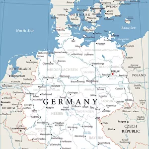
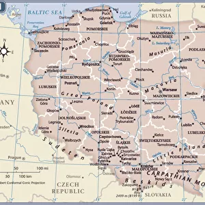
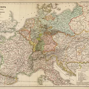
1775 Rizzi-Zannoni Map Of The German Empire And Poland

![]()
Wall Art and Photo Gifts from Universal Images Group (UIG)
1775 Rizzi-Zannoni Map Of The German Empire And Poland
1775, Rizzi-Zannoni Map of the German Empire and Poland
Universal Images Group (UIG) manages distribution for many leading specialist agencies worldwide
Media ID 38550340
© Artokoloro Quint Lox Limited
1775 Antique Map Latitude Longitude Mappa Mundi Old Antique Plan Old Antique View Ols Antique Map Rare Old Maps Topo
FEATURES IN THESE COLLECTIONS
> Europe
> France
> Canton
> Landes
> Europe
> Germany
> Related Images
> Europe
> Poland
> Related Images
> Historic
> Space exploration
> Maps and Charts
> Early Maps
> Maps and Charts
> Related Images
> Universal Images Group (UIG)
> History
> Historical Maps
EDITORS COMMENTS
Step back in time to the 18th century with this stunning print of the 1775 Rizzi-Zannoni Map of the German Empire and Poland. This exquisite illustration is a masterpiece of cartography, showcasing the geographic boundaries and topographic features of Central Europe during a pivotal moment in history.
Created by Italian cartographer Giovanni Francesco Rizzi-Zannoni, this map is a testament to his skill and attention to detail. The intricate design features lush forests, winding rivers, and majestic mountain ranges, all carefully rendered in precise lines and delicate shading. The map also includes numerous cities, towns, and villages, as well as roads, trade routes, and other notable landmarks.
This vintage map not only provides a fascinating glimpse into the past but also serves as a valuable resource for historians and geography enthusiasts alike. It's an incredible piece of art that would make a unique addition to any room or office decor. Whether you're interested in history, travel, or simply appreciate beautiful illustrations, this print is sure to captivate your imagination.
MADE IN THE USA
Safe Shipping with 30 Day Money Back Guarantee
FREE PERSONALISATION*
We are proud to offer a range of customisation features including Personalised Captions, Color Filters and Picture Zoom Tools
SECURE PAYMENTS
We happily accept a wide range of payment options so you can pay for the things you need in the way that is most convenient for you
* Options may vary by product and licensing agreement. Zoomed Pictures can be adjusted in the Cart.