Home > Europe > France > Canton > Landes
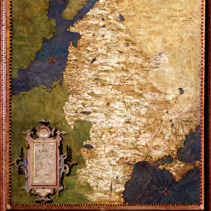
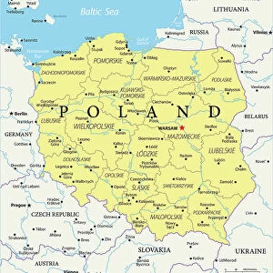
1771 Zannoni Map Of Poland And Lithuania Topography

![]()
Wall Art and Photo Gifts from Universal Images Group (UIG)
1771 Zannoni Map Of Poland And Lithuania Topography
1771, Zannoni Map of Poland and Lithuania
Universal Images Group (UIG) manages distribution for many leading specialist agencies worldwide
Media ID 38550314
© Artokoloro Quint Lox Limited
1771 Antique Map Latitude Longitude Mappa Mundi Old Antique Plan Old Antique View Ols Antique Map Rare Old Maps Topo
FEATURES IN THESE COLLECTIONS
> Europe
> France
> Canton
> Landes
> Europe
> Lithuania
> Related Images
> Europe
> Poland
> Related Images
> Historic
> Space exploration
> Maps and Charts
> Early Maps
> Maps and Charts
> Related Images
> Universal Images Group (UIG)
> History
> Historical Maps
EDITORS COMMENTS
Step back in time to the 18th century with this stunning print of the 1771 Zannoni Map of Poland and Lithuania Topography. This exquisite illustration is a testament to the cartographic skills of its creator, showcasing the geographical boundaries and topographical features of these two Eastern European countries.
The map's intricate details reveal a world before modern-day borders, highlighting the region's natural landmarks, rivers, forests, and cities. The meticulous hand-drawn design is a masterclass in geometric precision, with each line and curve carefully crafted to convey a sense of depth and dimensionality.
This vintage map not only provides a fascinating glimpse into the past but also serves as a reminder of humanity's enduring fascination with exploration and discovery. It invites us to imagine journeys through uncharted territories, tracing routes that have been traveled by countless travelers throughout history.
As an art piece or decorative element, this print adds a touch of elegance and sophistication to any room. Its aged patina imbues it with character, making it a unique conversation starter for anyone who appreciates history, geography, or simply beautiful illustrations. Whether you're an armchair traveler or an avid historian, this map is sure to transport you on an unforgettable journey through time.
MADE IN THE USA
Safe Shipping with 30 Day Money Back Guarantee
FREE PERSONALISATION*
We are proud to offer a range of customisation features including Personalised Captions, Color Filters and Picture Zoom Tools
SECURE PAYMENTS
We happily accept a wide range of payment options so you can pay for the things you need in the way that is most convenient for you
* Options may vary by product and licensing agreement. Zoomed Pictures can be adjusted in the Cart.