Home > Europe > France > Canton > Landes
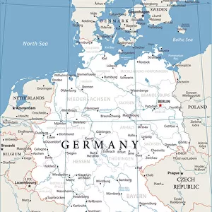
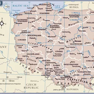
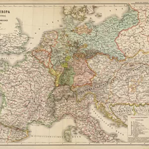
1771 Rizzi-Zannoni Map Of Germany And Poland

![]()
Wall Art and Photo Gifts from Universal Images Group (UIG)
1771 Rizzi-Zannoni Map Of Germany And Poland
1771, Rizzi-Zannoni Map of Germany and Poland
Universal Images Group (UIG) manages distribution for many leading specialist agencies worldwide
Media ID 38550306
© Artokoloro Quint Lox Limited
1771 Antique Map Latitude Longitude Mappa Mundi Old Antique Plan Old Antique View Ols Antique Map Rare Old Maps Topo
FEATURES IN THESE COLLECTIONS
> Europe
> France
> Canton
> Landes
> Europe
> Germany
> Related Images
> Europe
> Poland
> Related Images
> Historic
> Space exploration
> Maps and Charts
> Early Maps
> Maps and Charts
> Related Images
> Universal Images Group (UIG)
> History
> Historical Maps
EDITORS COMMENTS
Step back in time to the 18th century with this stunning print of the 1771 Rizzi-Zannoni Map of Germany and Poland. This beautifully illustrated map is a masterpiece of cartography, showcasing the geographic boundaries and topography of these two regions during a pivotal moment in European history.
The intricate details on this vintage map reveal the complex network of rivers, mountains, and cities that crisscrossed Germany and Poland during the late 18th century. The map's creator, Giovanni Battista Rizzi-Zannoni, was an Italian cartographer who worked for King Frederick II of Prussia. His meticulous attention to detail has resulted in a work that is both aesthetically pleasing and historically significant.
This print is not only a beautiful piece of art but also a valuable resource for historians, geographers, and anyone interested in exploring the past. It provides insight into how our understanding of geography has evolved over time and serves as a testament to human ingenuity in mapping our world.
Hang this magnificent print on your wall or use it as inspiration for your next project - either way, you'll be transported back to an era when exploration was at its peak.
MADE IN THE USA
Safe Shipping with 30 Day Money Back Guarantee
FREE PERSONALISATION*
We are proud to offer a range of customisation features including Personalised Captions, Color Filters and Picture Zoom Tools
SECURE PAYMENTS
We happily accept a wide range of payment options so you can pay for the things you need in the way that is most convenient for you
* Options may vary by product and licensing agreement. Zoomed Pictures can be adjusted in the Cart.