Home > Europe > France > Canton > Landes
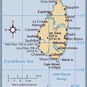
1758 Bellin Map Of St. Lucia St. Lucie In The West Indies

![]()
Wall Art and Photo Gifts from Universal Images Group (UIG)
1758 Bellin Map Of St. Lucia St. Lucie In The West Indies
1758, Bellin Map of St. Lucia, St. Lucie, in the West Indies
Universal Images Group (UIG) manages distribution for many leading specialist agencies worldwide
Media ID 38547991
© Artokoloro Quint Lox Limited
1758 Lucie Antique Map Latitude Longitude Lucia Mappa Mundi Old Antique Plan Old Antique View Ols Antique Map Rare Old Maps Topo
FEATURES IN THESE COLLECTIONS
> Europe
> France
> Canton
> Landes
> Historic
> Space exploration
> Maps and Charts
> Early Maps
> Maps and Charts
> World
> North America
> Saint Lucia
> Maps
> Universal Images Group (UIG)
> History
> Historical Maps
EDITORS COMMENTS
Step back in time to the 18th century with this exquisite print of the 1758 Bellin Map of St. Lucia, St. Lucie, in the West Indies. This stunning illustration is a testament to the artistry and cartographic skill of French cartographer Jacques-Nicolas Bellin, who was renowned for his meticulous attention to detail and beautiful hand-drawn designs.
This map provides a fascinating glimpse into the geography and topography of St. Lucia during a pivotal moment in its history. The island's lush green mountains, winding coastlines, and intricate network of rivers are depicted with remarkable accuracy, offering a captivating visual representation of this Caribbean gem.
The map also features an intriguing mix of scientific notation and artistic flair, showcasing Bellin's expertise as both a cartographer and illustrator. From latitude and longitude coordinates to decorative flourishes and ornate borders, every element has been carefully crafted to create a truly unique piece of historical art.
Whether you're an avid historian or simply appreciate vintage maps, this print is sure to delight with its beauty and historical significance. Hang it proudly on your wall as a reminder of the rich cultural heritage that shapes our understanding of the world today.
MADE IN THE USA
Safe Shipping with 30 Day Money Back Guarantee
FREE PERSONALISATION*
We are proud to offer a range of customisation features including Personalised Captions, Color Filters and Picture Zoom Tools
SECURE PAYMENTS
We happily accept a wide range of payment options so you can pay for the things you need in the way that is most convenient for you
* Options may vary by product and licensing agreement. Zoomed Pictures can be adjusted in the Cart.