Home > Europe > France > Canton > Landes
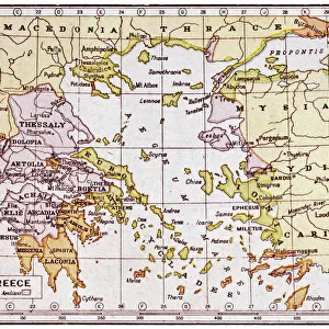
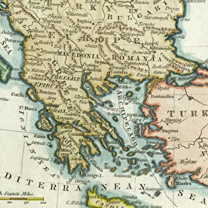
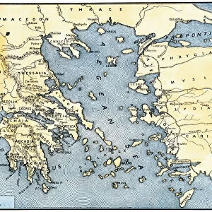
1752 Vaugondy Map Of Greece Macedonia And Albania

![]()
Wall Art and Photo Gifts from Universal Images Group (UIG)
1752 Vaugondy Map Of Greece Macedonia And Albania
1752, Vaugondy Map of Greece, Macedonia and Albania
Universal Images Group (UIG) manages distribution for many leading specialist agencies worldwide
Media ID 38547979
© Artokoloro Quint Lox Limited
1752 Antique Map Latitude Longitude Mappa Mundi Old Antique Plan Old Antique View Ols Antique Map Rare Old Maps Topo
FEATURES IN THESE COLLECTIONS
> Europe
> Albania
> Related Images
> Europe
> France
> Canton
> Landes
> Europe
> Greece
> Related Images
> Europe
> Macedonia
> Related Images
> Historic
> Ancient civilizations
> Ancient Greece
> Greek history
> Historic
> Space exploration
> Universal Images Group (UIG)
> History
> Historical Maps
EDITORS COMMENTS
Step back in time to the 18th century with this stunning print of the Vaugondy Map of Greece, Macedonia and Albania from 1752. This beautifully rendered illustration is a testament to the cartographic skills of French engraver Robert de Vaugondy, who meticulously mapped out the region's topography, geography, and landmarks.
The intricate details on this vintage map are a treasure trove for history buffs and geography enthusiasts alike. From the rugged mountains to the winding rivers, every feature is carefully depicted in exquisite detail. The map also includes illustrations of ancient ruins, cities, and towns, giving us a glimpse into the rich cultural heritage of these regions.
This rare and historic map is not only a beautiful piece of art but also a valuable resource for anyone interested in exploring the past. It's a window into a bygone era when exploration was still an exciting adventure and maps were handcrafted works of art.
Hang this print in your home or office as a conversation starter or use it as inspiration for your own travels. Whether you're an armchair traveler or an avid explorer, this Vaugondy Map will transport you back in time to an era when discovery was at its peak.
MADE IN THE USA
Safe Shipping with 30 Day Money Back Guarantee
FREE PERSONALISATION*
We are proud to offer a range of customisation features including Personalised Captions, Color Filters and Picture Zoom Tools
SECURE PAYMENTS
We happily accept a wide range of payment options so you can pay for the things you need in the way that is most convenient for you
* Options may vary by product and licensing agreement. Zoomed Pictures can be adjusted in the Cart.