Home > Europe > United Kingdom > England > London > Towns > Acton Green
Railway map, Acton, Kew, Turnham Green, London

![]()
Wall Art and Photo Gifts from Mary Evans Picture Library
Railway map, Acton, Kew, Turnham Green, London
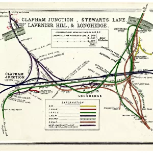
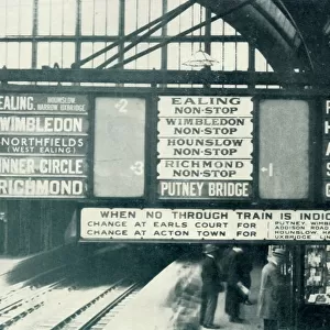
Railway map, Acton, Kew, South Acton & Turnham Green, London, with colour coding of the various railway companies. Date: 1913
Mary Evans Picture Library makes available wonderful images created for people to enjoy over the centuries
Media ID 23144180
© Mary Evans / Pharcide
Acton Coal Coding Companies Goods Inset Junction Junctions Lines Links Maps Stations Turnham
FEATURES IN THESE COLLECTIONS
> Arts
> Landscape paintings
> Waterfall and river artworks
> River artworks
> Europe
> United Kingdom
> England
> London
> Related Images
> Europe
> United Kingdom
> England
> London
> River Thames
> Europe
> United Kingdom
> England
> London
> Towns
> Acton Green
> Europe
> United Kingdom
> England
> London
> Towns
> Acton
> Europe
> United Kingdom
> England
> London
> Towns
> Kew
> Europe
> United Kingdom
> England
> London
> Towns
> South Acton
> Europe
> United Kingdom
> England
> London
> Towns
> West Acton
> Europe
> United Kingdom
> England
> London
> Towns
> West Green
> Europe
> United Kingdom
> England
> London
> Transport
> Railway
> Mary Evans Prints Online
> New Images August 2021
EDITORS COMMENTS
Step back in time with this railway map of Acton, Kew, South Acton, and Turnham Green in London, dating back to 1913. The intricate details of this vintage map showcase the extensive railway network that connected various parts of the city during the 1910s. The Thames River, a prominent feature of London, is depicted winding its way through the map, with several bridges and junctions marked along its course. The map is adorned with color-coded lines representing different railway companies, making it easier for commuters to navigate the complex web of railway links. The West London Railway Company's lines, for instance, are depicted in a deep red hue, while the Metropolitan Railway's lines are shown in a dark blue. The map also highlights various railway stations, including Acton Main Line, Kew Gardens, South Acton, and Turnham Green. This map offers a fascinating glimpse into London's transportation history, revealing the intricate railway network that connected various parts of the city during the early 20th century. The map also showcases the importance of coal and goods transportation, with several goods lines and coal yards marked on the map. The presence of junctions and the interconnecting lines demonstrate the efficiency of the railway system, which played a crucial role in the growth and development of London during this period.
MADE IN THE USA
Safe Shipping with 30 Day Money Back Guarantee
FREE PERSONALISATION*
We are proud to offer a range of customisation features including Personalised Captions, Color Filters and Picture Zoom Tools
SECURE PAYMENTS
We happily accept a wide range of payment options so you can pay for the things you need in the way that is most convenient for you
* Options may vary by product and licensing agreement. Zoomed Pictures can be adjusted in the Cart.