Fraud Blocker Skip to main content

Photographic Print > Maps and Charts > Finland

Finland Photographic Print Collection (#2)

Discover the breathtaking beauty of Finland with our collection of high-quality photographic prints. Featuring stunning landscapes, crystal-clear lakes, and enchanting forests, these prints capture the unique charm of this Nordic wonderland. Each print is meticulously crafted from premium photographic paper, ensuring vibrant colors and sharp details that bring the essence of Finland into your home or office. Immerse yourself in the magic of Finland's natural wonders and create a personal connection to this captivating country with our Finland collection of photographic prints.

Finland is a country located in northern Europe, bordered by Sweden, Norway

118 Photographic Prints

Background imageFinland Photographic Print Collection: Vaasa Province, 1856. Creator: Unknown

Vaasa Province, 1856. Creator: Unknown
Vaasa Province, 1856. This card is one of a souvenir set of 82 illustrated cards-one for each province of the Russian Empire as it existed in 1856

Background imageFinland Photographic Print Collection: General Map of Moscow Province: Showing Postal and Major Roads, Stations and... 1821

General Map of Moscow Province: Showing Postal and Major Roads, Stations and... 1821
General Map of Moscow Province: Showing Postal and Major Roads, Stations and the Distance in Versts between Them, 1821. This 1821 map of Moscow Province is from a larger work

Background imageFinland Photographic Print Collection: Uleaborg Province, 1856. Creator: Unknown

Uleaborg Province, 1856. Creator: Unknown
Uleaborg Province, 1856. This card is one of a souvenir set of 82 illustrated cards-one for each province of the Russian Empire as it existed in 1856

Background imageFinland Photographic Print Collection: Kuopio Province, 1856. Creator: Unknown

Kuopio Province, 1856. Creator: Unknown
Kuopio Province, 1856. This card is one of a souvenir set of 82 illustrated cards-one for each province of the Russian Empire as it existed in 1856

Background imageFinland Photographic Print Collection: General Map of Saint Petersburg Province: Showing Postal and Major Roads, Stations and the... 1820

General Map of Saint Petersburg Province: Showing Postal and Major Roads, Stations and the... 1820
General Map of Saint Petersburg Province: Showing Postal and Major Roads, Stations and the Distance in Versts between Them, 1820

Background imageFinland Photographic Print Collection: General Map of Livland Province: Showing Postal and Major Roads, Stations and the... 1820

General Map of Livland Province: Showing Postal and Major Roads, Stations and the... 1820
General Map of Livland Province: Showing Postal and Major Roads, Stations and the Distance in Versts between Them, 1820. This 1820 map of Livland Provinceis from a larger work

Background imageFinland Photographic Print Collection: General Map of Kherson Province: Showing Postal and Major Roads, Stations and... 1821

General Map of Kherson Province: Showing Postal and Major Roads, Stations and... 1821
General Map of Kherson Province: Showing Postal and Major Roads, Stations and the Distance in Versts between Them, 1821. This 1821 map of Kherson Provinceis from a larger work

Background imageFinland Photographic Print Collection: Saint Mikkel Province, 1856. Creator: Unknown

Saint Mikkel Province, 1856. Creator: Unknown
Saint Mikkel Province, 1856. This card is one of a souvenir set of 82 illustrated cards-one for each province of the Russian Empire as it existed in 1856

Background imageFinland Photographic Print Collection: General Map of Courland Province: Showing Postal and Major Roads, Stations and the... 1820

General Map of Courland Province: Showing Postal and Major Roads, Stations and the... 1820
General Map of Courland Province: Showing Postal and Major Roads, Stations and the Distance in Versts between Them, 1820. This 1820 map of Courland Province is from a larger work

Background imageFinland Photographic Print Collection: General Map of Kiev Province: Showing Postal and Major Roads, Stations and.. 1821

General Map of Kiev Province: Showing Postal and Major Roads, Stations and.. 1821
General Map of Kiev Province: Showing Postal and Major Roads, Stations and the Distance in Versts between Them, 1821. This 1821 map of Kiev Province is from a larger work

Background imageFinland Photographic Print Collection: General Map of Vilnius Province: Showing Postal and Major Roads, Stations and the... 1820

General Map of Vilnius Province: Showing Postal and Major Roads, Stations and the... 1820
General Map of Vilnius Province: Showing Postal and Major Roads, Stations and the Distance in Versts between Them, 1820. This 1820 map of Vilnius Provinceis from a larger work

Background imageFinland Photographic Print Collection: General Map of Grodno Province and the Belostok Region: Showing Postal and Major Roads... 1820

General Map of Grodno Province and the Belostok Region: Showing Postal and Major Roads... 1820
General Map of Grodno Province and the Belostok Region: Showing Postal and Major Roads, Stations and the Distance in Versts between Them, 1820

Background imageFinland Photographic Print Collection: General Map of Podolsk Province: Showing Postal and Major Roads, Stations and the... 1820

General Map of Podolsk Province: Showing Postal and Major Roads, Stations and the... 1820
General Map of Podolsk Province: Showing Postal and Major Roads, Stations and the Distance in Versts between Them, 1820. This 1820 map of Podolsk Provinceis from a larger work

Background imageFinland Photographic Print Collection: General Map of the Russian Empire and the Neighboring Polish.. 1827

General Map of the Russian Empire and the Neighboring Polish.. 1827. Creators: Vasilii Petrovich Piadyshev, Ieremin
General Map of the Russian Empire and the Neighboring Polish Empire and Grand Duchy of Finland: With the Distance in Versts on Postal Roads between Provincial Cities;

Background imageFinland Photographic Print Collection: General Map of Yaroslavl Province: Showing Postal and Major Roads, Stations and the... 1822

General Map of Yaroslavl Province: Showing Postal and Major Roads, Stations and the... 1822
General Map of Yaroslavl Province: Showing Postal and Major Roads, Stations and the Distance in Versts between Them, 1822

Background imageFinland Photographic Print Collection: General Map of Mogilev Province: Showing Postal and Major Roads, Stations and... 1821

General Map of Mogilev Province: Showing Postal and Major Roads, Stations and... 1821
General Map of Mogilev Province: Showing Postal and Major Roads, Stations and the Distance in Versts between Them, 1821. This 1821 map of Mogilev Provinceis from a larger work

Background imageFinland Photographic Print Collection: Tavastia Province, 1856. Creator: Unknown

Tavastia Province, 1856. Creator: Unknown
Tavastia Province, 1856. This card is one of a souvenir set of 82 illustrated cards-one for each province of the Russian Empire as it existed in 1856

Background imageFinland Photographic Print Collection: General Map of Voronezh Province: Showing Postal and Major Roads, Stations and the... 1822

General Map of Voronezh Province: Showing Postal and Major Roads, Stations and the... 1822
General Map of Voronezh Province: Showing Postal and Major Roads, Stations and the Distance in Versts between Them, 1822. This 1822 map of Voronezh Provinceis from a larger work

Background imageFinland Photographic Print Collection: General Map of Tambov Province: Showing Postal and Major Roads, Stations and the... 1822

General Map of Tambov Province: Showing Postal and Major Roads, Stations and the... 1822
General Map of Tambov Province: Showing Postal and Major Roads, Stations and the Distance in Versts between Them, 1822. This 1822 map of Tambov Provinceis from a larger work

Background imageFinland Photographic Print Collection: General Map of the Polish Empire: Showing Postal and Major Roads, Stations and the... 1820

General Map of the Polish Empire: Showing Postal and Major Roads, Stations and the... 1820
General Map of the Polish Empire: Showing Postal and Major Roads, Stations and the Distance in Miles Between Them, 1820. This 1820 map of the Polish Empire, then part of the Russian Empire

Background imageFinland Photographic Print Collection: General Map of Kostroma Province: Showing Postal and Major Roads, Stations and... 1822

General Map of Kostroma Province: Showing Postal and Major Roads, Stations and... 1822
General Map of Kostroma Province: Showing Postal and Major Roads, Stations and the Distance in Versts between Them, 1822. This 1822 map of Kostroma Provinceis from a larger work

Background imageFinland Photographic Print Collection: General Map of Orel Province: Showing Postal and Major Roads, Stations and... 1822

General Map of Orel Province: Showing Postal and Major Roads, Stations and... 1822
General Map of Orel Province: Showing Postal and Major Roads, Stations and the Distance in Versts between Them, 1822. This 1822 map of Orel Province is from a larger work

Background imageFinland Photographic Print Collection: General Map of Taurida Province: Showing Postal and Major Roads, Stations and.. 1822

General Map of Taurida Province: Showing Postal and Major Roads, Stations and.. 1822
General Map of Taurida Province: Showing Postal and Major Roads, Stations and the Distance in Versts between Them, 1822. This 1822 map ofTaurida Provinceis from a larger work

Background imageFinland Photographic Print Collection: General Map of Ryazan Province: Showing Postal and Major Roads, Stations and... 1822

General Map of Ryazan Province: Showing Postal and Major Roads, Stations and... 1822
General Map of Ryazan Province: Showing Postal and Major Roads, Stations and the Distance in Versts between Them, 1822. This 1822 map of Ryazan Provinceis from a larger work

Background imageFinland Photographic Print Collection: General Map of Tula Province: Showing Postal and Major Roads, Stations and... 1822

General Map of Tula Province: Showing Postal and Major Roads, Stations and... 1822
General Map of Tula Province: Showing Postal and Major Roads, Stations and the Distance in Versts between Them, 1822. This 1822 map of Tula Provinceis from a larger work

Background imageFinland Photographic Print Collection: General Map of Estland Province: Showing Postal and Major Roads, Stations and... 1820

General Map of Estland Province: Showing Postal and Major Roads, Stations and... 1820
General Map of Estland Province: Showing Postal and Major Roads, Stations and the Distance in Versts between Them, 1820. This 1820 map of Estland Province is from a larger work

Background imageFinland Photographic Print Collection: General Map of Volhynia Province: Showing Postal and Major Roads, Stations... 1820

General Map of Volhynia Province: Showing Postal and Major Roads, Stations... 1820
General Map of Volhynia Province: Showing Postal and Major Roads, Stations and the Distance in Versts between Them, 1820. This 1820 map of Volhynia Provinceis from a larger work

Background imageFinland Photographic Print Collection: Stockport SK3 9 Map

Stockport SK3 9 Map
Postcode Sector Map of Stockport SK3 9

Background imageFinland Photographic Print Collection: Antique map of Denmark, Norway, Sweden and Finland

Antique map of Denmark, Norway, Sweden and Finland
Wonderful hand coloured antique map, circa 1780 - 1800

Background imageFinland Photographic Print Collection: Helsinki

Helsinki
StudioSix

Background imageFinland Photographic Print Collection: HELSINKI

HELSINKI
StudioSix

Background imageFinland Photographic Print Collection: 13849201

13849201

Background imageFinland Photographic Print Collection: 13824478

13824478

Background imageFinland Photographic Print Collection: Map of the countries around the Arctic Circle with the three voyages of the Dutch in 1598

Map of the countries around the Arctic Circle with the three voyages of the Dutch in 1598, 1878 (litho)
7415818 Map of the countries around the Arctic Circle with the three voyages of the Dutch in 1598, 1878 (litho) by Doetechum, Baptista van (active 1583-1611) (after) ; 43.5 x 56.5 cm; Rijksmuseum

Background imageFinland Photographic Print Collection: Detail of A Map of the Sea (Carta marina) by Olaus Magnus (1490-1557), 1572 (engraving)

Detail of A Map of the Sea (Carta marina) by Olaus Magnus (1490-1557), 1572 (engraving)
7394857 Detail of A Map of the Sea (Carta marina) by Olaus Magnus (1490-1557), 1572 (engraving) by Lafrery, Antoine (1512-77); Private Collection; (add.info)

Background imageFinland Photographic Print Collection: Detail of A Map of the Sea (Carta marina) by Olaus Magnus (1490-1557), 1572 (engraving)

Detail of A Map of the Sea (Carta marina) by Olaus Magnus (1490-1557), 1572 (engraving)
7394859 Detail of A Map of the Sea (Carta marina) by Olaus Magnus (1490-1557), 1572 (engraving) by Lafrery, Antoine (1512-77); Private Collection; (add.info)

Background imageFinland Photographic Print Collection: Detail of A Map of the Sea (Carta marina) by Olaus Magnus (1490-1557), 1572 (engraving)

Detail of A Map of the Sea (Carta marina) by Olaus Magnus (1490-1557), 1572 (engraving)
7394858 Detail of A Map of the Sea (Carta marina) by Olaus Magnus (1490-1557), 1572 (engraving) by Lafrery, Antoine (1512-77); Private Collection; (add.info)

Background imageFinland Photographic Print Collection: Map of the Sea (Carta marina) by Olaus Magnus (1490-1557), 1572 (engraving)

Map of the Sea (Carta marina) by Olaus Magnus (1490-1557), 1572 (engraving)
7393830 Map of the Sea (Carta marina) by Olaus Magnus (1490-1557), 1572 (engraving) by Lafrery, Antoine (1512-77); Private Collection; (add.info)

Background imageFinland Photographic Print Collection: Dutch Trade Map of the Baltic Sea

Dutch Trade Map of the Baltic Sea
Dutch Trade map of the Baltic Sea (hand-coloured engraving) During the last decades of the 16th century and throughout the 17th century Dutch merchants

Background imageFinland Photographic Print Collection: The cigar chewers, 1919 (photo)

The cigar chewers, 1919 (photo)
7207384 The cigar chewers, 1919 (photo) by Barsokevitsch, Victor (1863 - 1933); Private Collection; Prismatic Pictures

Background imageFinland Photographic Print Collection: Portrait of Mans Schjerfbeck, 1928-29 (oil on canvas)

Portrait of Mans Schjerfbeck, 1928-29 (oil on canvas)
7076457 Portrait of Mans Schjerfbeck, 1928-29 (oil on canvas) by Schjerfbeck, Helene (1862-1946); 45.4x36.8 cm; Private Collection; Finnish, out of copyright

Background imageFinland Photographic Print Collection: An interrupted wedding feast (litho)

An interrupted wedding feast (litho)
7171076 An interrupted wedding feast (litho) by American School, (20th century); Private Collection; (add.info.: An interrupted wedding feast)

Background imageFinland Photographic Print Collection: Portrait de Gustav Mahler (1860-1911) - Peinture de Akseli (Axel-Gallen)

Portrait de Gustav Mahler (1860-1911) - Peinture de Akseli (Axel-Gallen, Axel Gallen) Gallen-Kallela (Gallen Kallela)
FIA5383378 Portrait de Gustav Mahler (1860-1911) - Peinture de Akseli (Axel-Gallen, Axel Gallen) Gallen-Kallela (Gallen Kallela) (1865-1931), huile sur toile, 1907, art finlandais, 20e siecle

Background imageFinland Photographic Print Collection: A fishers service in Finland (litho)

A fishers service in Finland (litho)
7171082 A fishers service in Finland (litho) by American School, (20th century); Private Collection; (add.info.: A fishers service in Finland)

Background imageFinland Photographic Print Collection: Bombardement de Sweaborg (engraving)

Bombardement de Sweaborg (engraving)
7179606 Bombardement de Sweaborg (engraving) by French School, (19th century); Private Collection; (add.info.: Bombardement de Sweaborg)

Background imageFinland Photographic Print Collection: Members of the League of Nations (colour litho)

Members of the League of Nations (colour litho)
7163177 Members of the League of Nations (colour litho) by English School, (20th century); Private Collection; (add.info.: Members of the League of Nations)

Background imageFinland Photographic Print Collection: Ms. 1288 fol. 1 The Polar Aurora, from a Collection of Dutch Marine Maps

Ms. 1288 fol. 1 The Polar Aurora, from a Collection of Dutch Marine Maps
BIF271726 Ms. 1288 fol. 1 The Polar Aurora, from a Collection of Dutch Marine Maps (engraving) by Gerritsz, Hessel (1581-1632); Bibliotheque de l Institut de France, Paris

Background imageFinland Photographic Print Collection: Map of the northern kingdoms (Denmark, Sweden, Norway and Finland) (etching, 1730)

Map of the northern kingdoms (Denmark, Sweden, Norway and Finland) (etching, 1730)
LRI4706355 Map of the northern kingdoms (Denmark, Sweden, Norway and Finland) (etching, 1730) by Delisle, Guillaume (1675-1726); Private Collection; (add.info.: Map of the northern kingdoms)


All Professionally Made to Order for Quick Shipping


-

Finland Photographic Print Collection

Finland is a country located in northern Europe, bordered by Sweden, Norway, and Russia and has a population of approximately 5.5 million people and covers an area of 338,000 square kilometers. The capital city is Helsinki, which is also the largest city in the country. A highly developed economy that relies heavily on exports of technology products such as mobile phones and electronics. The country's education system is considered one of the best in the world with free education for all citizens from primary to tertiary level. Finland boasts beautiful natural landscapes including forests, lakes and islands making it popular among tourists seeking outdoor activities such as hiking or skiing during winter months.
+

Our beautiful Wall Art and Photo Gifts include Framed Prints, Photo Prints, Poster Prints, Canvas Prints, Jigsaw Puzzles, Metal Prints and so much more

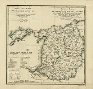
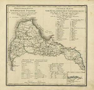
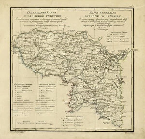
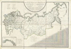
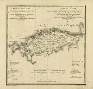
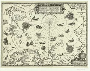
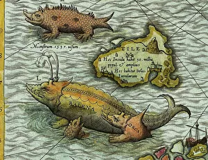
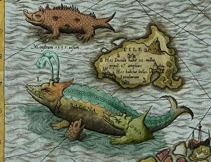
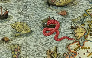
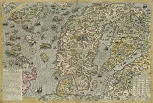
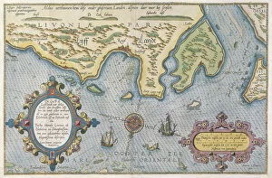
The Finland collection from Media Storehouse is a stunning compilation of wall art and framed prints that showcase the beauty, history, and geography of Finland. Our collection features an array of maps and charts that depict various aspects of the country, including its topography, cities, regions, lakes, rivers, forests, and more. Each print in our collection is carefully crafted with high-quality materials to ensure longevity and durability. The prints are available in different sizes to suit individual preferences and can be customized with frames or mounts for added elegance. Whether you're looking to decorate your home or office space or seeking unique gifts for friends or family members who love Finland's culture and heritage, our collection has something for everyone. With its rich colors, intricate details, and captivating imagery of Finland's landscapes and landmarks - from Helsinki to Lapland - our collection is sure to impress any art enthusiast or nature lover.
+

What are Finland (Maps and Charts) art prints?

Finland art prints are a collection of high-quality, visually stunning prints that showcase the geography and topography of Finland. These prints feature detailed maps and charts that highlight the country's diverse landscapes, from its rugged coastline to its vast forests and lakes. They are perfect for anyone who loves exploring new places or has an interest in geography. The Finland art prints come in a variety of sizes, making them suitable for any space. Whether you're looking to add some color to your living room or want to create a focal point in your office, these prints will make a great addition to any decor. Each print is produced using state-of-the-art printing technology, ensuring that every detail is captured with precision. The result is a beautiful, high-quality print that will last for years to come. So if you're looking for a unique way to showcase your love for Finland or simply want to add some visual interest to your home or office, consider investing in one of these stunning art prints today.
+

What Finland (Maps and Charts) art prints can I buy from Media Storehouse?

We offer a wide range of Finland Maps and Charts art prints that you can purchase. These prints showcase the beauty and diversity of Finland's landscapes, cities, and regions. You can choose from an array of options such as vintage maps, topographic maps, satellite imagery, cityscapes, and more. Some popular choices include Helsinki cityscape at sunset or in winter snowfall; Lapland region with its stunning aurora borealis displays; Turku archipelago with its picturesque islands dotted around the Baltic Sea; Oulanka National Park with its rugged terrain and waterfalls; Finnish Lakeland area with its thousands of lakes interconnected by rivers. These art prints are perfect for adding a touch of Nordic charm to your home decor or office space. They also make great gifts for anyone who loves travel or has a special connection to Finland. With our extensive collection, you're sure to find the perfect print that captures your imagination.
+

How do I buy Finland (Maps and Charts) art prints?

To buy Finland art prints from Media Storehouse, you can browse our extensive collection of artwork online. Simply search for "Finland Maps and Charts" in the search bar on our website to find a variety of options. Once you have found a print that you like, select the size and framing options that suit your preferences. You can choose from a range of materials including canvas, paper or metal prints. You will also be able to select different finishes such as matte or glossy depending on your preference. We offer secure payment methods so you can purchase your chosen print with confidence. We also offer international shipping so no matter where you are located, you can enjoy beautiful artwork inspired by Finland's maps and charts. Whether it's for personal use or as a gift for someone special, buying Finland art prints from Media Storehouse is easy and convenient.
+

How much do Finland (Maps and Charts) art prints cost?

We offer a wide range of Finland Maps and Charts art prints for purchase. Our prices vary depending on the size and type of print you choose. We have options ranging from small posters to large canvas prints, so there is something for every budget. Our Finland Maps and Charts art prints are high-quality reproductions that capture the beauty and detail of these historic maps. They make great additions to any home or office decor, adding a touch of sophistication and elegance. Whether you're looking for a vintage map of Helsinki or an antique chart of the Finnish coastline, we have something to suit your needs. Our selection includes both black-and-white and color prints, so you can choose the style that best fits your taste. Our Finland Maps and Charts art prints are competitively priced while still maintaining their quality standards.
+

How will my Finland (Maps and Charts) art prints be delivered to me?

We take great care in ensuring that your Finland art prints are delivered to you safely and securely. Once you have placed your order with us, our team of experts will carefully package your print using high-quality materials to protect it during transit. We offer a range of delivery options to suit your needs, including standard shipping and express delivery for those who need their prints sooner. Our delivery partners are reliable and efficient, ensuring that your print arrives at its destination on time and in perfect condition. Whether you're ordering a single print or multiple pieces for a larger project, we pride ourselves on providing excellent customer service throughout the entire process. If you have any questions about how your Finland art prints will be delivered to you, please don't hesitate to get in touch with our friendly team who will be happy to help.