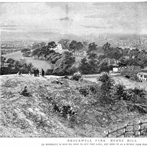
Home > Europe > United Kingdom > England > London > Sights > Brockwell Park
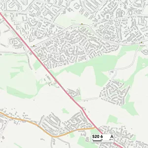
Chesterfield S42 7 Map

![]()
Wall Art and Photo Gifts from Map Marketing
Chesterfield S42 7 Map
Postcode Sector Map of Chesterfield S42 7
Media ID 19979006
Alton Close Athol Close Badger Close Barley Lane Baslow Road Berwick Avenue Bowland Drive Bradshaw Lane Brook Close Chesterfield Claypit Lane Common Lane Cornfield Close Crescent Road Fairfield Court Fairfield Drive Farndale Avenue Green Lane Grove Lane Hall Close Harewood Road Harvest Way Hay Lane Heather Way High Lane Hill Lane Hollins Linacre Road Main Road Matlock Road Meadow Rise Netherfield Lane New Road Norfolk Close North Lane Oaks Lane Old School Close Pinfold Close Piper Lane Plantation Close Priory Close Riverside Crescent Royston Close Sackville Close School Lane Short Close Snipe Close St Johns Close The Crescent The Grange The Meadows Thorne Close Top Lane Well Lane Birley
FEATURES IN THESE COLLECTIONS
> Animals
> Birds
> Charadriiformes
> Sandpipers
> Common Snipe
> Animals
> Mammals
> Pedetidae
> Spring Hare
> Arts
> Artists
> B
> John Brooks
> Arts
> Artists
> F
> John Field
> Arts
> Artists
> H
> John Hillers
> Arts
> Artists
> H
> John Hills
> Arts
> Artists
> L
> John Lodge
> Europe
> United Kingdom
> England
> London
> Sights
> Brockwell Park
> Europe
> United Kingdom
> England
> Norfolk
> Bagthorpe
> Map Marketing
> Postcode Sector Maps
> S - Sheffield
MADE IN THE USA
Safe Shipping with 30 Day Money Back Guarantee
FREE PERSONALISATION*
We are proud to offer a range of customisation features including Personalised Captions, Color Filters and Picture Zoom Tools
SECURE PAYMENTS
We happily accept a wide range of payment options so you can pay for the things you need in the way that is most convenient for you
* Options may vary by product and licensing agreement. Zoomed Pictures can be adjusted in the Cart.