Home > Animals > Mammals > Muridae > Steppe Mouse
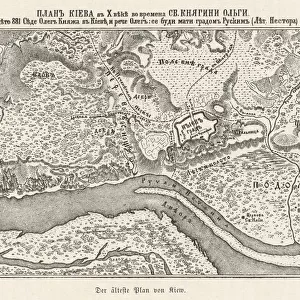
Siege of Sebastopol - map, 1854. Creator: Unknown

![]()
Wall Art and Photo Gifts from Heritage Images
Siege of Sebastopol - map, 1854. Creator: Unknown
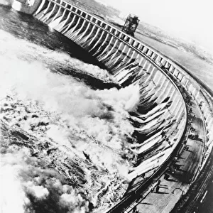
Siege of Sebastopol - map, 1854. Crimean War. The Black Sea, town and harbour of Sebastopol, Rivers Belbec, Katchka and Alma, Balaklava, roads to Eupatoria and Simferopol, Barren Steppes, Cape Constantine. The siege of[Russian-held] Sebastopol [by the Allied armies] bids fair to rank as the most remarkable operation in the annals of modern warfare. It is true we are no longer at a time when sieges were carried on with guns of small calibre, requiring a near approach to the walls to be effective against them. All the science of first parallel and second parallel is growing old, and armies, when they have advanced within 900 yards of stone walls, find that they are as close as they require; and, that with heavy 95 cwt. pieces, they can batter and breach to such purpose, that the work of a fortnight in the olden time is completed in twenty-four hours'. From "Illustrated London News", 1854
Heritage Images features heritage image collections
Media ID 36233275
© The Print Collector/Heritage Images
Alma Balaclava Crimean Peninsula Ukraine Balaklava Ukraine Besieged Black Sea Coastline Crimea Ukraine Crimean War Disputed Territory Port River Alma Sebastopol Krym Ukraine Sevastopol Ukraine Siege Siege Of Sebastopol Siege Of Sevastopol Territorial Territory
FEATURES IN THESE COLLECTIONS
> Animals
> Mammals
> Cats (Domestic)
> Russian White
> Animals
> Mammals
> Muridae
> Steppe Mouse
> Europe
> Ukraine
> Related Images
EDITORS COMMENTS
This map print depicts the strategic location of the Siege of Sebastopol during the Crimean War in 1854. The Black Sea town and harbor of Sebastopol, now part of Ukraine, is shown with its surrounding geographical features, including the rivers Belbec, Katchka, and Alma, the towns of Balaklava and Eupatoria, and the roads leading to Simferopol. The map highlights the disputed territory between Russia and the Allied forces, with the siege bidding fair to rank as one of the most remarkable operations in modern warfare. The advancements in military technology during the 19th century had rendered traditional siege tactics obsolete, and armies could now effectively breach stone walls with heavy 95 cwt. pieces, completing the work of a fortnight in a single day. This map, published in the Illustrated London News, offers a unique perspective into the geographical and strategic considerations of the Crimean War, providing valuable insights into the military operations and territorial disputes of the time.
MADE IN THE USA
Safe Shipping with 30 Day Money Back Guarantee
FREE PERSONALISATION*
We are proud to offer a range of customisation features including Personalised Captions, Color Filters and Picture Zoom Tools
SECURE PAYMENTS
We happily accept a wide range of payment options so you can pay for the things you need in the way that is most convenient for you
* Options may vary by product and licensing agreement. Zoomed Pictures can be adjusted in the Cart.