
Subduction Zone Collection
A subduction zone is a fascinating phenomenon that occurs at the boundaries of Earth's tectonic plates


All Professionally Made to Order for Quick Shipping
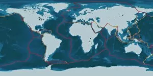
A subduction zone is a fascinating phenomenon that occurs at the boundaries of Earth's tectonic plates. These plate boundaries come in various types, each with its own unique characteristics and consequences. Imagine a diagram showcasing Africa and the Atlantic Ocean, where clouds gracefully hover above. This visual representation highlights the intricate relationship between these two landmasses and their surrounding waters. Now picture earthquake tension maps of Turkey, illustrating the immense pressure building up beneath its surface. The fault lines crisscrossing this region serve as reminders of the constant geological activity occurring deep within our planet. Moving towards Caribbean plate tectonics, an artwork captures the dynamic nature of this area's plate boundary. It showcases how these plates interact, collide, or slide past one another – shaping not only the landscape but also influencing seismic events in this part of the world. Another artwork depicts an earthquake and tsunami scenario to emphasize how they can trigger devastating natural disasters. The collision between tectonic plates can lead to sudden shifts in Earth's crust, resulting in powerful quakes followed by massive oceanic waves capable of altering coastlines forever. Delving deeper into Earth's internal structure through yet another artwork reveals layers upon layers hidden beneath our feet. From solid inner core to liquid outer core, from mantle to crust – understanding these components helps us comprehend why subduction zones exist and how they impact our planet's geology. Shifting focus to sea floor topography brings us to different regions across the globe. In "The Americas, " we observe intricate details captured by C016 / 3726 imagery – unveiling underwater mountain ranges and deep trenches that trace along continental margins. In contrast, "Atlantic Ocean" sea floor topography (C016 / 3725) presents a distinct layout characterized by mid-ocean ridges stretching for thousands of miles while separating vast expanses on either side. Venturing into Indian Ocean territory unveils mesmerizing visuals combining chlorophyll and bathymetry (C016 / 3723).