Fraud Blocker Skip to main content

Computer Graphic Collection (#8)

Unleash your creativity with the mesmerizing world of computer graphics

Background imageComputer Graphic Collection: MA Hampden East Longmeadow Vector Road Map

MA Hampden East Longmeadow Vector Road Map. All source data is in the public domain. U.S. Census Bureau Census Tiger. Used Layers: areawater, linearwater, roads, rails, cousub, pointlm, uac10

Background imageComputer Graphic Collection: MA Hampden Agawam Town Vector Road Map

MA Hampden Agawam Town Vector Road Map. All source data is in the public domain. U.S. Census Bureau Census Tiger. Used Layers: areawater, linearwater, roads, rails, cousub, pointlm, uac10
Background imageComputer Graphic Collection: MA Hampden Chester Vector Road Map

MA Hampden Chester Vector Road Map. All source data is in the public domain. U.S. Census Bureau Census Tiger. Used Layers: areawater, linearwater, roads, rails, cousub, pointlm, uac10

Background imageComputer Graphic Collection: MA Hampden Town Vector Road Map

MA Hampden Town Vector Road Map. All source data is in the public domain. U.S. Census Bureau Census Tiger. Used Layers: areawater, linearwater, roads, rails, cousub, pointlm, uac10

Background imageComputer Graphic Collection: MA Hampden Russell Vector Road Map

MA Hampden Russell Vector Road Map. All source data is in the public domain. U.S. Census Bureau Census Tiger. Used Layers: areawater, linearwater, roads, rails, cousub, pointlm, uac10

Background imageComputer Graphic Collection: MA Hampden Montgomery Vector Road Map

MA Hampden Montgomery Vector Road Map. All source data is in the public domain. U.S. Census Bureau Census Tiger. Used Layers: areawater, linearwater, roads, rails, cousub, pointlm, uac10

Background imageComputer Graphic Collection: MA Hampden Monson Vector Road Map

MA Hampden Monson Vector Road Map. All source data is in the public domain. U.S. Census Bureau Census Tiger. Used Layers: areawater, linearwater, roads, rails, cousub, pointlm, uac10

Background imageComputer Graphic Collection: MA Hampden Holland Vector Road Map

MA Hampden Holland Vector Road Map. All source data is in the public domain. U.S. Census Bureau Census Tiger. Used Layers: areawater, linearwater, roads, rails, cousub, pointlm, uac10

Background imageComputer Graphic Collection: MA Hampden Longmeadow Vector Road Map

MA Hampden Longmeadow Vector Road Map. All source data is in the public domain. U.S. Census Bureau Census Tiger. Used Layers: areawater, linearwater, roads, rails, cousub, pointlm, uac10

Background imageComputer Graphic Collection: MA Hampden Holyoke Vector Road Map

MA Hampden Holyoke Vector Road Map. All source data is in the public domain. U.S. Census Bureau Census Tiger. Used Layers: areawater, linearwater, roads, rails, cousub, pointlm, uac10

Background imageComputer Graphic Collection: MA Hampden Ludlow Vector Road Map

MA Hampden Ludlow Vector Road Map. All source data is in the public domain. U.S. Census Bureau Census Tiger. Used Layers: areawater, linearwater, roads, rails, cousub, pointlm, uac10

Background imageComputer Graphic Collection: MA Hampden Palmer Town Vector Road Map

MA Hampden Palmer Town Vector Road Map. All source data is in the public domain. U.S. Census Bureau Census Tiger. Used Layers: areawater, linearwater, roads, rails, cousub, pointlm, uac10

Background imageComputer Graphic Collection: MA Hampden Tolland Vector Road Map

MA Hampden Tolland Vector Road Map. All source data is in the public domain. U.S. Census Bureau Census Tiger. Used Layers: areawater, linearwater, roads, rails, cousub, pointlm, uac10

Background imageComputer Graphic Collection: MA Hampden Westfield Vector Road Map

MA Hampden Westfield Vector Road Map. All source data is in the public domain. U.S. Census Bureau Census Tiger. Used Layers: areawater, linearwater, roads, rails, cousub, pointlm, uac10

Background imageComputer Graphic Collection: MA Hampden Wales Vector Road Map

MA Hampden Wales Vector Road Map. All source data is in the public domain. U.S. Census Bureau Census Tiger. Used Layers: areawater, linearwater, roads, rails, cousub, pointlm, uac10

Background imageComputer Graphic Collection: MA Hampden Springfield Vector Road Map

MA Hampden Springfield Vector Road Map. All source data is in the public domain. U.S. Census Bureau Census Tiger. Used Layers: areawater, linearwater, roads, rails, cousub, pointlm, uac10

Background imageComputer Graphic Collection: MA Hampden Southwick Vector Road Map

MA Hampden Southwick Vector Road Map. All source data is in the public domain. U.S. Census Bureau Census Tiger. Used Layers: areawater, linearwater, roads, rails, cousub, pointlm, uac10

Background imageComputer Graphic Collection: MA Hampden West Springfield Town Vector Road Map

MA Hampden West Springfield Town Vector Road Map. All source data is in the public domain. U.S. Census Bureau Census Tiger. Used Layers: areawater, linearwater, roads, rails, cousub, pointlm, uac10

Background imageComputer Graphic Collection: MA Hampden Wilbraham Vector Road Map

MA Hampden Wilbraham Vector Road Map. All source data is in the public domain. U.S. Census Bureau Census Tiger. Used Layers: areawater, linearwater, roads, rails, cousub, pointlm, uac10

Background imageComputer Graphic Collection: MA Franklin Ashfield Vector Road Map

MA Franklin Ashfield Vector Road Map. All source data is in the public domain. U.S. Census Bureau Census Tiger. Used Layers: areawater, linearwater, roads, rails, cousub, pointlm, uac10

Background imageComputer Graphic Collection: MA Franklin Colrain Vector Road Map

MA Franklin Colrain Vector Road Map. All source data is in the public domain. U.S. Census Bureau Census Tiger. Used Layers: areawater, linearwater, roads, rails, cousub, pointlm, uac10

Background imageComputer Graphic Collection: MA Franklin Buckland Vector Road Map

MA Franklin Buckland Vector Road Map. All source data is in the public domain. U.S. Census Bureau Census Tiger. Used Layers: areawater, linearwater, roads, rails, cousub, pointlm, uac10

Background imageComputer Graphic Collection: MA Franklin Bernardston Vector Road Map

MA Franklin Bernardston Vector Road Map. All source data is in the public domain. U.S. Census Bureau Census Tiger. Used Layers: areawater, linearwater, roads, rails, cousub, pointlm, uac10

Background imageComputer Graphic Collection: MA Franklin Gill Vector Road Map

MA Franklin Gill Vector Road Map. All source data is in the public domain. U.S. Census Bureau Census Tiger. Used Layers: areawater, linearwater, roads, rails, cousub, pointlm, uac10

Background imageComputer Graphic Collection: MA Franklin Deerfield Vector Road Map

MA Franklin Deerfield Vector Road Map. All source data is in the public domain. U.S. Census Bureau Census Tiger. Used Layers: areawater, linearwater, roads, rails, cousub, pointlm, uac10

Background imageComputer Graphic Collection: MA Franklin Charlemont Vector Road Map

MA Franklin Charlemont Vector Road Map. All source data is in the public domain. U.S. Census Bureau Census Tiger. Used Layers: areawater, linearwater, roads, rails, cousub, pointlm, uac10

Background imageComputer Graphic Collection: MA Franklin Erving Vector Road Map

MA Franklin Erving Vector Road Map. All source data is in the public domain. U.S. Census Bureau Census Tiger. Used Layers: areawater, linearwater, roads, rails, cousub, pointlm, uac10

Background imageComputer Graphic Collection: MA Franklin Conway Vector Road Map

MA Franklin Conway Vector Road Map. All source data is in the public domain. U.S. Census Bureau Census Tiger. Used Layers: areawater, linearwater, roads, rails, cousub, pointlm, uac10

Background imageComputer Graphic Collection: MA Franklin Heath Vector Road Map

MA Franklin Heath Vector Road Map. All source data is in the public domain. U.S. Census Bureau Census Tiger. Used Layers: areawater, linearwater, roads, rails, cousub, pointlm, uac10

Background imageComputer Graphic Collection: MA Franklin Montague Vector Road Map

MA Franklin Montague Vector Road Map. All source data is in the public domain. U.S. Census Bureau Census Tiger. Used Layers: areawater, linearwater, roads, rails, cousub, pointlm, uac10

Background imageComputer Graphic Collection: MA Franklin Greenfield Town Vector Road Map

MA Franklin Greenfield Town Vector Road Map. All source data is in the public domain. U.S. Census Bureau Census Tiger. Used Layers: areawater, linearwater, roads, rails, cousub, pointlm, uac10

Background imageComputer Graphic Collection: MA Franklin New Salem Vector Road Map

MA Franklin New Salem Vector Road Map. All source data is in the public domain. U.S. Census Bureau Census Tiger. Used Layers: areawater, linearwater, roads, rails, cousub, pointlm, uac10

Background imageComputer Graphic Collection: MA Franklin Hawley Vector Road Map

MA Franklin Hawley Vector Road Map. All source data is in the public domain. U.S. Census Bureau Census Tiger. Used Layers: areawater, linearwater, roads, rails, cousub, pointlm, uac10

Background imageComputer Graphic Collection: MA Franklin Monroe Vector Road Map

MA Franklin Monroe Vector Road Map. All source data is in the public domain. U.S. Census Bureau Census Tiger. Used Layers: areawater, linearwater, roads, rails, cousub, pointlm, uac10

Background imageComputer Graphic Collection: MA Franklin Leyden Vector Road Map

MA Franklin Leyden Vector Road Map. All source data is in the public domain. U.S. Census Bureau Census Tiger. Used Layers: areawater, linearwater, roads, rails, cousub, pointlm, uac10

Background imageComputer Graphic Collection: MA Franklin Leverett Vector Road Map

MA Franklin Leverett Vector Road Map. All source data is in the public domain. U.S. Census Bureau Census Tiger. Used Layers: areawater, linearwater, roads, rails, cousub, pointlm, uac10

Background imageComputer Graphic Collection: MA Worcester Milford Vector Road Map

MA Worcester Milford Vector Road Map. All source data is in the public domain. U.S. Census Bureau Census Tiger. Used Layers: areawater, linearwater, roads, rails, cousub, pointlm, uac10

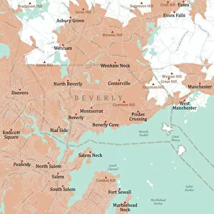
Background imageComputer Graphic Collection: MA Essex Beverly Vector Road Map

MA Essex Beverly Vector Road Map. All source data is in the public domain. U.S. Census Bureau Census Tiger. Used Layers: areawater, linearwater, roads, rails, cousub, pointlm, uac10

Background imageComputer Graphic Collection: MA Essex Methuen Town Vector Road Map

MA Essex Methuen Town Vector Road Map. All source data is in the public domain. U.S. Census Bureau Census Tiger. Used Layers: areawater, linearwater, roads, rails, cousub, pointlm, uac10

Background imageComputer Graphic Collection: MA Essex Merrimac Vector Road Map

MA Essex Merrimac Vector Road Map. All source data is in the public domain. U.S. Census Bureau Census Tiger. Used Layers: areawater, linearwater, roads, rails, cousub, pointlm, uac10

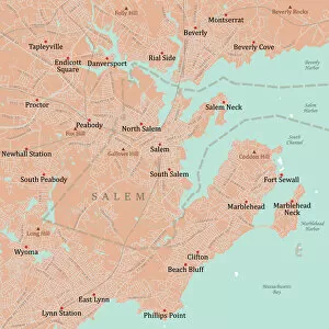
Background imageComputer Graphic Collection: MA Essex Salem Vector Road Map

MA Essex Salem Vector Road Map. All source data is in the public domain. U.S. Census Bureau Census Tiger. Used Layers: areawater, linearwater, roads, rails, cousub, pointlm, uac10

Background imageComputer Graphic Collection: MA Essex Newburyport Vector Road Map

MA Essex Newburyport Vector Road Map. All source data is in the public domain. U.S. Census Bureau Census Tiger. Used Layers: areawater, linearwater, roads, rails, cousub, pointlm, uac10

Background imageComputer Graphic Collection: MA Essex North Andover Vector Road Map

MA Essex North Andover Vector Road Map. All source data is in the public domain. U.S. Census Bureau Census Tiger. Used Layers: areawater, linearwater, roads, rails, cousub, pointlm, uac10

Background imageComputer Graphic Collection: MA Essex Newbury Vector Road Map

MA Essex Newbury Vector Road Map. All source data is in the public domain. U.S. Census Bureau Census Tiger. Used Layers: areawater, linearwater, roads, rails, cousub, pointlm, uac10

Background imageComputer Graphic Collection: MA Essex Amesbury Town Vector Road Map

MA Essex Amesbury Town Vector Road Map. All source data is in the public domain. U.S. Census Bureau Census Tiger. Used Layers: areawater, linearwater, roads, rails, cousub, pointlm, uac10

Background imageComputer Graphic Collection: MA Franklin Shutesbury Vector Road Map

MA Franklin Shutesbury Vector Road Map. All source data is in the public domain. U.S. Census Bureau Census Tiger. Used Layers: areawater, linearwater, roads, rails, cousub, pointlm, uac10

Background imageComputer Graphic Collection: MA Franklin Rowe Vector Road Map

MA Franklin Rowe Vector Road Map. All source data is in the public domain. U.S. Census Bureau Census Tiger. Used Layers: areawater, linearwater, roads, rails, cousub, pointlm, uac10

Background imageComputer Graphic Collection: MA Franklin Sunderland Vector Road Map

MA Franklin Sunderland Vector Road Map. All source data is in the public domain. U.S. Census Bureau Census Tiger. Used Layers: areawater, linearwater, roads, rails, cousub, pointlm, uac10


All Professionally Made to Order for Quick Shipping

Unleash your creativity with the mesmerizing world of computer graphics. 🎨✨ Let the 'Be yourself' gold foil message guide you as you explore the limitless possibilities of digital art. Dive into the captivating Art of Schrodingers Cat experiment, where reality and imagination merge seamlessly on your screen. Travel back in time with an old Caucasus map, or embark on a new adventure with Costa Rica Vector Map - let them inspire your next masterpiece. Marvel at the intricate Computer artwork of ATLAS detector at CERN, showcasing the beauty of science through pixels and colors. Navigate through Ipswich Suffolk UK City Street Map and trust that every step is part of your unique journey. Delve into Fusion research with tokamak device, unraveling secrets to sustainable energy while admiring its elegant design. Lose yourself in the enchanting Fractal artwork, where math meets aesthetics in a symphony of patterns and shapes resembling delicate butterflies fluttering gracefully. And who could resist The pineapple (Ananas comosus) - a tropical delight brought to life by computer graphics? Finally, get captivated by 2C-B psychedelic drug's molecular model; witness how technology can visualize complex structures beyond our perception. With computer graphics as your canvas, let your imagination soar.