Home > Arts > Contemporary art > Digital artwork > Street art
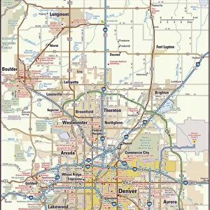
MA Middlesex North Reading Vector Road Map

![]()
Wall Art and Photo Gifts from Fine Art Storehouse
MA Middlesex North Reading Vector Road Map
MA Middlesex North Reading Vector Road Map. All source data is in the public domain. U.S. Census Bureau Census Tiger. Used Layers: areawater, linearwater, roads, rails, cousub, pointlm, uac10
Unleash your creativity and transform your space into a visual masterpiece!
Frank Ramspott
Media ID 20691131
© Frank Ramspott, all rights reserved
City Map Computer Graphic County Digital Composite District Geographical Border Massachusetts Middlesex Road Map Text Vector Digitally Generated Image West Village
FEATURES IN THESE COLLECTIONS
> Animals
> Mammals
> Cats (Wild)
> Tiger
> Animals
> Mammals
> Muridae
> Water Mouse
> Arts
> Contemporary art
> Digital artwork
> Street art
> Arts
> Landscape paintings
> Waterfall and river artworks
> River artworks
> Arts
> Portraits
> Pop art gallery
> Street art portraits
> Arts
> Street art graffiti
> Digital art
> Digital paintings
> Europe
> United Kingdom
> England
> Middlesex
> Related Images
> Fine Art Storehouse
> Map
> Reference Maps
> Maps and Charts
> Related Images
> Popular Themes
> Lake District
EDITORS COMMENTS
This vibrant and detailed print showcases the MA Middlesex North Reading Vector Road Map, a stunning piece of cartography created by Frank Ramspott. The map encompasses various layers of information, including areawater, linearwater, roads, rails, cousub, pointlm, and uac10. All source data used in this digital composite image is sourced from the public domain U. S. Census Bureau Census Tiger. The design of this map is visually striking with its bold colors and precise vector lines. It beautifully captures the physical geography of Middlesex County in Massachusetts while highlighting key cities such as North Reading, West Village, South Middleton, and Lynnfield. While there are no people depicted in this digitally generated image, it serves as an invaluable tool for anyone seeking to navigate or explore the region. The inclusion of text labels ensures that viewers can easily identify rivers, lakes, streets and other geographical features within Middlesex County. Frank Ramspott's expertise in cartography shines through in this artwork. Through his meticulous attention to detail and skillful use of computer graphics technology he has created a visually appealing representation of this area's road network. This print is perfect for those who appreciate both artistry and functionality; it seamlessly combines elements of design with practicality to create a unique piece that will enhance any space.
MADE IN THE USA
Safe Shipping with 30 Day Money Back Guarantee
FREE PERSONALISATION*
We are proud to offer a range of customisation features including Personalised Captions, Color Filters and Picture Zoom Tools
SECURE PAYMENTS
We happily accept a wide range of payment options so you can pay for the things you need in the way that is most convenient for you
* Options may vary by product and licensing agreement. Zoomed Pictures can be adjusted in the Cart.