Home > Animals > Mammals > Cats (Wild) > Tiger
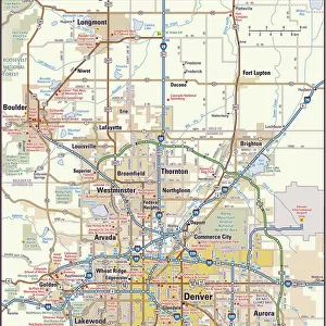
CT Fairfield Redding Vector Road Map

![]()
Wall Art and Photo Gifts from Fine Art Storehouse
CT Fairfield Redding Vector Road Map
CT Fairfield Redding Vector Road Map. All source data is in the public domain. U.S. Census Bureau Census Tiger. Used Layers: areawater, linearwater, roads, rails, cousub, pointlm, uac10
Unleash your creativity and transform your space into a visual masterpiece!
Frank Ramspott
Media ID 20688227
© Frank Ramspott, all rights reserved
Boston City Map Computer Graphic Connecticut County Digital Composite District Fairfield Geographical Border Road Map Text Vector Digitally Generated Image Fox Hill Hopewell Redding
FEATURES IN THESE COLLECTIONS
> Animals
> Mammals
> Cats (Wild)
> Tiger
> Animals
> Mammals
> Dogs (Wild)
> Red Fox
> Animals
> Mammals
> Muridae
> Water Mouse
> Arts
> Contemporary art
> Digital artwork
> Pop art
> Arts
> Contemporary art
> Digital artwork
> Street art
> Arts
> Contemporary art
> Pop art
> Digital art
> Arts
> Landscape paintings
> Waterfall and river artworks
> River artworks
> Arts
> Still life artwork
> Pop art
> Digital art
> Arts
> Modern art pieces
> Pop art
> Street art
> Fine Art Storehouse
> Map
> Reference Maps
EDITORS COMMENTS
This print showcases the intricate and detailed CT Fairfield Redding Vector Road Map. Designed by Frank Ramspott, this digitally generated image is a testament to his exceptional cartography skills. The map encompasses various elements of physical geography, including rivers, lakes, and towns such as Fairfield, Redding, Sanfordtown, Lonetown, Hopewell, Fox Hill, Sunset Hill, Branchville, Boston and Pop Mountain. Using layers sourced from the U. S. Census Bureau Census Tiger database (areawater, linearwater roads), as well as cousub (county subdivision), pointlm (point landmark), uac10 (urban area cluster 2010) data sets; this vector road map provides an accurate representation of the region's geographical borders and transportation infrastructure. The vibrant colors used in this computer graphic composition make it visually appealing while maintaining its authenticity. This stunning print is perfect for those who appreciate fine art that combines design with functionality
MADE IN THE USA
Safe Shipping with 30 Day Money Back Guarantee
FREE PERSONALISATION*
We are proud to offer a range of customisation features including Personalised Captions, Color Filters and Picture Zoom Tools
SECURE PAYMENTS
We happily accept a wide range of payment options so you can pay for the things you need in the way that is most convenient for you
* Options may vary by product and licensing agreement. Zoomed Pictures can be adjusted in the Cart.