Home > North America > Cuba > Cuba Heritage Sites > Old Havana and its Fortification System
Geography Atlas: representation of the Caribbean Sea, Caribbean Sea (Cuba, Jamaica, Caiman Islands), Bahamas Islands, South United States (Florida), North South America (Venezuela) and Mexico
, Bahamas Islands, South United States (Florida), North South America (Venezuela) and Mexico")
![]()
Wall Art and Photo Gifts from Fine Art Finder
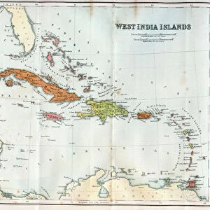
Geography Atlas: representation of the Caribbean Sea, Caribbean Sea (Cuba, Jamaica, Caiman Islands), Bahamas Islands, South United States (Florida), North South America (Venezuela) and Mexico
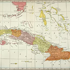
VEN5029603 Geography Atlas: representation of the Caribbean Sea, Caribbean Sea (Cuba, Jamaica, Caiman Islands), Bahamas Islands, South United States (Florida), North South America (Venezuela) and Mexico. Map taken from an Atlas of American Odds by Pieter Vander AA based on the description of Franciscus de Garay in 1519, 1728. Biblioteca Jose Marti, Havana, Cuba.; (add.info.: Geography Atlas: representation of the Caribbean Sea, Caribbean Sea (Cuba, Jamaica, Caiman Islands), Bahamas Islands, South United States (Florida), North South America (Venezuela) and Mexico. Map taken from an Atlas of American Odds by Pieter Vander AA based on the description of Franciscus de Garay in 1519, 1728. Biblioteca Jose Marti, Havana, Cuba.); © Marage Photos
Media ID 38094284
© © Marage Photos / Bridgeman Images
Amerique Centrale Amerique Continent Amerique Du Nord Amerique Du Sud Brasil Brazil Brazil Brasilian Brazil Brazilian Brazilian Brazilians Bresil Bresilien Bresilienne Caraïbes Caribbean Caribbean Island Carte Geographique Central America Cuba Cuba Cubain Cubaine Cubains Cubaines Cuban Etats Unis Geographie Jamaica Jamaican Latin America Latinamerica Southamerica Stockravenna Venezuela Venezuelan 18eme Siecle America Continent Geographical Map Latine America
FEATURES IN THESE COLLECTIONS
> Fine Art Finder
> Costume & Fashion
> Maps and Charts
> Early Maps
> North America
> The Bahamas
> Maps
> North America
> The Bahamas
> Related Images
> North America
> Cuba
> Cuba Heritage Sites
> Old Havana and its Fortification System
> North America
> Cuba
> Havana
> North America
> Cuba
> Maps
> North America
> Cuba
> Related Images
> North America
> Jamaica
> Maps
> North America
> Jamaica
> Related Images
EDITORS COMMENTS
This stunning print of a Geography Atlas showcases the intricate details of the Caribbean Sea, including Cuba, Jamaica, the Cayman Islands, the Bahamas Islands, South United States (Florida), North South America (Venezuela), and Mexico. The map is taken from an Atlas of American Odds by Pieter Vander AA based on the description of Franciscus de Garay in 1519. This particular piece is housed in the Biblioteca Jose Marti in Havana, Cuba.
The vibrant colors and precise cartography capture the essence of these diverse regions in the 18th century. From the lush landscapes of Brazil to the bustling cities of North America, this map provides a window into a time when exploration and discovery shaped our understanding of geography.
As you gaze upon this image, you can almost feel yourself transported back in time to an era when sailors navigated uncharted waters and adventurers sought new lands. The intricate details and historical significance make this Geography Atlas print a true work of art that will inspire curiosity and wonder for generations to come.
Whether you have a passion for history or simply appreciate beautiful craftsmanship, this print is sure to captivate your imagination and spark your sense of adventure. Explore the Americas through this depiction of their geographical wonders.
MADE IN THE USA
Safe Shipping with 30 Day Money Back Guarantee
FREE PERSONALISATION*
We are proud to offer a range of customisation features including Personalised Captions, Color Filters and Picture Zoom Tools
SECURE PAYMENTS
We happily accept a wide range of payment options so you can pay for the things you need in the way that is most convenient for you
* Options may vary by product and licensing agreement. Zoomed Pictures can be adjusted in the Cart.