Home > Europe > United Kingdom > England > London > Museums > National Maritime Museum
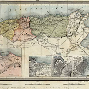
A new and exact map of the island of Antigua in America, according to a survey made in the years 1746-1748, c.1749 (coloured engraving)
")
![]()
Wall Art and Photo Gifts from Fine Art Finder
A new and exact map of the island of Antigua in America, according to a survey made in the years 1746-1748, c.1749 (coloured engraving)
7340453 A new and exact map of the island of Antigua in America, according to a survey made in the years 1746-1748, c.1749 (coloured engraving) by Baker, Robert (18th century); 10.9x62 cm; National Maritime Museum, London, UK; (add.info.: Creator: Robert Baker
The title continues: Describing the limits and boundaries of the several parishes, with the churches, also the divisions with their respective boundaries, high roads, jury paths, the situation of every gentleman's plantation, mills, works and houses, with the harbours, bays, creeks, islands, rocks, shoals & soundings that surround the whole. Caribbean and Gulf of Mexico. Robert Baker was Surveyor General of Antigua and father of Samuel Baker who mapped St Christopher.); © National Maritime Museum, Greenwich, London
Media ID 38410198
© © National Maritime Museum, Greenwich, London / Bridgeman Images
Central America Etching Islands Isles Geographer
FEATURES IN THESE COLLECTIONS
> Animals
> Mammals
> Muridae
> House Mouse
> Arts
> Artists
> B
> Robert Baker
> Arts
> Artists
> B
> Samuel Baker
> Europe
> United Kingdom
> England
> London
> Boroughs
> Greenwich
> Europe
> United Kingdom
> England
> London
> Museums
> Greenwich Heritage Centre
> Europe
> United Kingdom
> England
> London
> Museums
> National Maritime Museum
> Europe
> United Kingdom
> England
> London
> Towns
> Greenwich
> Europe
> United Kingdom
> Heritage Sites
> Maritime Greenwich
> Europe
> United Kingdom
> Maps
> Fine Art Finder
> Artists
> Robert Baker
> Fine Art Finder
> Artists
> Unknown Artist
EDITORS COMMENTS
This beautifully detailed colored engraving from the 18th century depicts "A new and exact map of the island of Antigua in America," created by Robert Baker. The map, based on a survey conducted between 1746-1748, provides a comprehensive view of the island's geography, including parish boundaries, churches, roads, plantations, mills, harbors, bays, and more.
Robert Baker, the Surveyor General of Antigua and father of Samuel Baker who mapped St. Christopher (now known as Saint Kitts), meticulously captured every detail to create this intricate cartographic masterpiece. The map not only serves as a valuable geographical resource but also offers insight into the historical landscape of Antigua during that period.
As you study this historic print closely, you can almost imagine yourself exploring the island centuries ago. The vibrant colors bring to life the lush landscapes and coastal features that have shaped Antigua's history and culture over time.
Whether you're a cartography enthusiast or simply appreciate fine art from bygone eras, this map is sure to spark your curiosity about one of America's most enchanting islands. Display it proudly in your home or office as a conversation piece that will transport you back in time to colonial-era Antigua.
MADE IN THE USA
Safe Shipping with 30 Day Money Back Guarantee
FREE PERSONALISATION*
We are proud to offer a range of customisation features including Personalised Captions, Color Filters and Picture Zoom Tools
SECURE PAYMENTS
We happily accept a wide range of payment options so you can pay for the things you need in the way that is most convenient for you
* Options may vary by product and licensing agreement. Zoomed Pictures can be adjusted in the Cart.