Home > Europe > United Kingdom > England > London > Museums > National Maritime Museum
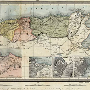
Map of Asia and America, 1777 (coloured engraving)
")
![]()
Wall Art and Photo Gifts from Fine Art Finder
Map of Asia and America, 1777 (coloured engraving)
7295385 Map of Asia and America, 1777 (coloured engraving) by Krevelt, Abram van (1732-84); 26x390 cm; National Maritime Museum, London, UK; (add.info.: Creator: Jacques Nicolas Bellin; A van Krevelt
Single sheet. Hand col. engr. Medium: In card mount. Scale: [ca. 1:25 000 000]. Cartographic Note: Graduated, meridian of Paris, Mercator projection. Scale in French marine leagues. Contents Note: Notes on discoveries and geographical theories, eg The English search in this area for a passage to enter the South Sea but there is reason to believe that there is no such thing'. Inscribed Carte reduite des parties septentrionales du globe, situees entre l'Asie et l'Amerique pour servir a L'Histoire Generale des Voyages. Par M. Bellin Ingr. de la Marine.'); © National Maritime Museum, Greenwich, London
Media ID 38431634
© © National Maritime Museum, Greenwich, London / Bridgeman Images
FEATURES IN THESE COLLECTIONS
> Europe
> France
> Paris
> Maps
> Europe
> United Kingdom
> England
> London
> Boroughs
> Greenwich
> Europe
> United Kingdom
> England
> London
> Museums
> Greenwich Heritage Centre
> Europe
> United Kingdom
> England
> London
> Museums
> National Maritime Museum
> Europe
> United Kingdom
> England
> London
> Towns
> Greenwich
> Europe
> United Kingdom
> Heritage Sites
> Maritime Greenwich
> Europe
> United Kingdom
> Maps
> Fine Art Finder
> Artists
> Unknown Artist
> Maps and Charts
> Early Maps
EDITORS COMMENTS
This stunning coloured engraving from 1777 depicts a Map of Asia and America, created by Jacques Nicolas Bellin and engraved by Abram van Krevelt. Measuring 26x390 cm, this intricate map is housed at the National Maritime Museum in London, UK.
The map showcases the northern parts of the globe between Asia and America, with detailed notes on discoveries and geographical theories of the time. The cartographic details include a graduated scale, meridian of Paris, Mercator projection, and scale in French marine leagues.
Inscribed with "Carte reduite des parties septentrionales du globe," this historical piece serves as a valuable resource for understanding the world as it was perceived in the 18th century. It provides insights into early exploration efforts to find passages between continents and sheds light on the evolving knowledge of geography during that era.
With its vibrant colours and precise engravings, this map captures the essence of cartography in the 18th century. It stands as a testament to human curiosity and determination to explore unknown territories. A true masterpiece that continues to inspire awe and wonder centuries after its creation.
MADE IN THE USA
Safe Shipping with 30 Day Money Back Guarantee
FREE PERSONALISATION*
We are proud to offer a range of customisation features including Personalised Captions, Color Filters and Picture Zoom Tools
SECURE PAYMENTS
We happily accept a wide range of payment options so you can pay for the things you need in the way that is most convenient for you
* Options may vary by product and licensing agreement. Zoomed Pictures can be adjusted in the Cart.