Home > North America > Canada > Maps
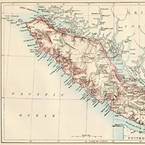
Geographic map of Vancouver Island (British Columbia, Canada) and its coastline, 1887. Lithograph of the 19th century
 and its coastline, 1887. Lithograph of the 19th century")
![]()
Wall Art and Photo Gifts from Fine Art Finder
Geographic map of Vancouver Island (British Columbia, Canada) and its coastline, 1887. Lithograph of the 19th century
NWI4867453 Geographic map of Vancouver Island (British Columbia, Canada) and its coastline, 1887. Lithograph of the 19th century; (add.info.: Geographic map of Vancouver Island (British Columbia, Canada) and its coastline, 1887. Lithograph of the 19th century); Photo © North Wind Pictures
Media ID 38426948
© © North Wind Pictures / Bridgeman Images
FEATURES IN THESE COLLECTIONS
> Fine Art Finder
> Artists
> Unknown Artist
> Maps and Charts
> Early Maps
> Maps and Charts
> Related Images
> North America
> Canada
> Maps
> North America
> Canada
> Related Images
> North America
> Canada
> Vancouver
> North America
> United States of America
> Maps
> Popular Themes
> North Island
EDITORS COMMENTS
This stunning lithograph from the 19th century showcases a detailed geographic map of Vancouver Island and its coastline in British Columbia, Canada. The intricate details and vibrant colors bring this historical map to life, offering a glimpse into the past of this beautiful region.
The map provides a fascinating look at the layout of Vancouver Island in 1887, capturing the geography and topography of the area with precision. From lush forests to rugged coastlines, every feature is meticulously depicted on this print.
As you study this piece, you can imagine what life was like in British Columbia during this time period. The map serves as a window into history, allowing us to explore how the land was used and inhabited over a century ago.
Whether you have a personal connection to Vancouver Island or simply appreciate cartography and history, this lithograph is sure to captivate your imagination. It's a reminder of the rich heritage and natural beauty that define this region of Canada.
Displaying this print in your home or office will not only add an artistic touch but also spark conversations about the past and present of Vancouver Island. Let it serve as a conversation starter and source of inspiration for all who view it.
MADE IN THE USA
Safe Shipping with 30 Day Money Back Guarantee
FREE PERSONALISATION*
We are proud to offer a range of customisation features including Personalised Captions, Color Filters and Picture Zoom Tools
SECURE PAYMENTS
We happily accept a wide range of payment options so you can pay for the things you need in the way that is most convenient for you
* Options may vary by product and licensing agreement. Zoomed Pictures can be adjusted in the Cart.