Home > Europe > United Kingdom > England > London > Museums > National Maritime Museum
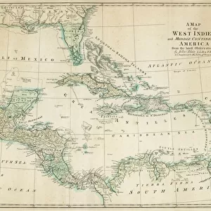
A complete map of the West Indies containing the coasts of Florida, Louisiana, New Spain and Terra Firma with all the islands, 1794 (print)
")
![]()
Wall Art and Photo Gifts from Fine Art Finder
A complete map of the West Indies containing the coasts of Florida, Louisiana, New Spain and Terra Firma with all the islands, 1794 (print)
7339476 A complete map of the West Indies containing the coasts of Florida, Louisiana, New Spain and Terra Firma with all the islands, 1794 (print) by Dunn, Samuel (18th century); 33x46 cm; National Maritime Museum, London, UK; (add.info.: Creator: Samuel Dunn; Laurie & Whittle
Single sheet. Scale: circa 1:9 500 000 (bar). Cartographic Note: Longitude from Ferro. 41 in top and bottom right corners.); © National Maritime Museum, Greenwich, London
Media ID 38516554
© © National Maritime Museum, Greenwich, London / Bridgeman Images
British West Indies Coast Line Florida Islands Isles Louisiana West Indies
FEATURES IN THESE COLLECTIONS
> Europe
> Spain
> Related Images
> Europe
> United Kingdom
> England
> London
> Boroughs
> Greenwich
> Europe
> United Kingdom
> England
> London
> Museums
> British Museum
> Europe
> United Kingdom
> England
> London
> Museums
> Greenwich Heritage Centre
> Europe
> United Kingdom
> England
> London
> Museums
> National Maritime Museum
> Europe
> United Kingdom
> England
> London
> Sights
> British Museum
> Europe
> United Kingdom
> England
> London
> Towns
> Greenwich
> Europe
> United Kingdom
> Heritage Sites
> Maritime Greenwich
> Fine Art Finder
> Artists
> Simon de Passe
EDITORS COMMENTS
This stunning 18th-century print showcases a complete map of the West Indies, including the coasts of Florida, Louisiana, New Spain, and Terra Firma with all the surrounding islands. Created by Samuel Dunn and published by Laurie & Whittle, this intricate cartographic masterpiece is a true testament to the artistry and precision of mapmaking during this era.
Measuring 33x46 cm, this single sheet map features a scale of approximately 1:9,500,000 (bar) with longitude measured from Ferro. The corners are marked with '41', adding to the historical significance of this piece. The vibrant colors used in this print bring to life the coastlines, islands, and seas depicted on the map.
As you study each detail carefully, you can't help but be transported back in time to an era when exploration and discovery were at their peak. The British West Indies come alive on paper as you trace your finger along the coastlines and imagine what life was like for those who navigated these waters centuries ago.
Whether you're a history buff or simply appreciate fine craftsmanship, this print is sure to captivate your imagination and spark curiosity about the rich maritime history of the West Indies. Display it proudly in your home or office as a conversation starter that will transport you to another time and place every time you gaze upon it.
MADE IN THE USA
Safe Shipping with 30 Day Money Back Guarantee
FREE PERSONALISATION*
We are proud to offer a range of customisation features including Personalised Captions, Color Filters and Picture Zoom Tools
SECURE PAYMENTS
We happily accept a wide range of payment options so you can pay for the things you need in the way that is most convenient for you
* Options may vary by product and licensing agreement. Zoomed Pictures can be adjusted in the Cart.