Home > Arts > Artists > A > Benedict Arnold
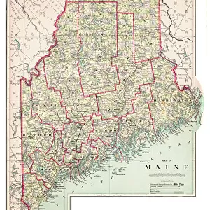
Map of the inland territories of Maine, used by Benedict Arnold (1741-1801), at the head of the continental army, for the invasion of Quebec (Canada), 1775. Coloured water, 19th century
, at the head of the continental army, for the invasion of Quebec (Canada), 1775. Coloured water, 19th century")
![]()
Wall Art and Photo Gifts from Fine Art Finder
Map of the inland territories of Maine, used by Benedict Arnold (1741-1801), at the head of the continental army, for the invasion of Quebec (Canada), 1775. Coloured water, 19th century
NWI4840594 Map of the inland territories of Maine, used by Benedict Arnold (1741-1801), at the head of the continental army, for the invasion of Quebec (Canada), 1775. Coloured water, 19th century.; (add.info.: Map of the inland territories of Maine, used by Benedict Arnold (1741-1801), at the head of the continental army, for the invasion of Quebec (Canada), 1775. Coloured water, 19th century.); Photo © North Wind Pictures
Media ID 38483828
© © North Wind Pictures / Bridgeman Images
FEATURES IN THESE COLLECTIONS
> Arts
> Artists
> A
> Benedict Arnold
> Europe
> France
> Canton
> Maine
> Fine Art Finder
> Artists
> Pasquier (workshop of) Grenier
> Maps and Charts
> Early Maps
> Maps and Charts
> Related Images
> North America
> Canada
> Maps
> North America
> Canada
> Related Images
> North America
> Related Images
> North America
> United States of America
> Maine
> Related Images
> North America
> United States of America
> Maps
EDITORS COMMENTS
This stunning print captures a piece of history in vivid detail - the Map of the inland territories of Maine used by Benedict Arnold at the head of the continental army for the invasion of Quebec in 1775. The coloured water map, dating back to the 19th century, provides a glimpse into Arnold's strategic planning and determination during this pivotal moment in American history.
As we gaze upon this intricate map, we can almost feel the weight of responsibility that Arnold must have carried as he led his troops into unknown territory. The detailed markings and annotations on the map speak to his meticulous preparation and unwavering commitment to achieving victory against all odds.
The vibrant colors bring life to this historical artifact, reminding us of the courage and sacrifice displayed by those who fought for freedom and independence. It serves as a powerful reminder of our nation's roots and the bravery that shaped our collective identity.
Through this photo print, we are transported back in time to witness a crucial chapter in America's journey towards self-determination. It is a testament to the resilience and spirit of those who dared to dream big and challenge convention for a better future.
MADE IN THE USA
Safe Shipping with 30 Day Money Back Guarantee
FREE PERSONALISATION*
We are proud to offer a range of customisation features including Personalised Captions, Color Filters and Picture Zoom Tools
SECURE PAYMENTS
We happily accept a wide range of payment options so you can pay for the things you need in the way that is most convenient for you
* Options may vary by product and licensing agreement. Zoomed Pictures can be adjusted in the Cart.