Home > North America > Cuba > Maps
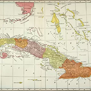
Geography map: representation of the southern island of Cuba and the island of Hispaniola and the small Caribbean, made by the Dutch cartographer Gerard van Keulen (1678-1726) 1709-1713. Biblioteca Angelica, Rome
 1709-1713. Biblioteca Angelica, Rome")
![]()
Wall Art and Photo Gifts from Fine Art Finder
Geography map: representation of the southern island of Cuba and the island of Hispaniola and the small Caribbean, made by the Dutch cartographer Gerard van Keulen (1678-1726) 1709-1713. Biblioteca Angelica, Rome
VEN5030180 Geography map: representation of the southern island of Cuba and the island of Hispaniola and the small Caribbean, made by the Dutch cartographer Gerard van Keulen (1678-1726) 1709-1713. Biblioteca Angelica, Rome; (add.info.: Geography map: representation of the southern island of Cuba and the island of Hispaniola and the small Caribbean, made by the Dutch cartographer Gerard van Keulen (1678-1726) 1709-1713. Biblioteca Angelica, Rome); © Marage Photos
Media ID 38426166
© © Marage Photos / Bridgeman Images
Amerique Centrale Amerique Du Nord Caraïbes Caribbean Caribbean Island Carte Geographique Central America Cuba Cuba Cubain Cubaine Cubains Cubaines Cuban Etats Unis Geographie Stockravenna 18eme Siecle Geographical Map
FEATURES IN THESE COLLECTIONS
> Europe
> Italy
> Lazio
> Rome
> Fine Art Finder
> Artists
> Pasquier (workshop of) Grenier
> Maps and Charts
> Early Maps
> Maps and Charts
> Related Images
> North America
> Cuba
> Maps
> North America
> Cuba
> Related Images
> North America
> United States of America
> Maps
> Popular Themes
> North Island
EDITORS COMMENTS
This stunning geography map, created by the talented Dutch cartographer Gerard van Keulen in the early 18th century, offers a detailed representation of the southern island of Cuba and the island of Hispaniola in the Caribbean. The intricate engravings showcase the topography and geographical features of these islands with precision and artistry.
Displayed in the Biblioteca Angelica in Rome, this historical print provides a glimpse into how these regions were perceived and mapped centuries ago. Van Keulen's expertise is evident in his meticulous attention to detail, capturing not only the physical characteristics of the land but also its cultural significance.
As we study this map, we are transported back in time to an era when exploration and discovery shaped our understanding of the world. The delicate lines and intricate patterns invite us to explore every corner of these islands, imagining what life was like for those who inhabited them long ago.
This piece serves as a reminder of both our past and our present connection to these lands, highlighting their importance in shaping history and culture. It stands as a testament to human curiosity and ingenuity, inspiring us to continue exploring and learning about our world today.
MADE IN THE USA
Safe Shipping with 30 Day Money Back Guarantee
FREE PERSONALISATION*
We are proud to offer a range of customisation features including Personalised Captions, Color Filters and Picture Zoom Tools
SECURE PAYMENTS
We happily accept a wide range of payment options so you can pay for the things you need in the way that is most convenient for you
* Options may vary by product and licensing agreement. Zoomed Pictures can be adjusted in the Cart.