Home > South America > Argentina > Maps
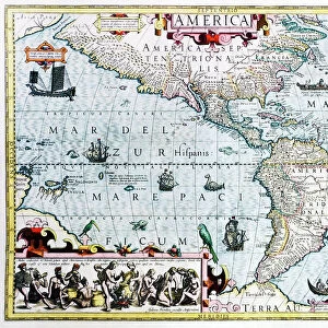
Geography map: representation of the south of the eastern coast of South America (Brazil and Argentina) from an Atlas made by the Italian cartographer Antonio Francesco Lucini (born in 1605), about 1661 Biblioteca Angelica, Rome
 from an Atlas made by the Italian cartographer Antonio Francesco Lucini (born in 1605), about 1661 Biblioteca Angelica, Rome")
![]()
Wall Art and Photo Gifts from Fine Art Finder
Geography map: representation of the south of the eastern coast of South America (Brazil and Argentina) from an Atlas made by the Italian cartographer Antonio Francesco Lucini (born in 1605), about 1661 Biblioteca Angelica, Rome
VEN5030453 Geography map: representation of the south of the eastern coast of South America (Brazil and Argentina) from an Atlas made by the Italian cartographer Antonio Francesco Lucini (born in 1605), about 1661 Biblioteca Angelica, Rome; (add.info.: Geography map: representation of the south of the eastern coast of South America (Brazil and Argentina) from an Atlas made by the Italian cartographer Antonio Francesco Lucini (born in 1605), about 1661 Biblioteca Angelica, Rome); © Marage Photos
Media ID 38426182
© © Marage Photos / Bridgeman Images
17eme Siecle Amerique Du Nord Amerique Du Sud Argentina Argentina Argentinean Argentine Argentine Argentin Argentins Argentines Argentinian Argentinians Brasil Brazil Brazil Brasilian Brazil Brazilian Brazilian Brazilians Bresil Bresilien Bresilienne Carte Geographique Etats Unis Geographie Latin America Stockravenna 17th Centuries Etats Unis Etats Unis Usa United States Geographical Map Latine America
FEATURES IN THESE COLLECTIONS
> Europe
> Italy
> Lazio
> Rome
> Fine Art Finder
> Artists
> Pasquier (workshop of) Grenier
> Maps and Charts
> Early Maps
> Maps and Charts
> Italy
> Maps and Charts
> Related Images
> North America
> United States of America
> Maps
> South America
> Argentina
> Maps
> South America
> Argentina
> Related Images
> South America
> Brazil
> Maps
EDITORS COMMENTS
This stunning print captures a detailed geography map of the south of the eastern coast of South America, specifically showcasing Brazil and Argentina. Created by the talented Italian cartographer Antonio Francesco Lucini around 1661, this piece is housed in the Biblioteca Angelica in Rome.
The intricate details on this map provide a glimpse into how these countries were represented in the 17th century. From the coastlines to the rivers and mountains, every feature is meticulously depicted with precision and accuracy.
As you study this map, you can't help but marvel at the craftsmanship and skill that went into creating such a masterpiece during a time when cartography was still evolving. The historical significance of this piece cannot be understated, as it offers valuable insights into how people viewed and understood geography centuries ago.
Whether you have a passion for history, geography, or art, this print is sure to captivate your imagination and transport you back in time to explore the lands of Brazil and Argentina through the eyes of Antonio Francesco Lucini. It serves as a reminder of our ever-changing world and how maps continue to shape our understanding of it.
MADE IN THE USA
Safe Shipping with 30 Day Money Back Guarantee
FREE PERSONALISATION*
We are proud to offer a range of customisation features including Personalised Captions, Color Filters and Picture Zoom Tools
SECURE PAYMENTS
We happily accept a wide range of payment options so you can pay for the things you need in the way that is most convenient for you
* Options may vary by product and licensing agreement. Zoomed Pictures can be adjusted in the Cart.