Home > Arts > Artists > H > Hubert Hubert
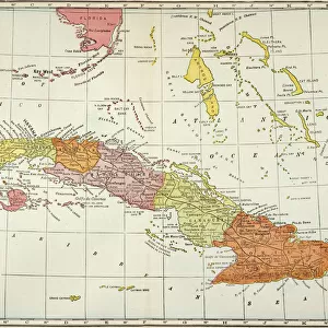
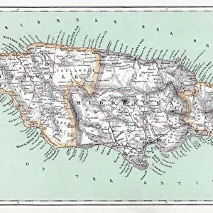
Geography Atlas: representation of North America and the Caribbean Sea region, Caribbean (Cuba, Jamaica, Hispaniola, Jamaica). Map from an Atlas by Adrien Hubert Brue (1786-1832), 1821. Biblioteca Jose Marti, Havana, Cuba
. Map from an Atlas by Adrien Hubert Brue (1786-1832), 1821. Biblioteca Jose Marti, Havana, Cuba")
![]()
Wall Art and Photo Gifts from Fine Art Finder
Geography Atlas: representation of North America and the Caribbean Sea region, Caribbean (Cuba, Jamaica, Hispaniola, Jamaica). Map from an Atlas by Adrien Hubert Brue (1786-1832), 1821. Biblioteca Jose Marti, Havana, Cuba
VEN5030064 Geography Atlas: representation of North America and the Caribbean Sea region, Caribbean (Cuba, Jamaica, Hispaniola, Jamaica). Map from an Atlas by Adrien Hubert Brue (1786-1832), 1821. Biblioteca Jose Marti, Havana, Cuba.; (add.info.: Geography Atlas: representation of North America and the Caribbean Sea region, Caribbean (Cuba, Jamaica, Hispaniola, Jamaica). Map from an Atlas by Adrien Hubert Brue (1786-1832), 1821. Biblioteca Jose Marti, Havana, Cuba.); © Marage Photos
Media ID 38425738
© © Marage Photos / Bridgeman Images
Amerique Centrale Amerique Du Nord Caraïbes Caribbean Caribbean Island Carte Geographique Central America Etats Unis Geographie Stockravenna Geographical Map
FEATURES IN THESE COLLECTIONS
> Arts
> Artists
> H
> Hubert Hubert
> Fine Art Finder
> Artists
> Pasquier (workshop of) Grenier
> Maps and Charts
> Early Maps
> Maps and Charts
> Related Images
> North America
> Cuba
> Cuba Heritage Sites
> Old Havana and its Fortification System
> North America
> Cuba
> Havana
> North America
> Cuba
> Maps
> North America
> Cuba
> Related Images
> North America
> Jamaica
> Maps
> North America
> Jamaica
> Related Images
EDITORS COMMENTS
This stunning print of a Geography Atlas from 1821 showcases the intricate representation of North America and the Caribbean Sea region, including countries such as Cuba, Jamaica, Hispaniola, and more. Created by Adrien Hubert Brue in the early 19th century, this map is a true work of art that captures the essence of these diverse lands.
Displayed at the Biblioteca Jose Marti in Havana, Cuba, this piece offers a glimpse into the geographical knowledge and cartographic skills of that time period. The detailed engravings on this map highlight not only the physical features of each country but also provide insight into their cultural significance.
As we study this map closely, we can appreciate the craftsmanship and attention to detail that went into its creation. From the western hemisphere to central America and beyond, every inch of this map tells a story about our world's past.
Whether you are a history buff or simply fascinated by geography, this print is sure to captivate your imagination. It serves as a reminder of how far we have come in understanding our planet's complexities while also honoring those who paved the way for modern cartography.
MADE IN THE USA
Safe Shipping with 30 Day Money Back Guarantee
FREE PERSONALISATION*
We are proud to offer a range of customisation features including Personalised Captions, Color Filters and Picture Zoom Tools
SECURE PAYMENTS
We happily accept a wide range of payment options so you can pay for the things you need in the way that is most convenient for you
* Options may vary by product and licensing agreement. Zoomed Pictures can be adjusted in the Cart.